
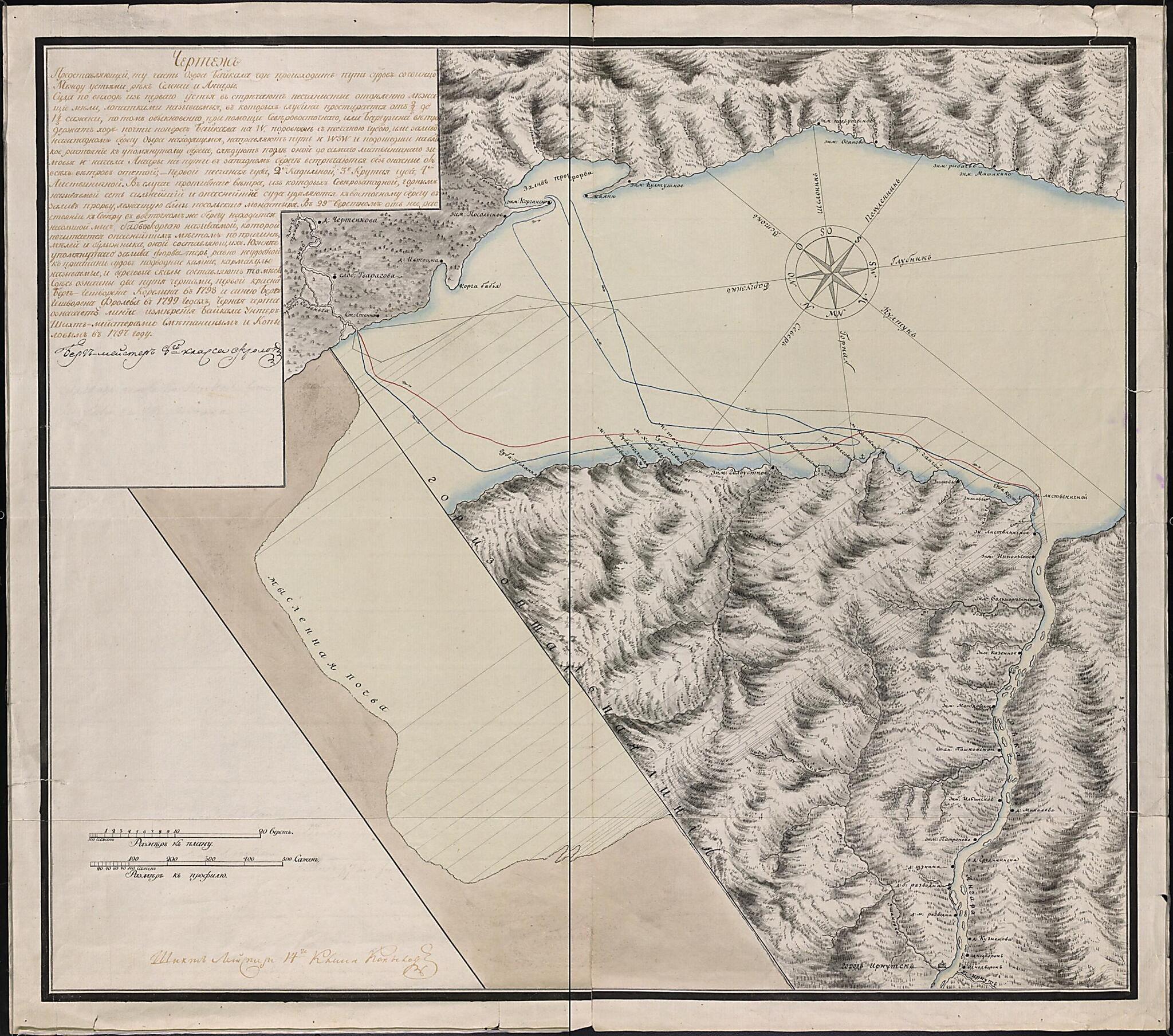
Chertëzh, Predstavli︠a︡i︠u︡shchiĭ Tu Chast' Ozera Baĭkal, Gde Prokhodi︠a︡tputi Sudov So Svint︠s︡ommezhdu Ust'i︠a︡mi Rek Selengi I Angary. (Чертёж, представляющий ту часть озера Байкал, гд�...
- Regular price
-
$62.95 - Regular price
-
$57.95 - Sale price
-
$62.95
Buy one map, get any other map in our collection for 50% OFF! Add to cart to see discount.
Couldn't load pickup availability
About This Map
Discover the timeless beauty of our fine art quality printed reproduction of this antique map. Perfect for history enthusiasts, collectors, and interior decorators.
Restored with meticulous attention to detail by our team with over a decade of experience, this stunning reproduction captures the intricate artistry and historical significance of the original map.
Whether you're a collector or seeking a unique decor piece, this archival-quality map reproduction is a timeless addition to any space. Order now to bring history to life!
Old map of Buryatia, Irkutsk Oblast, Republic of, Russian Federation.section toward the lower left of the map that correlates by line to the appropriate geographic location on the lake surface. A map legend indicates water depth in sazhens, a unit of measurement equal to 2.13 meters. Land relief is represented by hachures and shading, with vegetation and forests indicated by shading as well. The map legend indicates distance in versts, a tsarist-era unit of length equal to 1.07 kilometers. An explanatory text is provided in the upper-left corner that explains some regional geography and variations in shipping routes depending upon prevailing winds. World Digital Library.
Created by K. Frolov, Kopylov in 1799.
- Unikal'nai︠a︡ rukopisnai︠a︡ karta kont︠s︡a 18 stoletii︠a︡, vypolnennai︠a︡ geologom berg-masterom 8 klassa K. Frolovym i shikhmasterom 14 klassa Kopylovym, kotorye rabotali v Nerchinskoĭ ėkspedit︠s︡ii i chertili geograficheskie karty. Detal'no narisovano poberezh'e Baĭkala. Privedeny profili promerov glubin ozera. Karta orientirovana na I︠U︡g i i︠u︡go-vostok. Rel'ef izobrazhen shtrikhami i otmyvkoĭ, chto sozdaet kartinu ob"emnogo rel'efa.
- Original map at: Russian State Library
- Уникальная рукописная карта конца 18 столетия, выполненная геологом берг-мастером 8 класса К. Фроловым и шихмастером 14 класса Копыловым, которые работали в Нерчинской экспедиции и чертили географические карты. Детально нарисовано побережье Байкала. Приведены профили промеров глубин озера. Карта ориентирована на Юг и юго-восток. Рельеф изображен штрихами и отмывкой, что создает картину объемного рельефа.
Map Subjects
Baikal Lake (Russia)
Buryatia Republic Of
Irkutsk Oblast
Russian Federation
Siberia
Buryatia
Republic Of
K. Frolov
Kopylov
1799
- For the best legibility, order your map in the original size or larger. Most maps have intricate detail and small text that is best appreciated when the print size hasn't been reduced.
- Sizes labeled "Fits a Standard Frame" will drop right into any frame that you purchase in that size. The sizes that we offer are commonly available online and at most retail stores.
- Our standard sizes are recommendations based on the aspect ratio of the original map, but still may require some added "white space" in one dimension to fit.
- Non-standard sizes will require custom framing, and we suggest taking your print to the frame shop of your choice after you receive it for the best results.
- Custom sizes are available, simply contact us for a quote.
Below is an approximation of the scale of a few standard sizes, and how they might appear in your space.

