
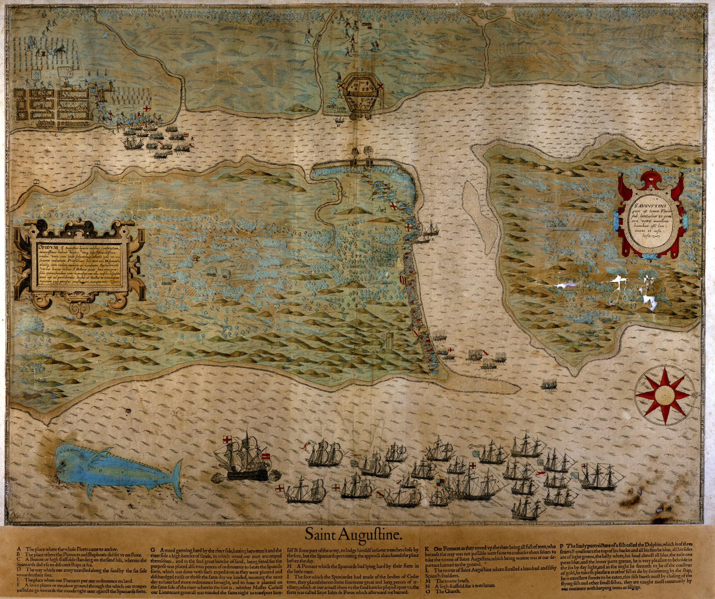
Saint Augustine Map, 1589
- Regular price
-
$49.95 - Regular price
-
$34.95 - Sale price
-
$49.95
Buy one map, get any other map in our collection for 50% OFF! Add to cart to see discount.
Couldn't load pickup availability
About This Map
Discover the timeless beauty of our fine art quality printed reproduction of this antique map. Perfect for history enthusiasts, collectors, and interior decorators.
Restored with meticulous attention to detail by our team with over a decade of experience, this stunning reproduction captures the intricate artistry and historical significance of the original map.
Whether you're a collector or seeking a unique decor piece, this archival-quality map reproduction is a timeless addition to any space. Order now to bring history to life!
Old map of Florida, Saint Augustine, United States of America.colored map or view-plan by Baptista Boazio depicts Sir Francis Drake's attack on Saint Augustine on May 28-29, 1586. Boazio, an Italian who worked in London from about 1585 to 1603, made maps to illustrate accounts of English expeditions and campaigns. He prepared a series of maps marking Drake's route for Walter Bigges' work on Drake's expedition to the West Indies, first published in 1588 and followed by later editions. This map highlights an episode from Drake's Caribbean expedition, pictorially portraying how the English corsair (privateer) captured and burned the fort and city of Saint Augustine. The plan includes an illustration of a mahi-mahi, also known as a dolphinfish, which Boazio most likely copied from drawings by John White, governor of the Raleigh settlement in what was then Virginia (present-day North Carolina). Boazio's map is the earliest engraving of any city or territory now part of the United States. Another version of the map survives in the collections of the Library of Congress. The two maps differ in their coloring, but are otherwise identical.
Created by Baptista Boazio, John White in 1589.
- Title devised, in English, by Library staff.
- Original resource at: State Library and Archives of Florida.
- Content in English and Latin.
- Description based on data extracted from World Digital Library, which may be extracted from partner institutions.
- For the best legibility, order your map in the original size or larger. Most maps have intricate detail and small text that is best appreciated when the print size hasn't been reduced.
- Sizes labeled "Fits a Standard Frame" will drop right into any frame that you purchase in that size. The sizes that we offer are commonly available online and at most retail stores.
- Our standard sizes are recommendations based on the aspect ratio of the original map, but still may require some added "white space" in one dimension to fit.
- Non-standard sizes will require custom framing, and we suggest taking your print to the frame shop of your choice after you receive it for the best results.
- Custom sizes are available, simply contact us for a quote.
Below is an approximation of the scale of a few standard sizes, and how they might appear in your space.

