
Scaled Coastal Map of Japan, Eastern Provinces (Ino Maps) 1804
- Regular price
-
$130.95 - Regular price
-
$125.95 - Sale price
-
$130.95
Buy one map, get any other map in our collection for 50% OFF! Add to cart to see discount.
Couldn't load pickup availability
About This Map
Discover the timeless beauty of our fine art quality printed reproduction of this antique map. Perfect for history enthusiasts, collectors, and interior decorators.
Restored with meticulous attention to detail by our team with over a decade of experience, this stunning reproduction captures the intricate artistry and historical significance of the original map.
Whether you're a collector or seeking a unique decor piece, this archival-quality map reproduction is a timeless addition to any space. Order now to bring history to life!
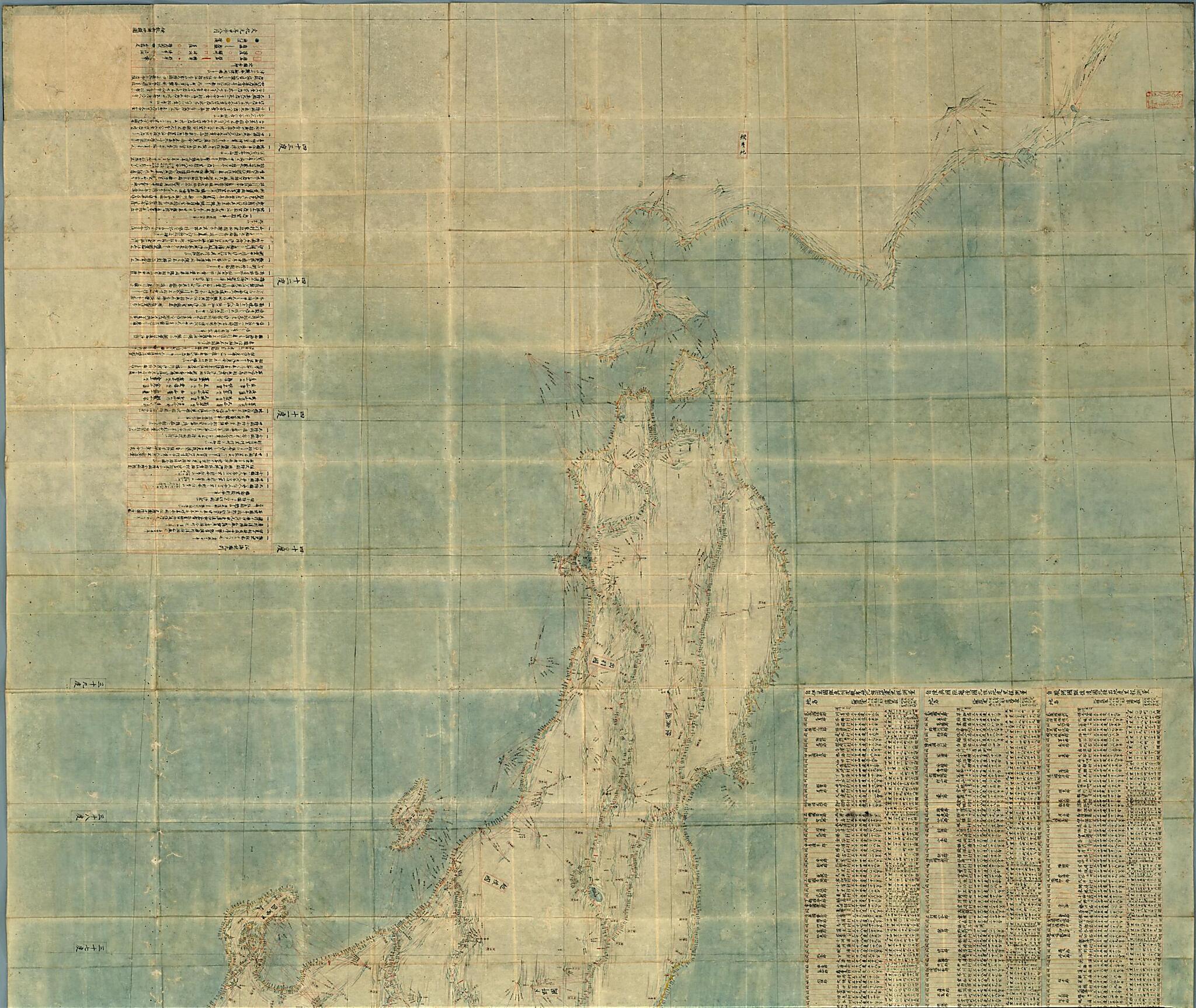
Old map of Japan.1818) was a famous surveyor and cartographer of the Edo period in Japan. He is known for completing the first map of Japan based on actual measurements, which he himself made by traveling throughout the country. In 1800 Inō surveyed the area from Edo (present-day Tokyo) to Nemuro (in present-day Hokkaidō) on the Ōshū Highway. He continued measuring other parts of eastern Japan until 1803. He compiled the results of his surveys into three sets of maps of different scales, which he presented to the shogunate in 1804. Shown here is the smallest-scale version (1:432,000). The lines radiating from the summits of mountains and from islands were used to measure the azimuth from certain fixed points; they indicate that Tadataka adopted junbō or kōkaihō, the old East Asian intersection method to determine the location of distant points by flat surveying. The two vermillion imprints of seals on the title piece and on the sheet of the map itself indicate that the work was once owned by Nakagawa Tadahide, a kanjō-bugyō (official of the Tokugawa shogunate with responsibility for finance) from 1797 to 1806.
Created by Tadataka Inō in 1804.
- Title devised, in English, by Library staff.
- Original resource extent: 1 sheet ; 223 x 258 centimeters.
- Original resource at: National Diet Library.
- Content in Japanese.
- Description based on data extracted from World Digital Library, which may be extracted from partner institutions.
Map Subjects
Japan
Manuscript Maps
Tadataka Inō
1804
- For the best legibility, order your map in the original size or larger. Most maps have intricate detail and small text that is best appreciated when the print size hasn't been reduced.
- Sizes labeled "Fits a Standard Frame" will drop right into any frame that you purchase in that size. The sizes that we offer are commonly available online and at most retail stores.
- Our standard sizes are recommendations based on the aspect ratio of the original map, but still may require some added "white space" in one dimension to fit.
- Non-standard sizes will require custom framing, and we suggest taking your print to the frame shop of your choice after you receive it for the best results.
- Custom sizes are available, simply contact us for a quote.
Below is an approximation of the scale of a few standard sizes, and how they might appear in your space.

