
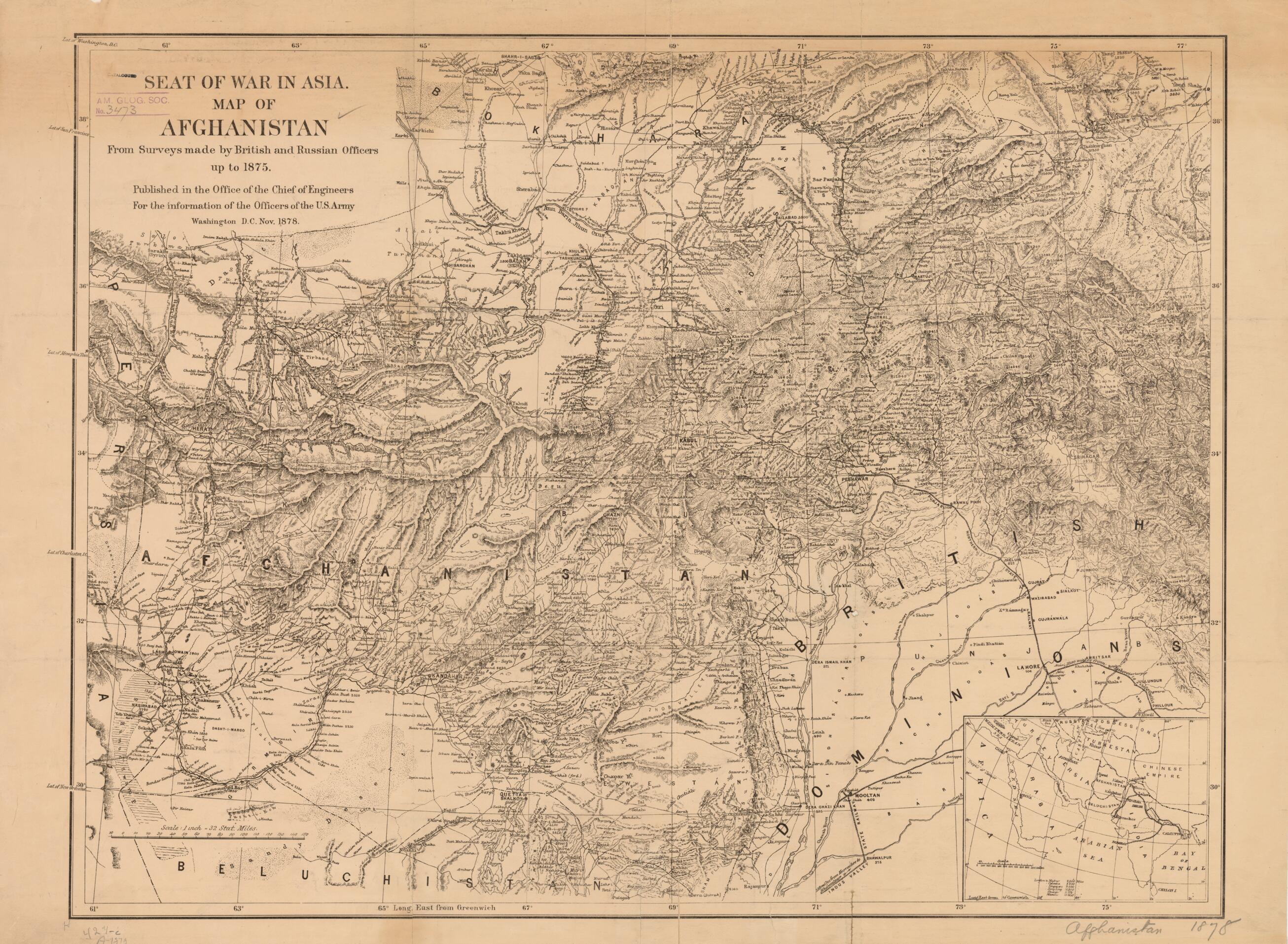
Seat of War In Asia. Map of Afghanistan from Surveys Made by British and Russian Officers Up to 1875 1878
- Regular price
-
$84.95 - Regular price
-
$79.95 - Sale price
-
$84.95
Buy one map, get any other map in our collection for 50% OFF! Add to cart to see discount.
Couldn't load pickup availability
About This Map
Discover the timeless beauty of our fine art quality printed reproduction of this antique map. Perfect for history enthusiasts, collectors, and interior decorators.
Restored with meticulous attention to detail by our team with over a decade of experience, this stunning reproduction captures the intricate artistry and historical significance of the original map.
Whether you're a collector or seeking a unique decor piece, this archival-quality map reproduction is a timeless addition to any space. Order now to bring history to life!
Old map of Afghanistan.Afghan War, launched by a British invasion on November 21, 1878. The pretext for military action was the refusal of the Afghan government to admit the British envoy, Sir Neville Chamberlain, who had been dispatched to Kabul by the orders of Lord Lytton, the governor-general of India. The Afghan ruler Sher Ali Khan (reigned 1863-66 and 1868-79) had already and with some reluctance admitted into Kabul a Russian delegation led by General Nikolai Grigorevich Stoletov. In the context of the political rivalry that existed between Russia and Great Britain over the control of Central Asia, this preference toward Russia was a slight which, from the British perspective, could not be allowed to stand unchallenged. Major fighting in the Second Anglo-Afghan War did not cease until the Battle of Kandahar in September 1880, after which Afghanistan ceded control of its foreign affairs to the British government. Compiled and printed by the Office of the Chief of Engineers of the United States Army "for the information of the officers of the U.S. Army," the map includes along its western edge markings indicating the latitude of a number of cities in the United States to be used as reference for its North American readers.
Created by Great Britain, Russia, United States. Army. Office of the Chief of Engineers in 1878.
- Title devised, in English, by Library staff.
- "Scale 1:2,027,520"--Note extracted from World Digital Library.
- Original resource extent: 1 map ; 56 x 74 centimeters.
- Original resource at: University of Wisconsin-Milwaukee Libraries.
- Content in English.
- Description based on data extracted from World Digital Library, which may be extracted from partner institutions.
- For the best legibility, order your map in the original size or larger. Most maps have intricate detail and small text that is best appreciated when the print size hasn't been reduced.
- Sizes labeled "Fits a Standard Frame" will drop right into any frame that you purchase in that size. The sizes that we offer are commonly available online and at most retail stores.
- Our standard sizes are recommendations based on the aspect ratio of the original map, but still may require some added "white space" in one dimension to fit.
- Non-standard sizes will require custom framing, and we suggest taking your print to the frame shop of your choice after you receive it for the best results.
- Custom sizes are available, simply contact us for a quote.
Below is an approximation of the scale of a few standard sizes, and how they might appear in your space.

