
Sept. 1776)
- Regular price
-
$249.95 - Regular price
-
$244.95 - Sale price
-
$249.95
Buy one map, get any other map in our collection for 50% OFF! Add to cart to see discount.
Couldn't load pickup availability
About This Map
Discover the timeless beauty of our fine art quality printed reproduction of this antique map. Perfect for history enthusiasts, collectors, and interior decorators.
Restored with meticulous attention to detail by our team with over a decade of experience, this stunning reproduction captures the intricate artistry and historical significance of the original map.
Whether you're a collector or seeking a unique decor piece, this archival-quality map reproduction is a timeless addition to any space. Order now to bring history to life!
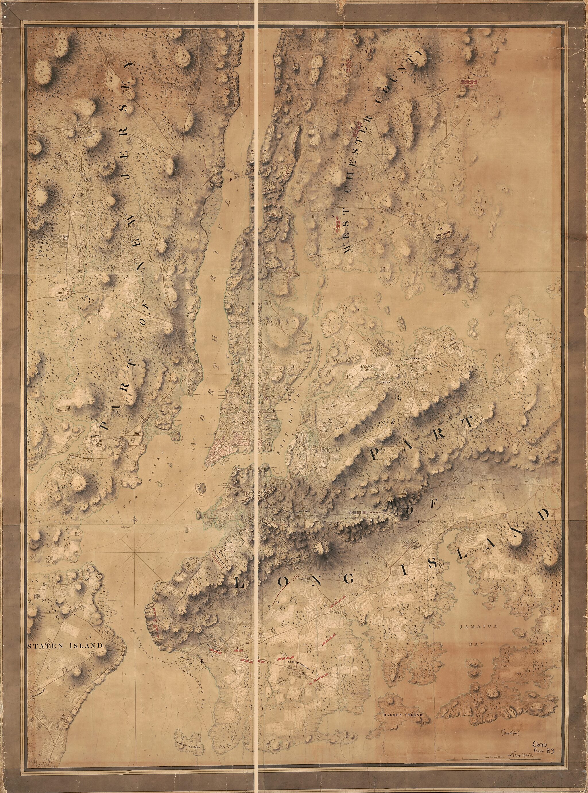
Old map of Long Island, New York, New York (State), New York City, United States.- Covers present-day New York City vicinity including Staten Island, Palisades area (N.J.), New Rochelle (N.Y.), and Jamaica Bay.
- Shows troop positions, fortifications, ship anchorage areas, roads, built-up areas, villages, and agricultural field areas.
- Relief shown by shading, hachures, and landform drawings. Depths shown by contours and soundings.
- Title devised by cataloger.
- Map appears to be a composite copied from the DesBarres sheets of the Atlantic Neptune.
- Map originally in the British archives at Cricklewood (near London), where a twin copy was retained.
- Pen-and-ink and watercolors.
- This map has some imperfections: cracked from rolling, torn at top, has metal grommets at upper left corner of margin. We'll do our best to restore the image before printing.
- Originally drawn on 10 sheets.
- In later hand (ink) at lower right: (Two copies) L690, Press 83, New York.
- Handwritten and rubber-stamped on verso on cloth backing: L690 (2) Press 83.
- Accompanied by 2 textual description signs from former exhibitions of the map: Battle of New York, August-September 1776. [1] sheet : paperboard ; 29 x 25 cm. -- Battle of New York. [1] sheet : paperboard ; 28 x 42 cm.
- Transfer; National Ocean Service, NOAA 2000.
Map Subjects
Early Works To 1800
Fortification
Harlem Heights Battle Of N.Y.
History
Long Island
Long Island Battle Of New York N.Y.
Manhattan
Maps Manuscript
Morningside Heights
New York
New York (N.Y.)
New York (State)
Revolution
United States
New York City
1776
- For the best legibility, order your map in the original size or larger. Most maps have intricate detail and small text that is best appreciated when the print size hasn't been reduced.
- Sizes labeled "Fits a Standard Frame" will drop right into any frame that you purchase in that size. The sizes that we offer are commonly available online and at most retail stores.
- Our standard sizes are recommendations based on the aspect ratio of the original map, but still may require some added "white space" in one dimension to fit.
- Non-standard sizes will require custom framing, and we suggest taking your print to the frame shop of your choice after you receive it for the best results.
- Custom sizes are available, simply contact us for a quote.
Below is an approximation of the scale of a few standard sizes, and how they might appear in your space.

