
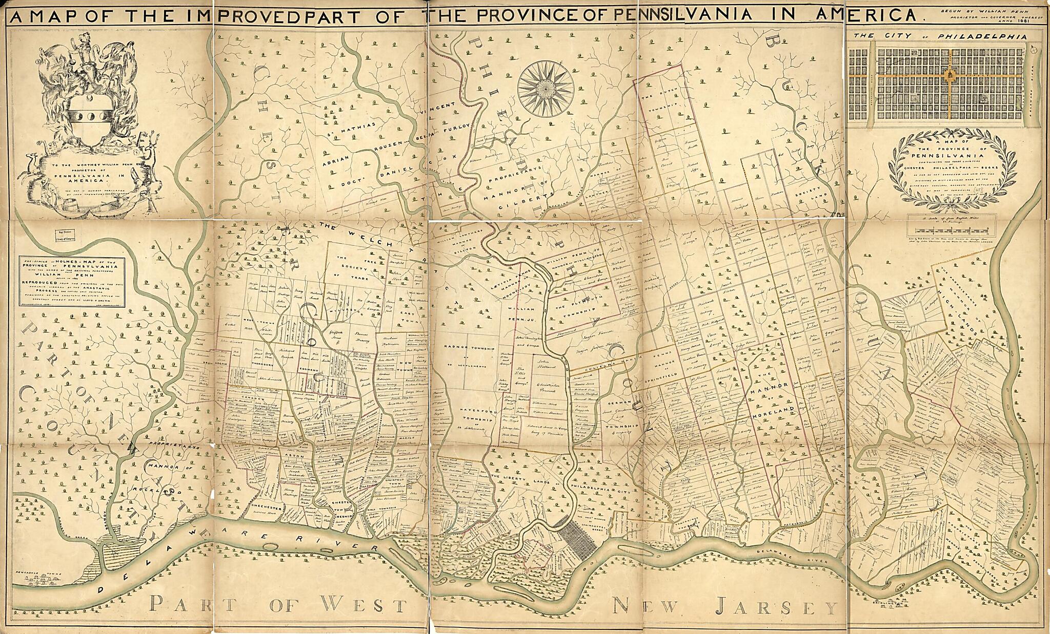
Simile of Holmes-map of the Province of Pennsylvania : With the Names of the Original Purchasers From William Penn, Begun In 1681 in 1687
- Regular price
-
$172.95 - Regular price
-
$167.95 - Sale price
-
$172.95
Buy one map, get any other map in our collection for 50% OFF! Add to cart to see discount.
Couldn't load pickup availability
About This Map
Discover the timeless beauty of our fine art quality printed reproduction of this antique map. Perfect for history enthusiasts, collectors, and interior decorators.
Restored with meticulous attention to detail by our team with over a decade of experience, this stunning reproduction captures the intricate artistry and historical significance of the original map.
Whether you're a collector or seeking a unique decor piece, this archival-quality map reproduction is a timeless addition to any space. Order now to bring history to life!
Old map of Pennsylvania, Philadelphia, Philadelphia Region, United States.Created by Robert Greene, Thomas Holme, Lloyd P. (Lloyd Pearsall) Smith, John Thornton in 1687.
- Shows rural landholders' names and lots in the Philadelphia region.
- Alternate title at top: A map of the improved part of the province of Pennsylvania in America : begun by William Penn, proprietor and governor thereof, anno 1681.
- Facsim. "Reproduced from the original in the Philadelphia Library by the anastatic process."
- Original version: A map of the province of Pennsilvania : containing the three countyes of Chester, Philadelphia, and Bucks as far as yet surveyed ... by way of townships / by Tho. Holme, survey'r gen'l. London : Sold by Rob. Greene ... and by John Thornton, [1687?].
- Includes inset of "The city of Philadelphia," statement of dedication "By John Thornton & Robert Greene," and coat-of-arms.
- Ristow. American maps and mapmakers
Map Subjects
Administrative And Political Divisions
Early Works To 1800
Facsimiles
Pennsylvania
Philadelphia
Philadelphia (Pa.)
Philadelphia Region
Philadelphia Region (Pa.)
Real Property
United States
Robert Greene
Thomas Holme
Lloyd P. (Lloyd Pearsall) Smith
John Thornton
1687
- For the best legibility, order your map in the original size or larger. Most maps have intricate detail and small text that is best appreciated when the print size hasn't been reduced.
- Sizes labeled "Fits a Standard Frame" will drop right into any frame that you purchase in that size. The sizes that we offer are commonly available online and at most retail stores.
- Our standard sizes are recommendations based on the aspect ratio of the original map, but still may require some added "white space" in one dimension to fit.
- Non-standard sizes will require custom framing, and we suggest taking your print to the frame shop of your choice after you receive it for the best results.
- Custom sizes are available, simply contact us for a quote.
Below is an approximation of the scale of a few standard sizes, and how they might appear in your space.
