
Sixth Map of Asia. (Tabula VI Asiae) 1525
- Regular price
-
$50.95 - Regular price
-
$45.95 - Sale price
-
$50.95
Buy one map, get any other map in our collection for 50% OFF! Add to cart to see discount.
Couldn't load pickup availability
About This Map
Discover the timeless beauty of our fine art quality printed reproduction of this antique map. Perfect for history enthusiasts, collectors, and interior decorators.
Restored with meticulous attention to detail by our team with over a decade of experience, this stunning reproduction captures the intricate artistry and historical significance of the original map.
Whether you're a collector or seeking a unique decor piece, this archival-quality map reproduction is a timeless addition to any space. Order now to bring history to life!
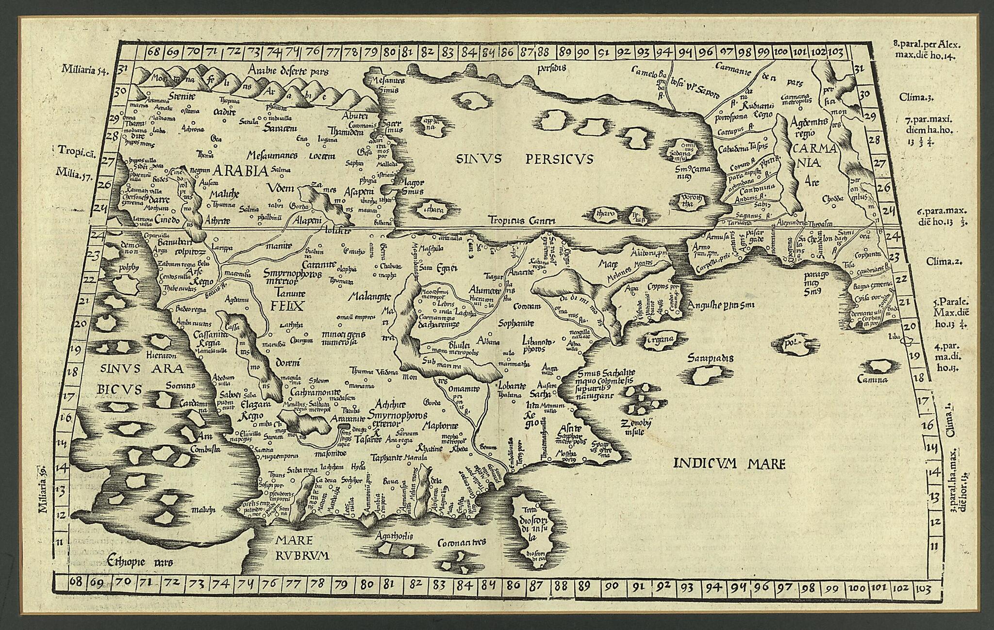
Old map of Bahrain, Iraq, Kuwait, Oman, Qatar, Saudi Arabia, United Arab Emirates, Yemen.-circa 170), known as Ptolemy, was an astronomer, mathematician, and geographer of Greek descent who lived and worked in the Egyptian city of Alexandria. In his Geography, Ptolemy gathered all the geographic knowledge possessed by the Greco-Roman world. He invented the geographic coordinate system and devised a method of using a grid or graticule made up of lines of latitude and longitude to plot the locations of some 8,000 places on the map that encompassed the known world at the height of the Roman Empire. Ptolemy's work was lost to Europe in the Middle Ages, but at the beginning of the 14th century Byzantine scholars began introducing versions of it into Italy. Johann Grüninger printed an edition of Ptolemy's Geography in Strasbourg in 1522. He later reused the blocks for an enlarged edition that appeared in 1525. Shown here is his April 1525 print of Ptolemy's Tabula VI Asiae (Sixth map of Asia), published by Johann Koberger (circa 1454-1543) in Argentorati (i.e., Strasbourg). The text was translated into Latin by Willibald Pirckheimer (1470-1530), a scholar from Nuremberg. The map is dominated by the Arabian Peninsula. The area shown stretches from part of Ethiopia in the southwest to the Indian Ocean in the southeast, and from the Arabian Desert in the northwest to Carmania (present-day Kerman Province, Iran) in the northeast. The shape of the Arabian Gulf is very loosely defined. The Tropic of Cancer is shown.
Created by Willibald Pirckheimer, 2nd Century Ptolemy, Joannes Regiomontanus in 1525.
- Title devised, in English, by Library staff.
- "Scale approximately 1:9,000,000"--Note extracted from World Digital Library.
- Original resource extent: 1 map ; 26 x 42 centimeters.
- Original resource at: Qatar National Library.
- Content in Latin.
- Description based on data extracted from World Digital Library, which may be extracted from partner institutions.
Map Subjects
100 To 170
Arabian Gulf
Arabian Peninsula
Bahrain
Geography Ancient
Iraq
Kuwait
Oman
Persian Gulf
Qatar
Red Sea
Saudi Arabia
United Arab Emirates
Yemen
Willibald Pirckheimer
2nd Century Ptolemy
Joannes Regiomontanus
1525
- For the best legibility, order your map in the original size or larger. Most maps have intricate detail and small text that is best appreciated when the print size hasn't been reduced.
- Sizes labeled "Fits a Standard Frame" will drop right into any frame that you purchase in that size. The sizes that we offer are commonly available online and at most retail stores.
- Our standard sizes are recommendations based on the aspect ratio of the original map, but still may require some added "white space" in one dimension to fit.
- Non-standard sizes will require custom framing, and we suggest taking your print to the frame shop of your choice after you receive it for the best results.
- Custom sizes are available, simply contact us for a quote.
Below is an approximation of the scale of a few standard sizes, and how they might appear in your space.
