
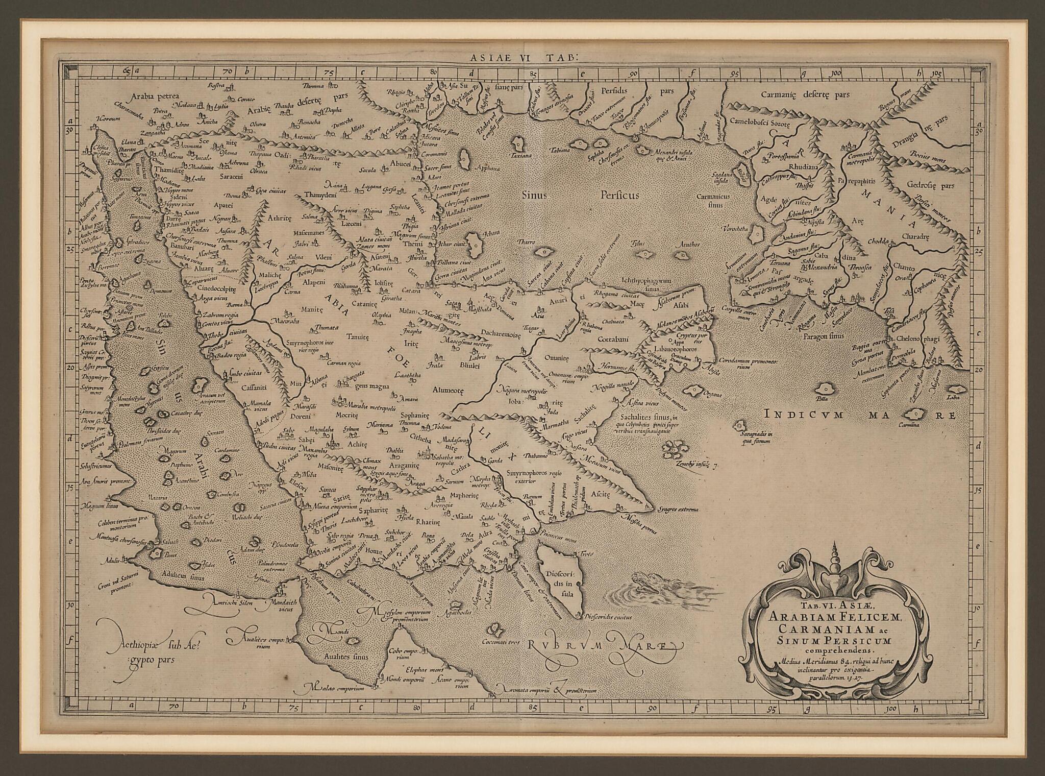
Sixth Map of Asia, Including Arabia Felix, Carmania, and the Arabian Gulf. (Tab. VI : Asiæ, Arabiam Felicem, Carmaniam Ac Sinum Persicum) 1578
- Regular price
-
$67.95 - Regular price
-
$62.95 - Sale price
-
$67.95
Buy one map, get any other map in our collection for 50% OFF! Add to cart to see discount.
Couldn't load pickup availability
About This Map
Discover the timeless beauty of our fine art quality printed reproduction of this antique map. Perfect for history enthusiasts, collectors, and interior decorators.
Restored with meticulous attention to detail by our team with over a decade of experience, this stunning reproduction captures the intricate artistry and historical significance of the original map.
Whether you're a collector or seeking a unique decor piece, this archival-quality map reproduction is a timeless addition to any space. Order now to bring history to life!
Old map of Bahrain, Iraq, Kuwait, Oman, Qatar, Saudi Arabia, United Arab Emirates, Yemen.-circa 170), known as Ptolemy, was an astronomer, mathematician, and geographer of Greek descent who lived and worked in the Egyptian city of Alexandria. In his Geography, Ptolemy gathered all the geographic knowledge possessed by the Greco-Roman world. He invented the geographic coordinate system and devised a method of using a grid or graticule made up of lines of latitude and longitude to plot the locations of some 8,000 places on the map that encompassed the known world at the height of the Roman Empire. Ptolemy's work was lost to Europe in the Middle Ages, but at the beginning of the 14th century Byzantine scholars began introducing versions of it into Italy. Gerard Mercator (1512--94) was born in Rupelmonde in Flanders (Belgium). He studied philosophy and theology at the University of Leuven, and developed an interest in astronomy and mathematics. He produced his first map, of Palestine, in 1537. He went on to create numerous maps and globes in the course of his long career and is best known for his invention of the Mercator map projection, a revolutionary advance in the science of cartography and one which became the standard for navigation at sea using charts based on this map projection. In 1578 Mercator conceived a plan to publish a great atlas of the world containing up to 100 maps. His interpretations of Ptolemy's texts are amongst the most faithful made up to his day. The map presented here, a copperplate engraving, shows the entirety of the Arabian Peninsula and parts of Africa and Persia. Details of the topography of the interior are almost completely fanciful, although some of the place-names have more than historical interest. Qatar is called Catara. One of the peninsulas shown on the map north of the location labeled Catara is named "Chersonesi Extrema," meaning "the end point of the peninsula." Modern scholarship has identified it as present-day Ra's Rakan in Qatar. Ichtyophagorium Sinus is the gulf inhabited by the people identified in ancient histories as the "Fish Eaters."
Created by Gerhard Mercator, 2nd Century Ptolemy in 1578.
- Title devised, in English, by Library staff.
- "Scale approximately 1:9,150,000"--Note extracted from World Digital Library.
- Original resource extent: 1 map ; 46 x 31 centimeters.
- Original resource at: Qatar National Library.
- Content in Latin.
- Description based on data extracted from World Digital Library, which may be extracted from partner institutions.
Map Subjects
100 To 170
Arabian Gulf
Arabian Peninsula
Bahrain
Geography Ancient
Iraq
Kuwait
Oman
Persian Gulf
Qatar
Red Sea
Saudi Arabia
United Arab Emirates
Yemen
Gerhard Mercator
2nd Century Ptolemy
1578
- For the best legibility, order your map in the original size or larger. Most maps have intricate detail and small text that is best appreciated when the print size hasn't been reduced.
- Sizes labeled "Fits a Standard Frame" will drop right into any frame that you purchase in that size. The sizes that we offer are commonly available online and at most retail stores.
- Our standard sizes are recommendations based on the aspect ratio of the original map, but still may require some added "white space" in one dimension to fit.
- Non-standard sizes will require custom framing, and we suggest taking your print to the frame shop of your choice after you receive it for the best results.
- Custom sizes are available, simply contact us for a quote.
Below is an approximation of the scale of a few standard sizes, and how they might appear in your space.

