
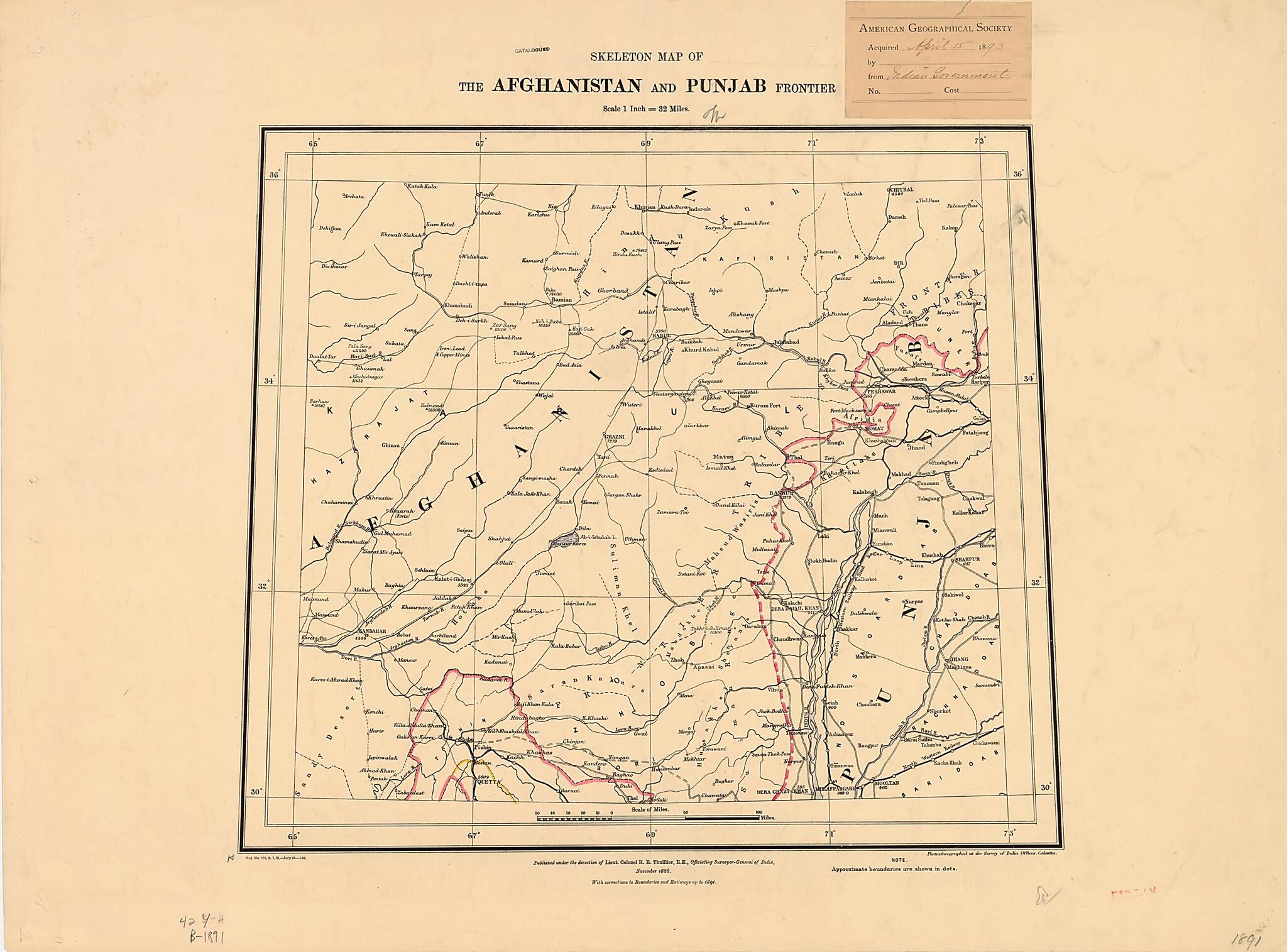
Skeleton Map of the Afghanistan and Punjab Frontier 1891
- Regular price
-
$63.95 - Regular price
-
$58.95 - Sale price
-
$63.95
Buy one map, get any other map in our collection for 50% OFF! Add to cart to see discount.
Couldn't load pickup availability
About This Map
Discover the timeless beauty of our fine art quality printed reproduction of this antique map. Perfect for history enthusiasts, collectors, and interior decorators.
Restored with meticulous attention to detail by our team with over a decade of experience, this stunning reproduction captures the intricate artistry and historical significance of the original map.
Whether you're a collector or seeking a unique decor piece, this archival-quality map reproduction is a timeless addition to any space. Order now to bring history to life!
Old map of Afghanistan, Balochistan, Pakistan.day Pakistan (then part of British India). It is dated July 1891, although it is a reissue of an earlier map of November 1886, with updated information on political boundaries and railways. The border between Afghanistan and Baluchistan was to be redrawn in 1893, just two years after the publication of this map, by the establishment of the Durand Line. An arbitrary political demarcation, the Durand Line cut through the boundaries of the various tribal entities residing in a region recognized for the fierce independence of its inhabitants. The area remains a source of political volatility today. The map was published during the directorship of the Survey of India of Colonel Sir Henry Ravenshaw Thuillier (1838--1922). Sir Henry was educated at the Addiscombe Military Seminary (also known as the East India Company Military Seminary), and led the Survey of India from 1886 to his retirement in 1895. Sir Henry's father, Sir Henry Edward Landor Thuillier, also led the Survey of India, in 1861-78. The map was reproduced by photozincography, a process of photolithography using a zinc plate. The scale is one inch to 32 miles (2.54 centimeters to 51.49 kilometers).
Created by Survey of India, H. R. (Henry Ravenshaw) Thuillier in 1891.
- Title devised, in English, by Library staff.
- "Scale 1:2,000,000"--Note extracted from World Digital Library.
- Original resource extent: 1 map : color ; 51 x 69 centimeters.
- Original resource at: University of Wisconsin-Milwaukee Libraries.
- Content in English.
- Description based on data extracted from World Digital Library, which may be extracted from partner institutions.
Map Subjects
1886 To 1891
Afghanistan
Balochistan
Expeditions And Surveys
Library Of Congress Afghanistan Project
Pakistan
Survey Of India
Survey Of India
H. R. (Henry Ravenshaw) Thuillier
1891
- For the best legibility, order your map in the original size or larger. Most maps have intricate detail and small text that is best appreciated when the print size hasn't been reduced.
- Sizes labeled "Fits a Standard Frame" will drop right into any frame that you purchase in that size. The sizes that we offer are commonly available online and at most retail stores.
- Our standard sizes are recommendations based on the aspect ratio of the original map, but still may require some added "white space" in one dimension to fit.
- Non-standard sizes will require custom framing, and we suggest taking your print to the frame shop of your choice after you receive it for the best results.
- Custom sizes are available, simply contact us for a quote.
Below is an approximation of the scale of a few standard sizes, and how they might appear in your space.

