
Sketch Map of British Guiana 1840
- Regular price
-
$62.95 - Regular price
-
$44.95 - Sale price
-
$62.95
Buy one map, get any other map in our collection for 50% OFF! Add to cart to see discount.
Couldn't load pickup availability
About This Map
Discover the timeless beauty of our fine art quality printed reproduction of this antique map. Perfect for history enthusiasts, collectors, and interior decorators.
Restored with meticulous attention to detail by our team with over a decade of experience, this stunning reproduction captures the intricate artistry and historical significance of the original map.
Whether you're a collector or seeking a unique decor piece, this archival-quality map reproduction is a timeless addition to any space. Order now to bring history to life!
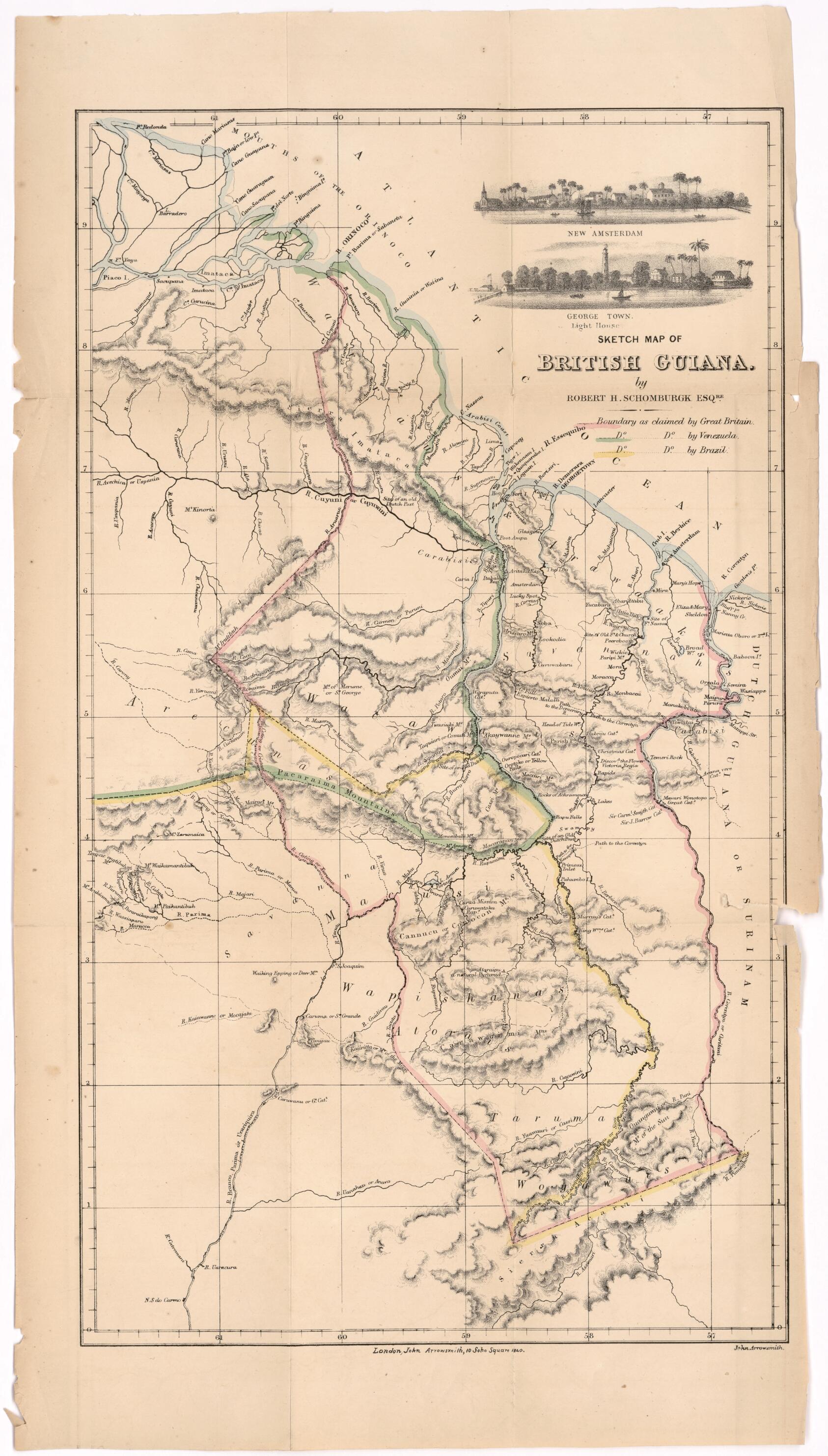
Old map of Guyana.-65) was a British naturalist and surveyor known for his pioneering surveys of British Guiana (present-day Guyana). Born and educated in Germany, he traveled to the West Indies in 1830 where he completed a survey of one of the Virgin Islands that was published in the Journal of the Royal Geographical Society. In 1835--39, under the direction of the Royal Geographical Society, he explored the Essequibo and Berbice Rivers in northern South America and completed a survey of British Guiana. Upon returning to Europe, he convinced the British government of the need to demarcate the boundaries of British Guiana. In April 1840, he was appointed commissioner for surveying and marking out the boundaries, which he completed in 1841--43. His proposals, known as the "Schomburgk line," figured prominently in the disputes of the late-19th century between Great Britain and Brazil and Venezuela over the borders of British Guiana. This "sketch map" by Schomburgk, published in London in 1840, shows the competing claims of Britain, Brazil, and Venezuela. At the top of the map are sketches of the port and lighthouse of Georgetown, Guyana and of New Amsterdam, Guyana (capital of the former Dutch colony of Berbice, which passed to British control in 1815).
Created by Robert H. (Robert Hermann) Schomburgk in 1840.
- Title devised, in English, by Library staff.
- Original resource extent: 1 map : color ; 28 x 50 centimeters.
- Reference extracted from World Digital Library: G. C. Boase, "Schomburgk, Sir Robert Hermann (1804--1865),"Oxford Dictionary of National Biography (Oxford: Oxford University Press, 2004).
- Original resource at: Columbus Memorial Library, Organization of American States.
- Content in English.
- Description based on data extracted from World Digital Library, which may be extracted from partner institutions.
- For the best legibility, order your map in the original size or larger. Most maps have intricate detail and small text that is best appreciated when the print size hasn't been reduced.
- Sizes labeled "Fits a Standard Frame" will drop right into any frame that you purchase in that size. The sizes that we offer are commonly available online and at most retail stores.
- Our standard sizes are recommendations based on the aspect ratio of the original map, but still may require some added "white space" in one dimension to fit.
- Non-standard sizes will require custom framing, and we suggest taking your print to the frame shop of your choice after you receive it for the best results.
- Custom sizes are available, simply contact us for a quote.
Below is an approximation of the scale of a few standard sizes, and how they might appear in your space.

