
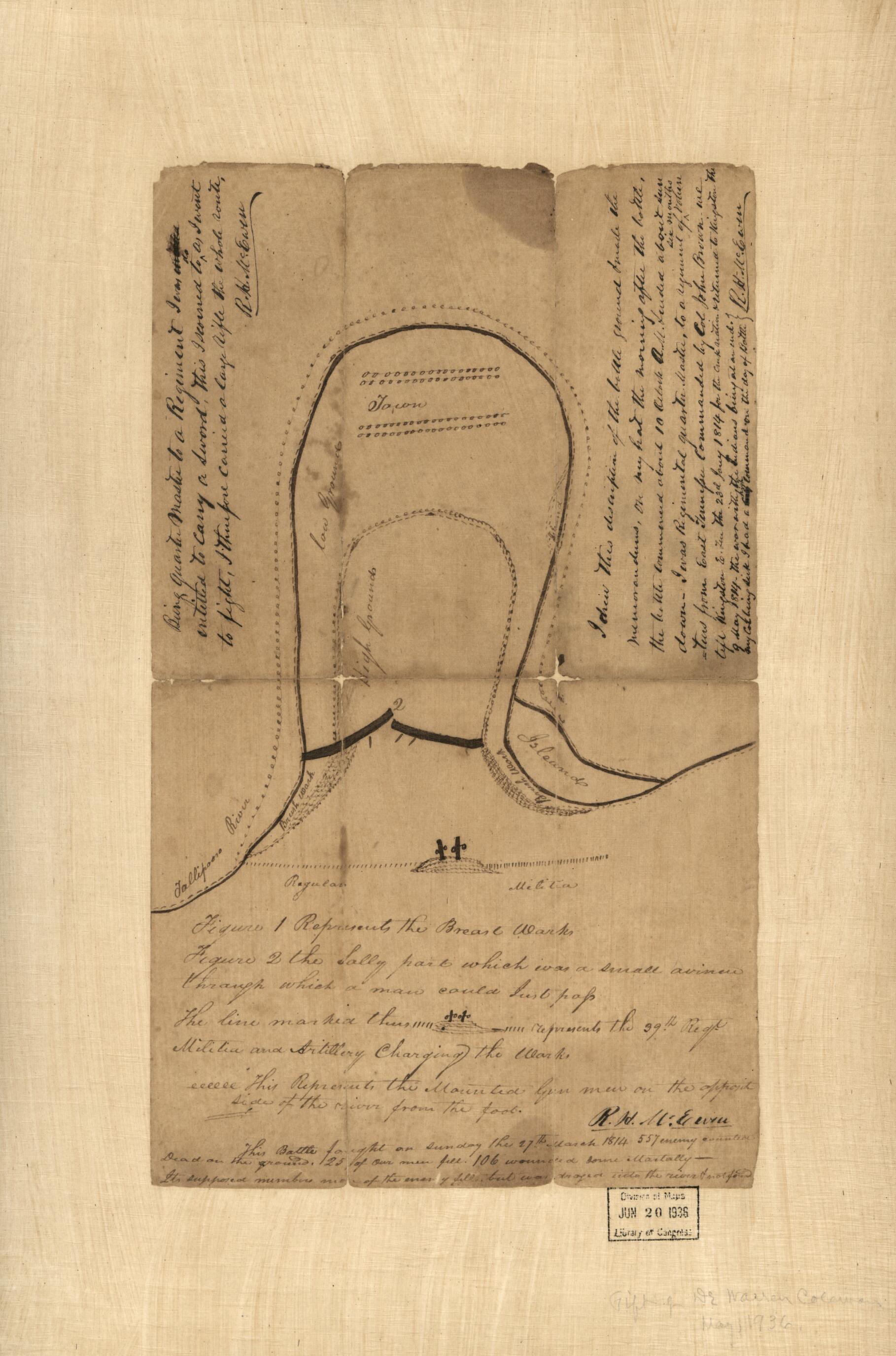
Sketch Map of the Battle of Horseshoe Bend of Tallapoosa River, 27th March 1814
- Regular price
-
$49.95 - Regular price
-
$34.95 - Sale price
-
$49.95
Buy one map, get any other map in our collection for 50% OFF! Add to cart to see discount.
Couldn't load pickup availability
About This Map
Discover the timeless beauty of our fine art quality printed reproduction of this antique map. Perfect for history enthusiasts, collectors, and interior decorators.
Restored with meticulous attention to detail by our team with over a decade of experience, this stunning reproduction captures the intricate artistry and historical significance of the original map.
Whether you're a collector or seeking a unique decor piece, this archival-quality map reproduction is a timeless addition to any space. Order now to bring history to life!
Old manuscript map of Alabama, Horseshoe Bend, United States.Created by R. H. (Robert Houston) McEwen in 1814.
- Shows fortifications and troop positions.
- Pen-and-ink. Mounted on cloth.
- Title provided by cataloger.
- "I drew this description of the battle ground & made the memorandums on my hat the morning after the battle, the battle commenced about 10 o'clock A.M. & ended about sundown. I was regimental quarter master, to a regiment of six months volunteers from East Tennessee commanded by Col. John Brown. We left Kinston, E. Ten. the 23rd Jany 1814 for the Creek nation & returned to Kingston the 9 May 1814, the war with the Indians being at an end. My Col. being sick I had a high command on the day of battle [signed] R.H. McEwen."
- Accompanied by presentation letter signed by Warren Coleman. [1] page ; 29 cm.
- Gift ; Warren Coleman ; May 26th, 1937.
- For the best legibility, order your map in the original size or larger. Most maps have intricate detail and small text that is best appreciated when the print size hasn't been reduced.
- Sizes labeled "Fits a Standard Frame" will drop right into any frame that you purchase in that size. The sizes that we offer are commonly available online and at most retail stores.
- Our standard sizes are recommendations based on the aspect ratio of the original map, but still may require some added "white space" in one dimension to fit.
- Non-standard sizes will require custom framing, and we suggest taking your print to the frame shop of your choice after you receive it for the best results.
- Custom sizes are available, simply contact us for a quote.
Below is an approximation of the scale of a few standard sizes, and how they might appear in your space.

