
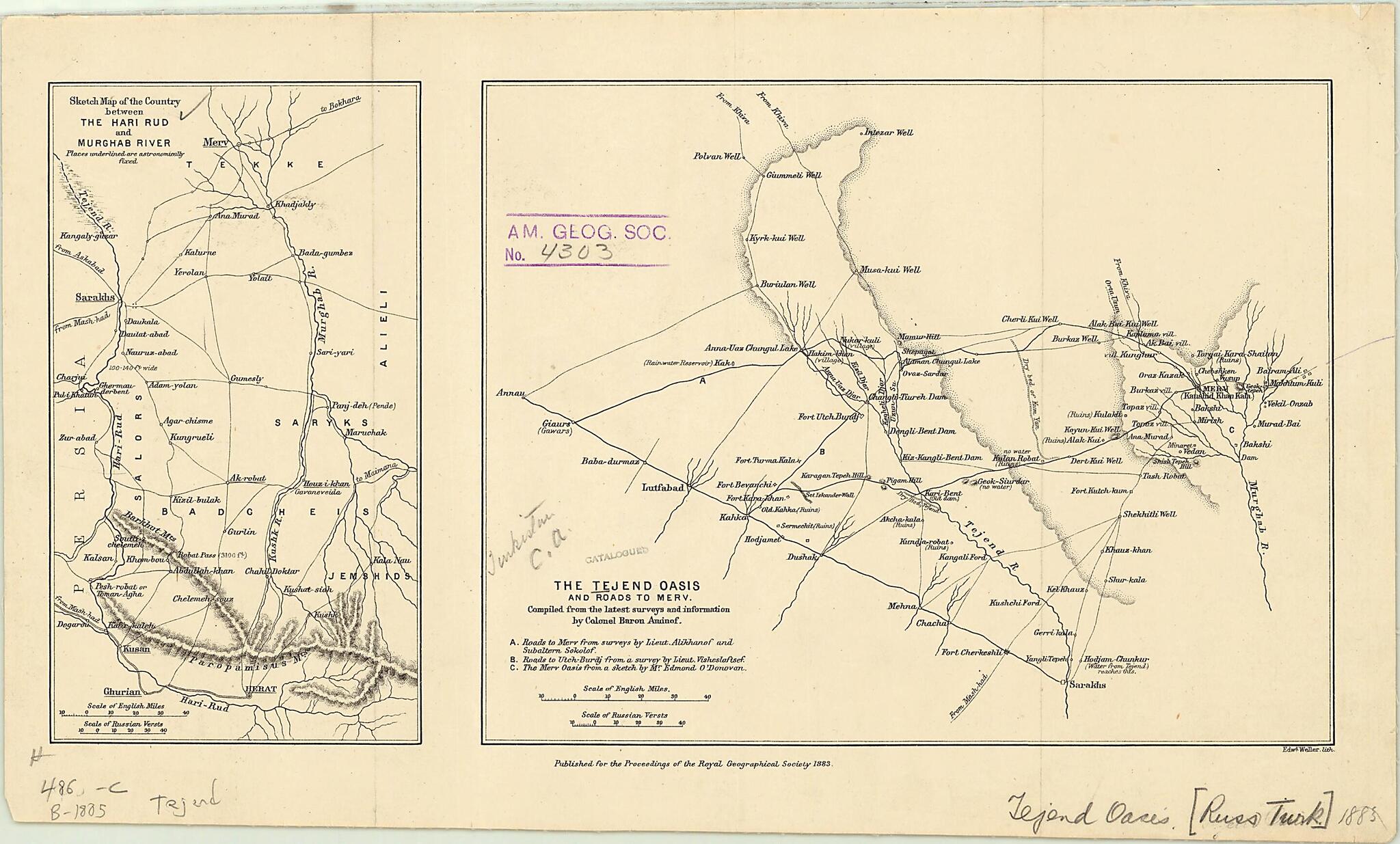
Sketch Map of the Country Between the Hari Rud and Murghab River. the Tejend Oasis and Roads to Merv 1883
- Regular price
-
$49.95 - Regular price
-
$34.95 - Sale price
-
$49.95
Buy one map, get any other map in our collection for 50% OFF! Add to cart to see discount.
Couldn't load pickup availability
About This Map
Discover the timeless beauty of our fine art quality printed reproduction of this antique map. Perfect for history enthusiasts, collectors, and interior decorators.
Restored with meticulous attention to detail by our team with over a decade of experience, this stunning reproduction captures the intricate artistry and historical significance of the original map.
Whether you're a collector or seeking a unique decor piece, this archival-quality map reproduction is a timeless addition to any space. Order now to bring history to life!
Old map of Afghanistan, Turkmenistan, Uzbekistan.day Gökdepe) in 1881, and the conquest of Merv (present-day Mary) in 1884. This 1883 map depicts roads, rivers, and topographic information relating to the region adjacent to the Tejend (or Tejen) oasis as well as the Merv oasis, some 130 kilometers to the east. Geok Tepe and the nearby city of Ashgabat do not fall within the confines of the map (lying approximately 325 kilometers to the east of Merv). Subsequent to the campaign against Geok Tepe and prior to its annexation of Merv, Russia claimed control over the sparsely populated Tejend oasis area. Some of the survivors of the massacre that followed the conquest of Geok Tepe had found their way to the Tejend area and were living in the previously uninhabited oasis. In contrast to the conquest of Geok Tepe, the conquest of Merv was based on a ruse, rather than heavy fighting. It was aided by a native of Dagestan (Daghestan in Persian), a certain Lieutenant Alikhanov. Alikhanov, whose survey data from Tejend are included in the present map, posed as a merchant, and initiated a trading agreement with Merv. In early 1884, he managed to secure the capitulation of the oasis through oratory and warnings about heavy Russian reprisals in the event of resistance on the part of the local population. Other cartographic details included in the map were gathered by Lieutenant Colonel Baron Aminof, Lieutenant Visheslaftsef, and Mr. Edmond O'Donovan. The distance scales are given in miles and versts. The map was lithographed by Edward Weller and published in the Proceedings of the Royal Geographical Society in 1883.
Created by Baron Aminof, Edmund O'Donovan, Royal Geographical Society (Great Britain), Edward Weller in 1883.
- Title devised, in English, by Library staff.
- "Scale 1:1,700,000"--Note extracted from World Digital Library.
- Original resource extent: 2 maps on 1 sheet ; 24 x 41 centimeters.
- Original resource at: University of Wisconsin-Milwaukee Libraries.
- Content in English.
- Description based on data extracted from World Digital Library, which may be extracted from partner institutions.
Map Subjects
Afghanistan
Expeditions And Surveys
Hari Rud (Afghanistan)
Library Of Congress Afghanistan Project
Murgab River (Afghanistan And Turkmenistan)
Turkmenistan
Uzbekistan
Baron Aminof
Edmund O'Donovan
Royal Geographical Society (Great Britain)
Edward Weller
1883
- For the best legibility, order your map in the original size or larger. Most maps have intricate detail and small text that is best appreciated when the print size hasn't been reduced.
- Sizes labeled "Fits a Standard Frame" will drop right into any frame that you purchase in that size. The sizes that we offer are commonly available online and at most retail stores.
- Our standard sizes are recommendations based on the aspect ratio of the original map, but still may require some added "white space" in one dimension to fit.
- Non-standard sizes will require custom framing, and we suggest taking your print to the frame shop of your choice after you receive it for the best results.
- Custom sizes are available, simply contact us for a quote.
Below is an approximation of the scale of a few standard sizes, and how they might appear in your space.
