
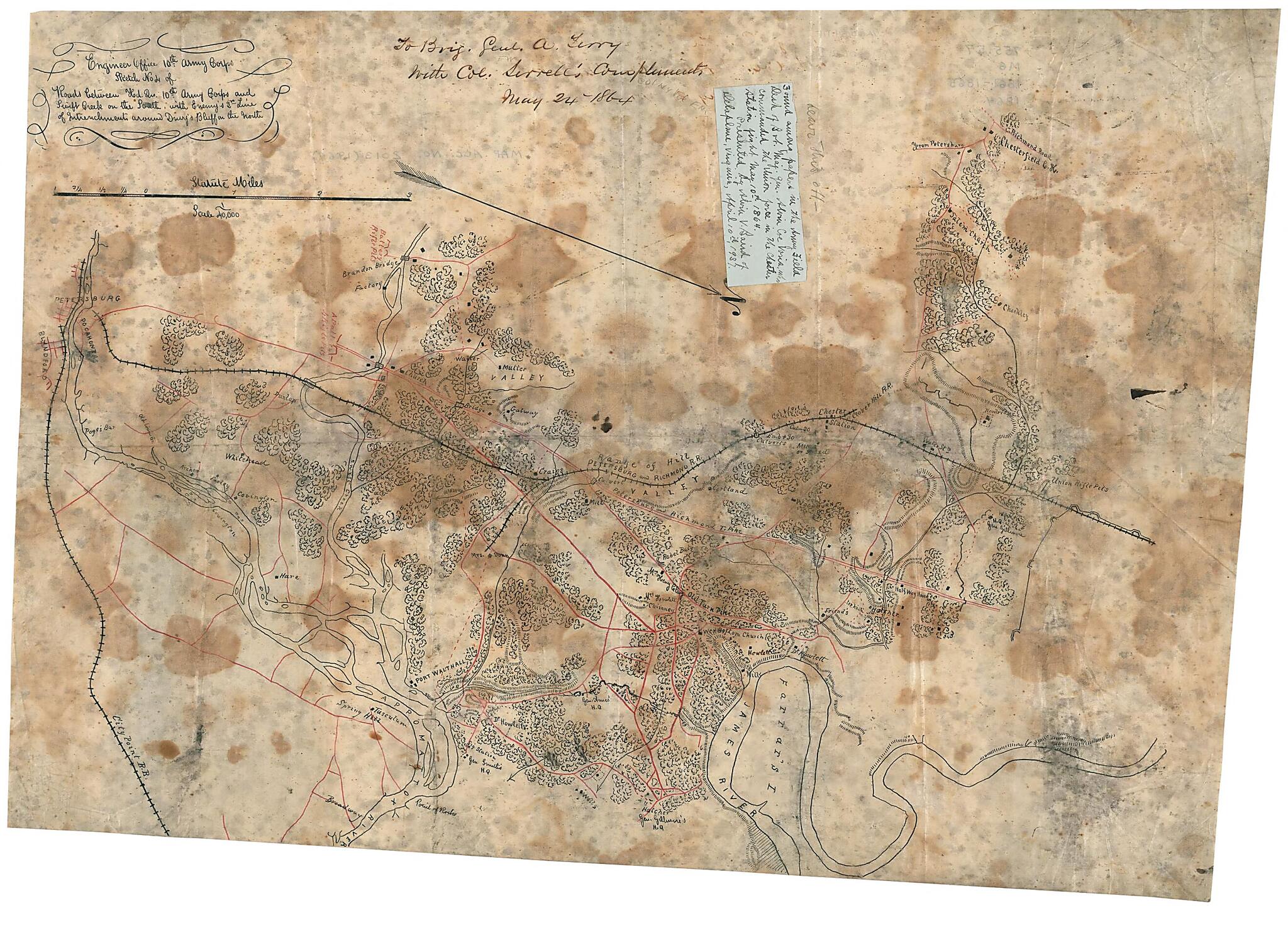
Sketch No. 4 of Roads Between Hd. Qu. 10th Army Corps and Swift Creek On the South : With Enemy's 2nd Line of Intrenchments Around Drury's Bluff On the North 1864
- Regular price
-
$54.95 - Regular price
-
$38.95 - Sale price
-
$54.95
Buy one map, get any other map in our collection for 50% OFF! Add to cart to see discount.
Couldn't load pickup availability
About This Map
Discover the timeless beauty of our fine art quality printed reproduction of this antique map. Perfect for history enthusiasts, collectors, and interior decorators.
Restored with meticulous attention to detail by our team with over a decade of experience, this stunning reproduction captures the intricate artistry and historical significance of the original map.
Whether you're a collector or seeking a unique decor piece, this archival-quality map reproduction is a timeless addition to any space. Order now to bring history to life!
Old map of Chesterfield County, Petersburg, Petersburg Region, United States, Virginia.Created by 10th. Engineer Office United States. Army. Corps in 1864.
- "To Brig. Gen. A. Terry, with Col. Serrell's complements, May 24th, 1864."
- Description derived from published bibliography.
- Includes handwritten note pasted to map: "Found among papers in the army field desk of Pvt. Maj. Gen. Alvin Coe Voris, who commanded the Union force in the Chester Station fight, May 10th, 1864. Presented by Alvia V. Baird of Delaplane, Virginia, April 10th 1937."
- Oriented with north toward the lower right.
- Pen and ink manuscript map of eastern Chesterfield County, Virginia, north of Petersburg showing Civil War fortifications, batteries, headquarters, roads, railroads, settlements, farms with occupants' names, vegetation, and streams.
- Relief shown by hachures.
- This item is in the Map Collection of the Library of Virginia; please contact the Library's Archives Research Services department for more information.
- C. 1, Dec. 1964, Conservation Commission map collection; c. 2, source unknown; c. 3, source unknown, c. 4 photocopy, LVA; March 2004, Map Cataloging Team.
- Civil War project no.: lva00184.
- Copy 2 is a manuscript tracing of copy 1; copy 3 is a photocopy of copy 2.
- Digital image available: 21.25 x 17 in.
- Previously filed as: 755.57 M6 1861-1865 1864.
Map Subjects
Chesterfield County
Chesterfield County (Va.)
Civil War
History
Maps Manuscript
Petersburg
Petersburg Region (Va.)
United States
Virginia
Petersburg Region
10th. Engineer Office United States. Army. Corps
1864
- For the best legibility, order your map in the original size or larger. Most maps have intricate detail and small text that is best appreciated when the print size hasn't been reduced.
- Sizes labeled "Fits a Standard Frame" will drop right into any frame that you purchase in that size. The sizes that we offer are commonly available online and at most retail stores.
- Our standard sizes are recommendations based on the aspect ratio of the original map, but still may require some added "white space" in one dimension to fit.
- Non-standard sizes will require custom framing, and we suggest taking your print to the frame shop of your choice after you receive it for the best results.
- Custom sizes are available, simply contact us for a quote.
Below is an approximation of the scale of a few standard sizes, and how they might appear in your space.

