
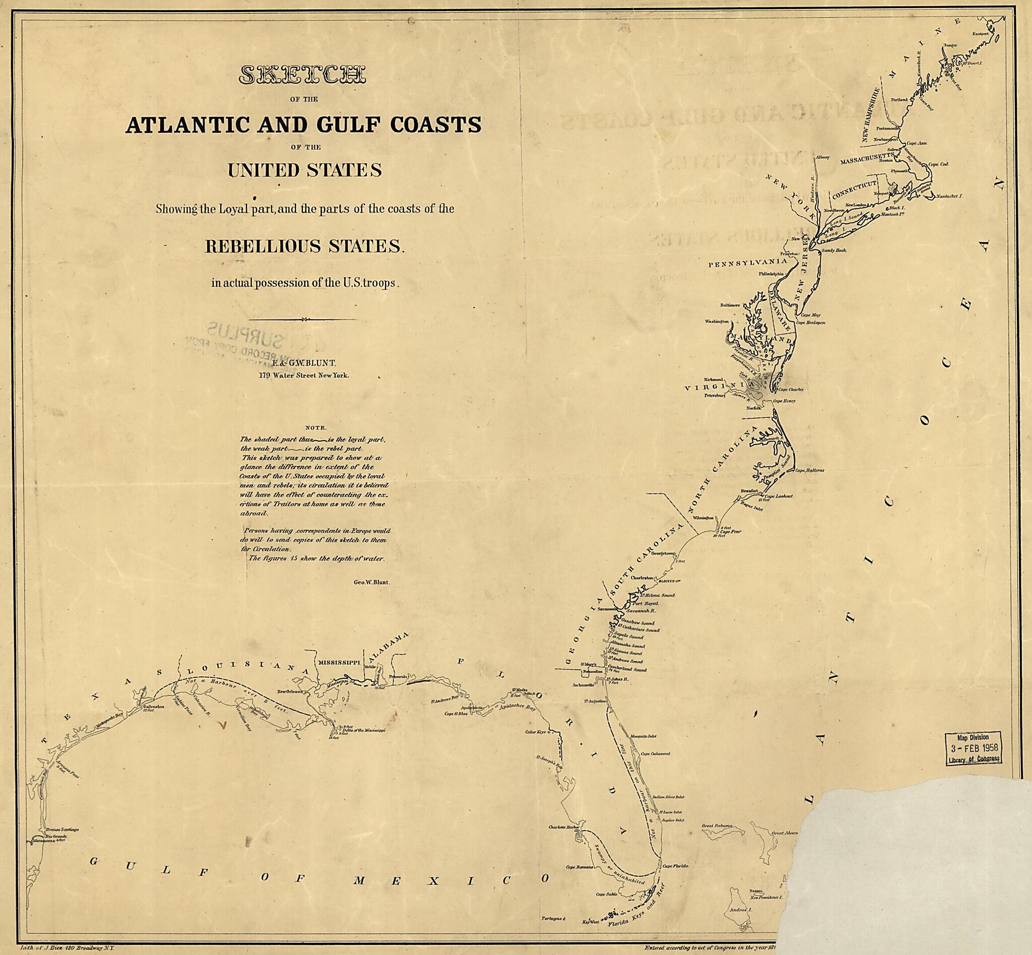
Sketch of the Atlantic and Gulf Coasts of the United States Showing the Loyal Part, and the Parts of the Coasts of the Rebellious States In Actual Possession of the U. S. Troops 1862
- Regular price
-
$51.95 - Regular price
-
$46.95 - Sale price
-
$51.95
Buy one map, get any other map in our collection for 50% OFF! Add to cart to see discount.
Couldn't load pickup availability
About This Map
Discover the timeless beauty of our fine art quality printed reproduction of this antique map. Perfect for history enthusiasts, collectors, and interior decorators.
Restored with meticulous attention to detail by our team with over a decade of experience, this stunning reproduction captures the intricate artistry and historical significance of the original map.
Whether you're a collector or seeking a unique decor piece, this archival-quality map reproduction is a timeless addition to any space. Order now to bring history to life!
Old map of Atlantic Coast, Gulf Coast, United States.Created by Edmund Blunt, G. W. (George William) Blunt in 1862.
- Scale not given.
- Civil War Map
- Lower right corner of the copy is wanting.
- "This sketch was prepared to show at a glance the difference in extent of the coasts of the U. States occupied by the loyal men and rebels; its circulation it is believed will have the effect of counteracting the exertions of traitors at home as well as those abroad. Persons having correspondents in Europe would do well to send copies of this sketch to them for circulation. The figures ... show the depth of water. Geo. W. Blunt."
- "Loyal part" of the coast is distinguished by a heavy line and the "rebel part" by a thin line.
- Principal coastal features are named.
- Description derived from published bibliography.
Map Subjects
Atlantic Coast
Atlantic Coast (U.S.)
Coasts
Gulf Coast
Gulf Coast (U.S.)
United States
Edmund Blunt
G. W. (George William) Blunt
1862
- For the best legibility, order your map in the original size or larger. Most maps have intricate detail and small text that is best appreciated when the print size hasn't been reduced.
- Sizes labeled "Fits a Standard Frame" will drop right into any frame that you purchase in that size. The sizes that we offer are commonly available online and at most retail stores.
- Our standard sizes are recommendations based on the aspect ratio of the original map, but still may require some added "white space" in one dimension to fit.
- Non-standard sizes will require custom framing, and we suggest taking your print to the frame shop of your choice after you receive it for the best results.
- Custom sizes are available, simply contact us for a quote.
Below is an approximation of the scale of a few standard sizes, and how they might appear in your space.

