
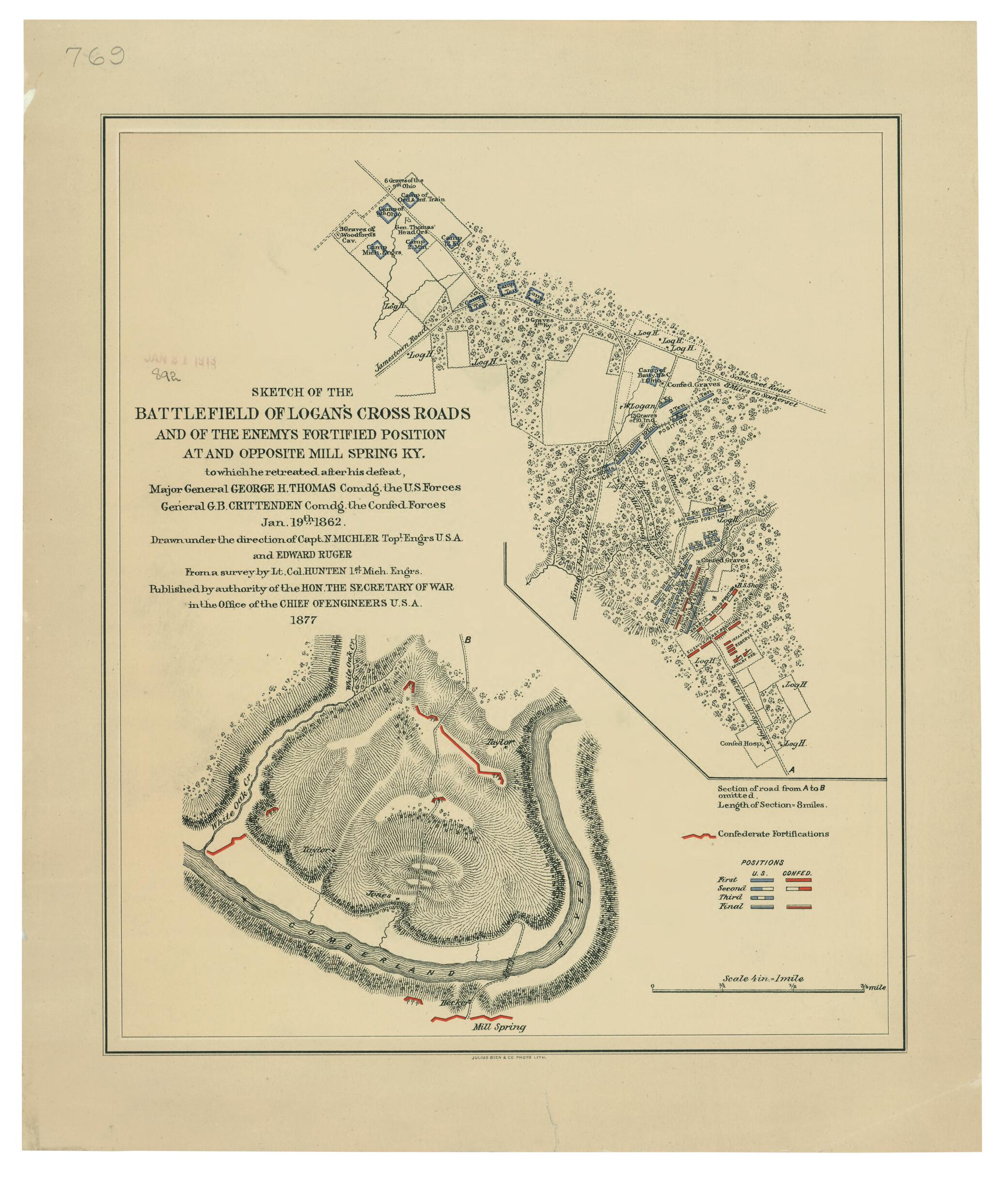
Sketch of the Battlefield of Logan's Cross Roads and of the Enemys Fortified Position at and Opposite Mill Spring, Ky. to Which He Retreated After His Defeat, Major General George H. Thomas Comdg. the U.S. Forces, General G.B. Crittenden Comdg. the Co...
- Regular price
-
$49.95 - Regular price
-
$34.95 - Sale price
-
$49.95
Buy one map, get any other map in our collection for 50% OFF! Add to cart to see discount.
Couldn't load pickup availability
About This Map
Discover the timeless beauty of our fine art quality printed reproduction of this antique map. Perfect for history enthusiasts, collectors, and interior decorators.
Restored with meticulous attention to detail by our team with over a decade of experience, this stunning reproduction captures the intricate artistry and historical significance of the original map.
Whether you're a collector or seeking a unique decor piece, this archival-quality map reproduction is a timeless addition to any space. Order now to bring history to life!
Old map of Kentucky, Mill Springs, United States.Created by Julius Bien & Co., N. (Nathaniel) Michler, Edward Ruger, United States. Army. Corps of Engineers in 1877.
- "Julius Bien & Co., Photo Lith."
- Description derived from published bibliography.
- Map of Logan's Cross Roads indicates four positions of Union and Confederate soldiers, troop camps, location of graves, roads, drainage, vegetation, houses, fences, and a few hachures.
- Map of Mill Spring shows Confederate entrenchments, roads, drainage, vegetation, hachures, houses and the names of residents. Eight-mile stretch of road between Longan's Cross Roads and Mill Spring is not shown.
- This item is in the Map Collection of the Library of Virginia; please contact the Library's Archives Research Services department for more information.
- Civil War Map
- Jan. 1913, Libbie, b; April 2004, Map Cataloging Team.
- Civil War project no.: lva00201.
- Conservation: Etherington Conservation Center, April 2004.
- Digital image available: 16 x 13.5 in.
- Map accession no. 892 (1913).
- For the best legibility, order your map in the original size or larger. Most maps have intricate detail and small text that is best appreciated when the print size hasn't been reduced.
- Sizes labeled "Fits a Standard Frame" will drop right into any frame that you purchase in that size. The sizes that we offer are commonly available online and at most retail stores.
- Our standard sizes are recommendations based on the aspect ratio of the original map, but still may require some added "white space" in one dimension to fit.
- Non-standard sizes will require custom framing, and we suggest taking your print to the frame shop of your choice after you receive it for the best results.
- Custom sizes are available, simply contact us for a quote.
Below is an approximation of the scale of a few standard sizes, and how they might appear in your space.

