
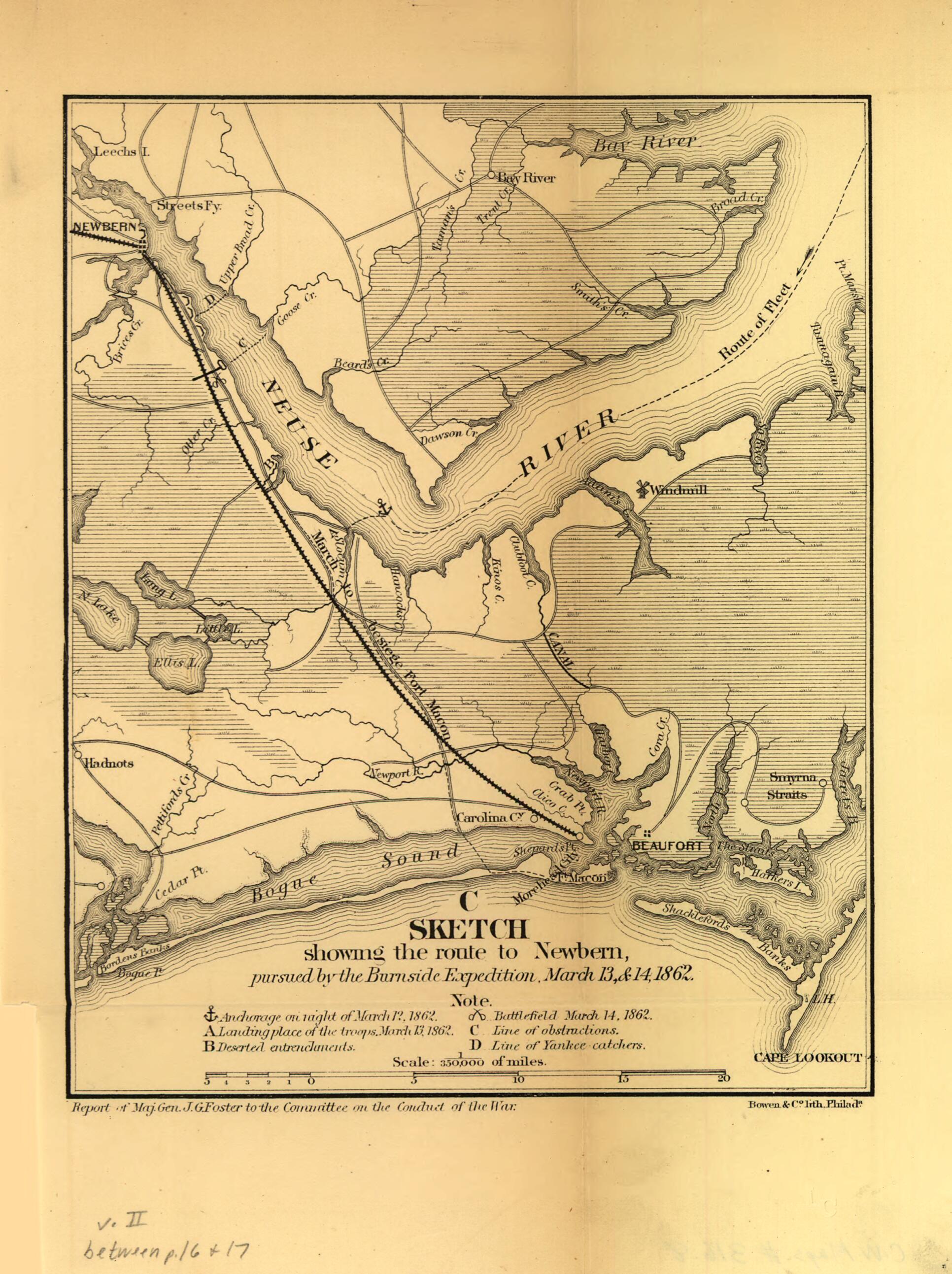
Sketch Showing the Route to Newbern, Pursued by the Burnside Expedition, March 13 & 14, 1862 in 1866
- Regular price
-
$49.95 - Regular price
-
$29.95 - Sale price
-
$49.95
Buy one map, get any other map in our collection for 50% OFF! Add to cart to see discount.
Couldn't load pickup availability
About This Map
Discover the timeless beauty of our fine art quality printed reproduction of this antique map. Perfect for history enthusiasts, collectors, and interior decorators.
Restored with meticulous attention to detail by our team with over a decade of experience, this stunning reproduction captures the intricate artistry and historical significance of the original map.
Whether you're a collector or seeking a unique decor piece, this archival-quality map reproduction is a timeless addition to any space. Order now to bring history to life!
Old map of North Carolina, United States.Created by John G. (John Gray) Foster in 1866.
- Scale 1:350,000.
- Civil War Map
- From U.S. Congress. Joint Committee on the Conduct of the War. Supplemental report of the Joint Committee on the Conduct of the War, in two volumes. Supplemental to Senate report no. 142, 38th Congress, 2d session (Washington, Government Printing Office, 1866). v. 2, fol. p. 16.
- Accompanies "Report of Major General J. G. Foster, to the Committee on the Conduct of the War." 23 p.
- At head of map title: C.
- Map shows "anchorage on night of March 12, 1862," "landing place of the troops, March 13, 1862," "deserted entrenchments," "battlefield March 14, 1862," "line of obstructions," and "line of Yankee catchers" on the Neuse River.
- Description derived from published bibliography.
- For the best legibility, order your map in the original size or larger. Most maps have intricate detail and small text that is best appreciated when the print size hasn't been reduced.
- Sizes labeled "Fits a Standard Frame" will drop right into any frame that you purchase in that size. The sizes that we offer are commonly available online and at most retail stores.
- Our standard sizes are recommendations based on the aspect ratio of the original map, but still may require some added "white space" in one dimension to fit.
- Non-standard sizes will require custom framing, and we suggest taking your print to the frame shop of your choice after you receive it for the best results.
- Custom sizes are available, simply contact us for a quote.
Below is an approximation of the scale of a few standard sizes, and how they might appear in your space.

