
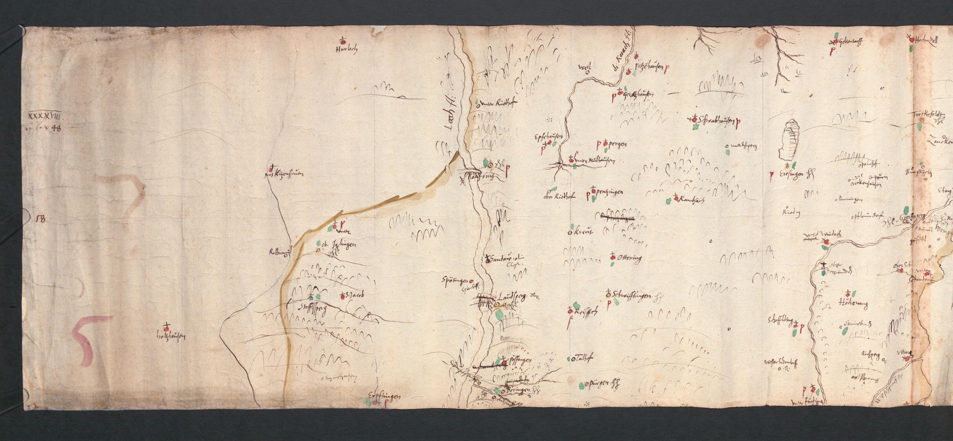
Sketches for the Great Map of Bavaria from 1563, Part 2. Topographical Map of Bavaria 47 Degrees 54 Minutes to 48 Degrees 2 Minutes North Latitude. (Vorzeichnungen Für Die Grosse Karte Bayerns Von 1563, Teil 2: Topographische Karte Von Bayern 47° 54...
- Regular price
-
$84.95 - Regular price
-
$79.95 - Sale price
-
$84.95
Buy one map, get any other map in our collection for 50% OFF! Add to cart to see discount.
Couldn't load pickup availability
About This Map
Discover the timeless beauty of our fine art quality printed reproduction of this antique map. Perfect for history enthusiasts, collectors, and interior decorators.
Restored with meticulous attention to detail by our team with over a decade of experience, this stunning reproduction captures the intricate artistry and historical significance of the original map.
Whether you're a collector or seeking a unique decor piece, this archival-quality map reproduction is a timeless addition to any space. Order now to bring history to life!
Old map of Württemberg, Bavaria, Germany.89) carried out a topographical survey of Bavaria (without using triangulation), on which was based the first mathematically measured map of a large region. In 1563, he completed a large-scale version on vellum, to a scale of 1:40,000, which was unfortunately destroyed after 1720. A copy of the original that was produced by 1756 also was destroyed in the Second World War. However, the manuscript sketches to this "Great Map of Bavaria" survived, and nowadays are divided into seven scrolls with the numbering of the parts from south to north. The one presented here was produced in Ingolstadt in 1554 or 1555, at the very beginning of Apian's work, and deals with the section from 47° 54' to 48° 2' north latitude. At the request of the duke, Apian reduced the scale to 1:145,000 and prepared the map for woodblock printing. Jost Amman undertook the artwork for the borders and cartouches. This second version was issued in 1568 and remained the official map of Bavaria until the 19th century. In the course of his surveying work, Apian also collected material for a Descriptio Bavariae (description of Bavaria) and had views of castles, settlements, and landscapes prepared for the work. His death, however, in 1589 prevented the printing of the work, which was to have combined the maps with an illustrated description of the country. Duke Wilhelm V of Bavaria bought both the unpublished manuscript and the aforementioned seven scrolls of 1554-55 for 1,000 gulden, which then came to his court library in Munich, the forerunner of the Bavarian State Library, where these works have been part of the collections ever since.
Created by Duke of Bavaria Albrecht V, Philippus Apianus in 1554.
- Title devised, in English, by Library staff.
- "This description of the work was written by Traudl Seifert.|BSB shelfmark: Cod.icon. 142(2"--Note extracted from World Digital Library.
- Original resource extent: 1 map of 10 folios, paper ; 30-33 x 462 centimeters.
- Original resource at: Bavarian State Library.
- Content in German.
- Description based on data extracted from World Digital Library, which may be extracted from partner institutions.
- For the best legibility, order your map in the original size or larger. Most maps have intricate detail and small text that is best appreciated when the print size hasn't been reduced.
- Sizes labeled "Fits a Standard Frame" will drop right into any frame that you purchase in that size. The sizes that we offer are commonly available online and at most retail stores.
- Our standard sizes are recommendations based on the aspect ratio of the original map, but still may require some added "white space" in one dimension to fit.
- Non-standard sizes will require custom framing, and we suggest taking your print to the frame shop of your choice after you receive it for the best results.
- Custom sizes are available, simply contact us for a quote.
Below is an approximation of the scale of a few standard sizes, and how they might appear in your space.
