
Southwest Arabia: Ebha, Sheet 4. (S.W. Arabia: Ebha, Sheet 4) 1917
- Regular price
-
$83.95 - Regular price
-
$78.95 - Sale price
-
$83.95
Buy one map, get any other map in our collection for 50% OFF! Add to cart to see discount.
Couldn't load pickup availability
About This Map
Discover the timeless beauty of our fine art quality printed reproduction of this antique map. Perfect for history enthusiasts, collectors, and interior decorators.
Restored with meticulous attention to detail by our team with over a decade of experience, this stunning reproduction captures the intricate artistry and historical significance of the original map.
Whether you're a collector or seeking a unique decor piece, this archival-quality map reproduction is a timeless addition to any space. Order now to bring history to life!
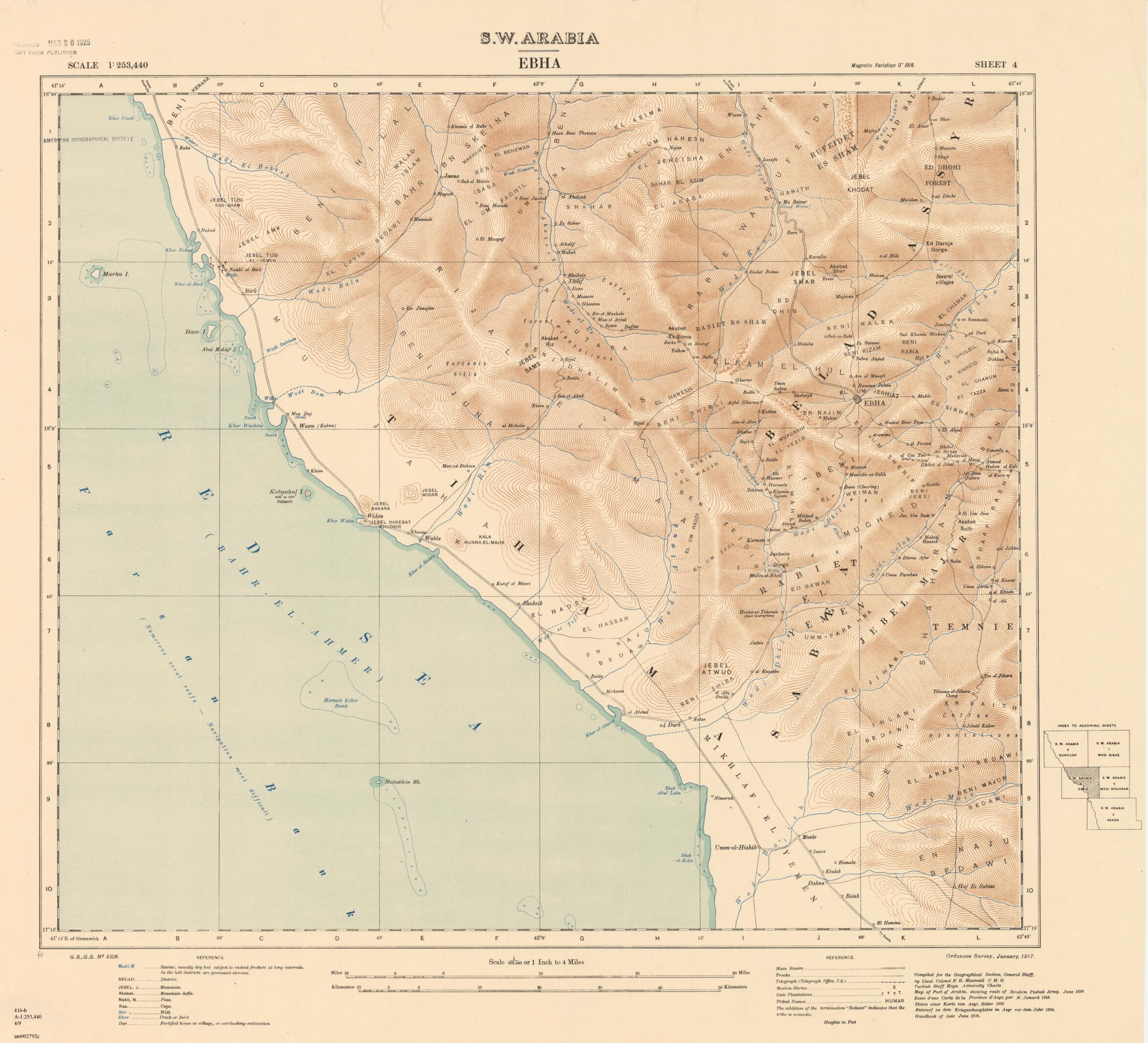
Old map of `asīr, Abha, Saudi Arabia.scale depictions of the southwestern portion of the Arabian Peninsula. It was published by the British Ordnance Survey in cooperation with the Geographical Section of the General Staff at the War Office, which published the series of maps of the peninsula covering Ta'izz, Mecca, Taʼif, Kunfuda (or al-Qunfudhah), Wadi Bishah, Abha, Wadi Shehran, Saada, and Sanaʻa. The map covers the area around the city of Ebha (present-day Abha, Saudi Arabia). It shows the Red Sea coast and the thinly settled upland areas bordering the higher ranges to the south. Much of the Arabian Peninsula was part of the Ottoman Empire. Although most British military and political efforts in the early 20th century were concentrated towards the north, the entire region was caught up in the British campaign in World War I to wrest the Middle East from the Ottomans. The map was designed by army intelligence officer and traveler Francis Richard Maunsell (1861-1929). Maunsell had earlier explored and mapped the eastern portions of Anatolia and the adjacent areas of Syria, Iraq, and Iran. His reports were held closely by the government, but parts were published in his 1901 article "Central Kurdistan" in The Geographical Journal. He was also an accomplished photographer and produced dramatic photographs during his Arabian travels. It is not clear how much of southwestern Arabia he himself knew. Notes list several sources for Maunsell's cartography, including French and German maps and even Turkish Admiralty charts.
Created by Great Britain. War Office. General Staff. Geographical Section, Francis Richard Maunsell in 1917.
- Title devised, in English, by Library staff.
- "Scale 1:253,440"--Note extracted from World Digital Library.
- Original resource extent: 1 map (sheet 4 of 9) : color ; on sheet 78 x 102 centimeters or smaller.
- Original resource at: University of Wisconsin-Milwaukee Libraries.
- Content in English.
- Description based on data extracted from World Digital Library, which may be extracted from partner institutions.
- For the best legibility, order your map in the original size or larger. Most maps have intricate detail and small text that is best appreciated when the print size hasn't been reduced.
- Sizes labeled "Fits a Standard Frame" will drop right into any frame that you purchase in that size. The sizes that we offer are commonly available online and at most retail stores.
- Our standard sizes are recommendations based on the aspect ratio of the original map, but still may require some added "white space" in one dimension to fit.
- Non-standard sizes will require custom framing, and we suggest taking your print to the frame shop of your choice after you receive it for the best results.
- Custom sizes are available, simply contact us for a quote.
Below is an approximation of the scale of a few standard sizes, and how they might appear in your space.

