
Southwest Arabia: Mecca, Sheet 8. (S.W. Arabia: Mecca, Sheet 8) 1917
- Regular price
-
$108.95 - Regular price
-
$103.95 - Sale price
-
$108.95
Buy one map, get any other map in our collection for 50% OFF! Add to cart to see discount.
Couldn't load pickup availability
About This Map
Discover the timeless beauty of our fine art quality printed reproduction of this antique map. Perfect for history enthusiasts, collectors, and interior decorators.
Restored with meticulous attention to detail by our team with over a decade of experience, this stunning reproduction captures the intricate artistry and historical significance of the original map.
Whether you're a collector or seeking a unique decor piece, this archival-quality map reproduction is a timeless addition to any space. Order now to bring history to life!
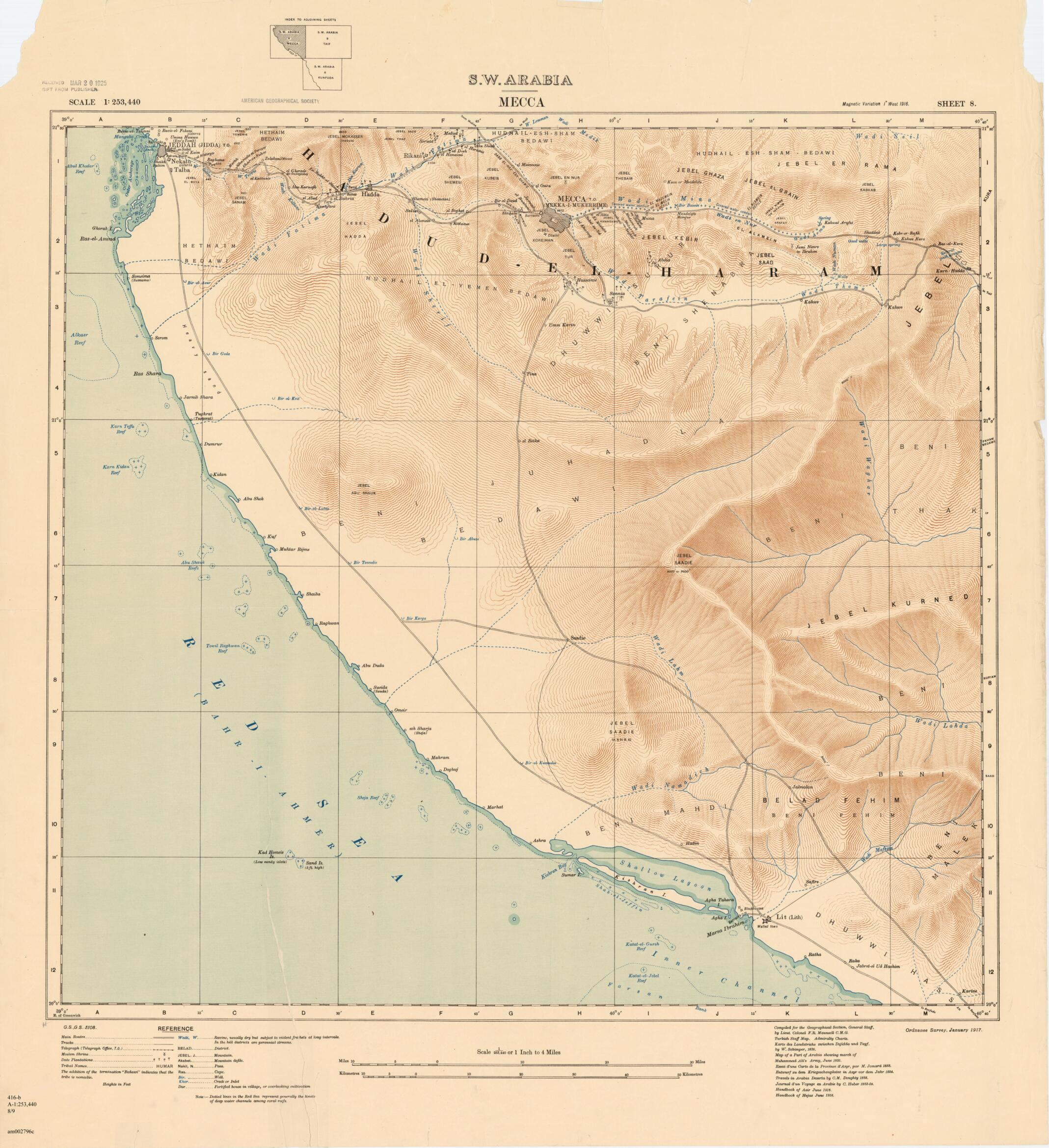
Old map of Makkah, Mecca, Saudi Arabia.scale depictions of the southwestern portion of the Arabian Peninsula. The map covers the region from Mecca and its port of Jeddah (now Jiddah) in the north to the southern town of al-Līth on the Red Sea and the arid areas towards the southwest. The entire region is known as Hijaz, or Hejaz. Much of the Arabian Peninsula was part of the Ottoman Empire, and Mecca played a crucial role in the British campaign to wrest the entire Middle East from Ottoman control during the First World War. It was in Mecca that Sharif Husayn ibn ʻAli, ruler of the Hijaz, had his capital. In a 1915-16 exchange of correspondence with Sir Henry McMahon, Husayn formed a military alliance with the British against his Ottoman suzerain. In return, McMahon promised an independent state for the Arabs with Husayn as king, an offer that was undermined by a contradictory deal with the French in the Sykes-Picot Agreement of 1916. The consequences of these diplomatic and political maneuvers laid the foundations for today's alignment of states in the Middle East. The map was created by the British Ordnance Survey in cooperation with the Geographical Section of the General Staff at the War Office, which published the series of maps of the southwestern peninsula covering Ta'izz, Mecca, Taʼif, Kunfuda (or al-Qunfudhah), Wadi Bishah, Abha, Wadi Shehran, Saada, and Sanaʻa. The geography and ethnography is the product of research by Francis Richard Maunsell (1861-1929), a British army intelligence officer, traveler, and mapmaker. Maunsell's listed sources date from 1824-1916 and include a Turkish staff map, Admiralty charts, and German, French, and British works. There is a small glossary of Arabic topographical terms. Distance scales are given in kilometers and miles, and relief is indicated by contour lines and spot elevations in feet.
Created by Great Britain. War Office. General Staff. Geographical Section, Francis Richard Maunsell in 1917.
- Title devised, in English, by Library staff.
- "Scale 1:253,440"--Note extracted from World Digital Library.
- Original resource extent: 1 map (sheet 8 of 9) : color ; on sheet 78 x 102 centimeters or smaller.
- Original resource at: University of Wisconsin-Milwaukee Libraries.
- Content in English.
- Description based on data extracted from World Digital Library, which may be extracted from partner institutions.
- For the best legibility, order your map in the original size or larger. Most maps have intricate detail and small text that is best appreciated when the print size hasn't been reduced.
- Sizes labeled "Fits a Standard Frame" will drop right into any frame that you purchase in that size. The sizes that we offer are commonly available online and at most retail stores.
- Our standard sizes are recommendations based on the aspect ratio of the original map, but still may require some added "white space" in one dimension to fit.
- Non-standard sizes will require custom framing, and we suggest taking your print to the frame shop of your choice after you receive it for the best results.
- Custom sizes are available, simply contact us for a quote.
Below is an approximation of the scale of a few standard sizes, and how they might appear in your space.

