
Southwest Arabia: Taiz, Sheet 1. (S.W. Arabia: Taiz, Sheet 1) 1916
- Regular price
-
$117.95 - Regular price
-
$112.95 - Sale price
-
$117.95
Buy one map, get any other map in our collection for 50% OFF! Add to cart to see discount.
Couldn't load pickup availability
About This Map
Discover the timeless beauty of our fine art quality printed reproduction of this antique map. Perfect for history enthusiasts, collectors, and interior decorators.
Restored with meticulous attention to detail by our team with over a decade of experience, this stunning reproduction captures the intricate artistry and historical significance of the original map.
Whether you're a collector or seeking a unique decor piece, this archival-quality map reproduction is a timeless addition to any space. Order now to bring history to life!
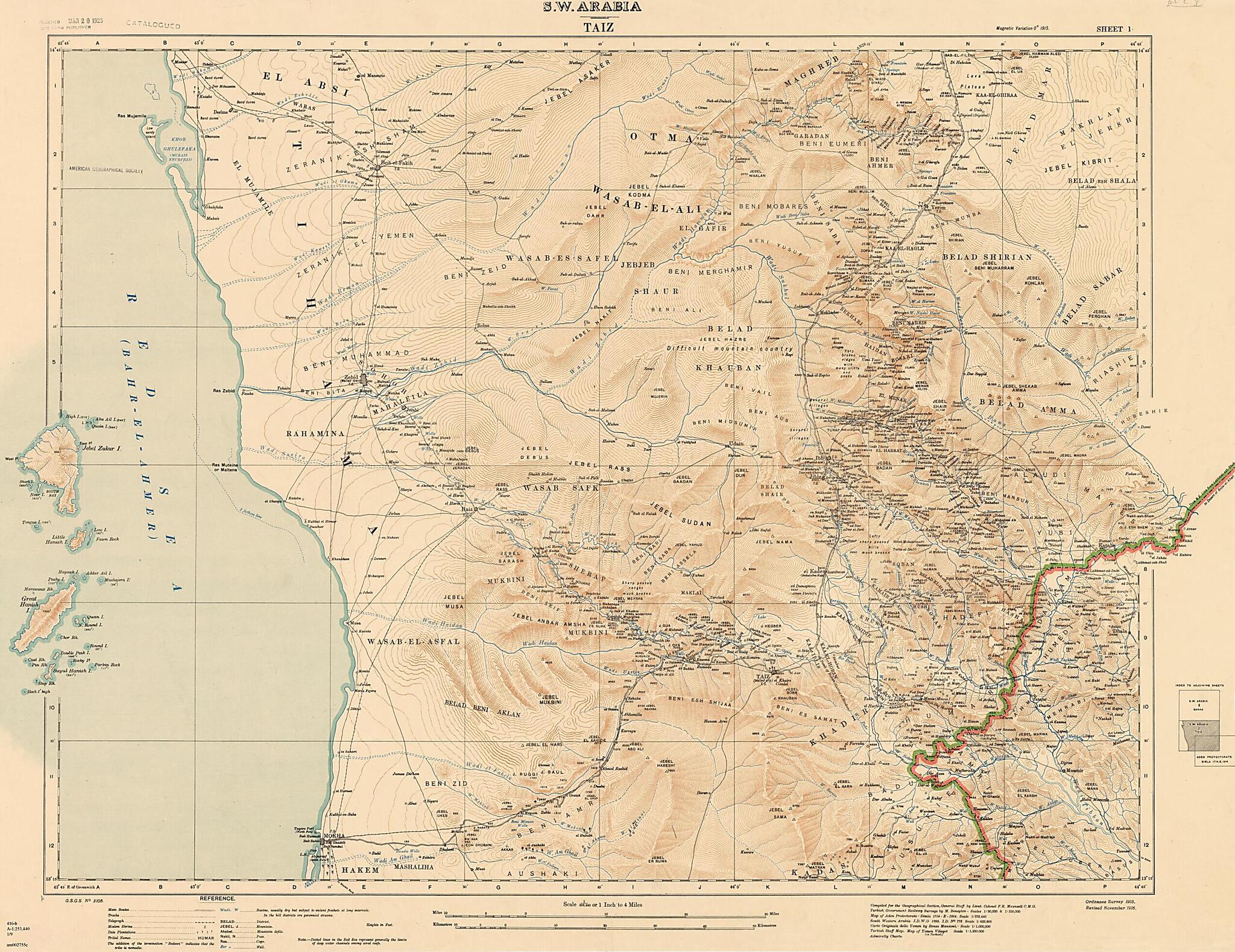
Old map of Tā'izz, Yemen.day Republic of Yemen. The large scale allows for the display of detail about cities and towns, tribes, topographical features, and the inclusion of notes with information not often found on earlier maps of the region. The map covers the sparsely populated mountains in the north to the southern port of Mokha (or Mocha). The broad coastal plain along the Red Sea known as the Tihama is depicted as a thinly populated strand with roads or tracks ascending to the walled towns of Taiz (now Taʻizz) and Ibb in the highlands. Much of the Arabian Peninsula, including present-day Yemen, was part of the Ottoman Empire. Although most British military and political efforts in the early 20th century were concentrated towards the north, the entire region was caught up in the British campaign in World War I to wrest the Middle East from the Ottomans. A version of this map was first published in 1915. The copy shown here is a 1916 revision. Numbers on the map refer to elevations in feet. The map was created by the British Ordnance Survey in cooperation with the Geographical Section of the General Staff at the War Office, which published a series of nine maps of the peninsula covering Ta'izz, Mecca, Taʼif, Kunfuda (or al-Qunfudhah), Wadi Bishah, Abha, Wadi Shehran, Saada, and Sanaʻa. The cartography and ethnography is the product of research by Francis Richard Maunsell (1861-1929), a British army intelligence officer, traveler, and mapmaker.
Created by Great Britain. War Office. General Staff. Geographical Section, Francis Richard Maunsell in 1916.
- Title devised, in English, by Library staff.
- "Scale 1:253,440"--Note extracted from World Digital Library.
- Original resource extent: 1 map (1 of 9 sheets) : color ; on sheet 78 x 102 centimeters or smaller.
- Original resource at: University of Wisconsin-Milwaukee Libraries.
- Content in English.
- Description based on data extracted from World Digital Library, which may be extracted from partner institutions.
Map Subjects
Arabian Peninsula
Red Sea
Tā'izz
World War
Yemen
Great Britain. War Office. General Staff. Geographical Section
Francis Richard Maunsell
1916
- For the best legibility, order your map in the original size or larger. Most maps have intricate detail and small text that is best appreciated when the print size hasn't been reduced.
- Sizes labeled "Fits a Standard Frame" will drop right into any frame that you purchase in that size. The sizes that we offer are commonly available online and at most retail stores.
- Our standard sizes are recommendations based on the aspect ratio of the original map, but still may require some added "white space" in one dimension to fit.
- Non-standard sizes will require custom framing, and we suggest taking your print to the frame shop of your choice after you receive it for the best results.
- Custom sizes are available, simply contact us for a quote.
Below is an approximation of the scale of a few standard sizes, and how they might appear in your space.

