
Stockholm 1870
- Regular price
-
$49.95 - Regular price
-
$34.95 - Sale price
-
$49.95
Buy one map, get any other map in our collection for 50% OFF! Add to cart to see discount.
Couldn't load pickup availability
About This Map
Discover the timeless beauty of our fine art quality printed reproduction of this antique map. Perfect for history enthusiasts, collectors, and interior decorators.
Restored with meticulous attention to detail by our team with over a decade of experience, this stunning reproduction captures the intricate artistry and historical significance of the original map.
Whether you're a collector or seeking a unique decor piece, this archival-quality map reproduction is a timeless addition to any space. Order now to bring history to life!
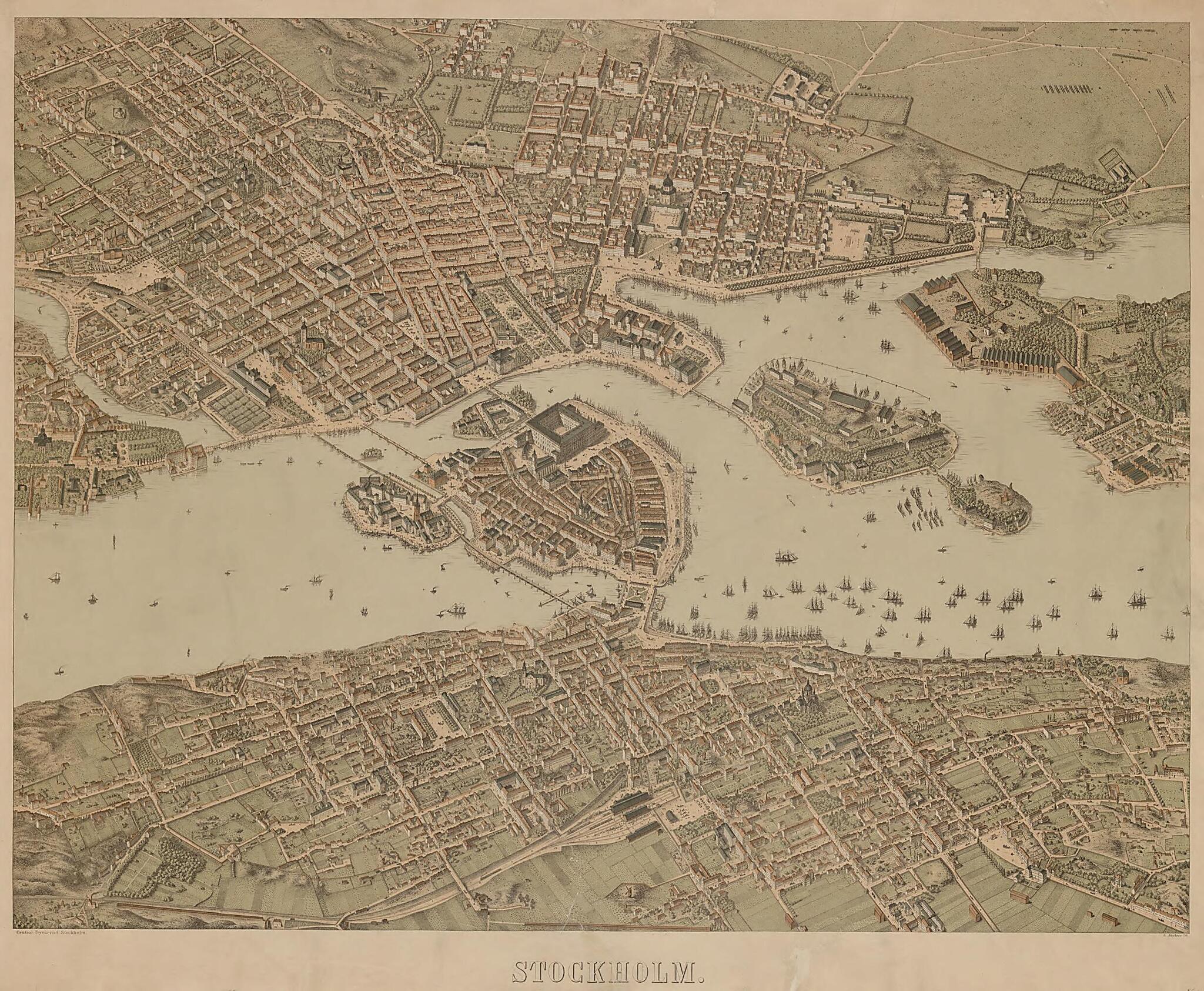
Old map of Stockholm, Stockholm County, Sweden.-87) was a German-born map maker and lithographer who worked in Sweden for many years. His largest and best-known work is this panoramic map of Stockholm, which he created in the 1870s using an oblique image in isometric perspective. The buildings on the map are depicted with remarkable accuracy. Neuhaus is reported to have said that in order to produce the map, he walked through every neighborhood of the city and sketched the exterior of its buildings and other structures. The map captures the rapid growth of Stockholm that was characteristic of major European cities in the second half of the 19th century. Neuhaus made maps in a similarly three-dimensional style of the Stockholm districts of Norrmalm, Sodermalm, and Ostermalm.
Created by Heinrich Neuhaus in 1870.
- Title devised, in English, by Library staff.
- Original resource extent: 1 print : litography ; 57 x 74 centimeters.
- Original resource at: National Library of Sweden.
- Content in Swedish.
- Description based on data extracted from World Digital Library, which may be extracted from partner institutions.
Map Subjects
Cities And Towns
Panoramic Views
Stockholm
Stockholm County
Sweden
Heinrich Neuhaus
1870
- For the best legibility, order your map in the original size or larger. Most maps have intricate detail and small text that is best appreciated when the print size hasn't been reduced.
- Sizes labeled "Fits a Standard Frame" will drop right into any frame that you purchase in that size. The sizes that we offer are commonly available online and at most retail stores.
- Our standard sizes are recommendations based on the aspect ratio of the original map, but still may require some added "white space" in one dimension to fit.
- Non-standard sizes will require custom framing, and we suggest taking your print to the frame shop of your choice after you receive it for the best results.
- Custom sizes are available, simply contact us for a quote.
Below is an approximation of the scale of a few standard sizes, and how they might appear in your space.

