
Sumatra 1556
- Regular price
-
$54.95 - Regular price
-
$38.95 - Sale price
-
$54.95
Buy one map, get any other map in our collection for 50% OFF! Add to cart to see discount.
Couldn't load pickup availability
About This Map
Discover the timeless beauty of our fine art quality printed reproduction of this antique map. Perfect for history enthusiasts, collectors, and interior decorators.
Restored with meticulous attention to detail by our team with over a decade of experience, this stunning reproduction captures the intricate artistry and historical significance of the original map.
Whether you're a collector or seeking a unique decor piece, this archival-quality map reproduction is a timeless addition to any space. Order now to bring history to life!
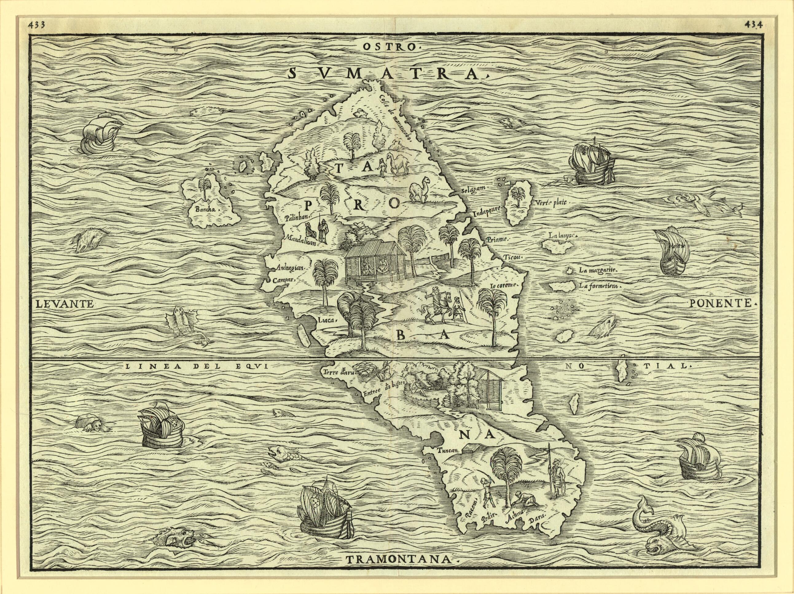
Old map of Indonesia.59. Ramusio was a Venetian diplomat, geographer, and historian. Delle Navigationi et Viaggi is a massive work that includes Ramusio's translations into Italian of many first-hand accounts of the exploration, up to the mid-16th century, of Africa, the New World, and Asia, along with maps by the Venetian cartographer Giacomo Gastaldi (circa 1500-circa 1565). The book contains an account of the voyage of the Parmentier brothers, Frenchmen who landed on the west coast of Sumatra in 1529 in defiance of the Portuguese monopoly on the spice trade in the East Indies and their blockade on foreign access to the island. Both brothers subsequently died of fever. Prior to the publication of Ramusio's map, Sumatra had been confused with Sri Lanka and maps of the island were largely conjectural, based primarily on the writings of Marco Polo. The map is oriented with south at the top. The shape of the island and many of its features are quite accurately portrayed. No part of the nearby Malay Peninsula or the island of Java is shown, although several of the surrounding small islands, such as Bancha (present-day Bangka), are displayed. The interior of the map is illustrated with scenes that depict vegetation, animals, and native figures at work and play; the surrounding seas contain ships and numerous creatures, both real and imaginary.
Created by Giacomo Gastaldi, Jean Parmentier, Raoul Parmentier, Giovanni Battista Ramusio in 1556.
- Title devised, in English, by Library staff.
- Original resource extent: 1 map ; 26 x 50 centimeters.
- Reference extracted from World Digital Library: Jerome Randall Barnes, Giovanni Battista Ramusio and the History of Discoveries: An Analysis of Ramusio's Commentary, Cartography, and Imagery in "Delle Navigationi et Viaggi," Ph.D. thesis (Arlington, Texas: The University of Texas, 2007).|Margaret Small, "Displacing Ptolemy? The Textual Geographies of Ramusio's Navigazioni e Viaggi," in Keith Lilley, editor, Mapping Medieval Geographies: Geographical Encounters in the Latin West and Beyond, 300-1600 (Cambridge, U.K., and New York: Cambridge University Press, 2013).
- Original resource at: Qatar National Library.
- Content in Italian.
- Description based on data extracted from World Digital Library, which may be extracted from partner institutions.
- For the best legibility, order your map in the original size or larger. Most maps have intricate detail and small text that is best appreciated when the print size hasn't been reduced.
- Sizes labeled "Fits a Standard Frame" will drop right into any frame that you purchase in that size. The sizes that we offer are commonly available online and at most retail stores.
- Our standard sizes are recommendations based on the aspect ratio of the original map, but still may require some added "white space" in one dimension to fit.
- Non-standard sizes will require custom framing, and we suggest taking your print to the frame shop of your choice after you receive it for the best results.
- Custom sizes are available, simply contact us for a quote.
Below is an approximation of the scale of a few standard sizes, and how they might appear in your space.

