
Tableau Des Opérations De La Grande Armée Depuis L'ouverture De La Campagne Jusqu'au 21 Aout 1812 : Eastern Europe
- Regular price
-
$49.95 - Regular price
-
$34.95 - Sale price
-
$49.95
Buy one map, get any other map in our collection for 50% OFF! Add to cart to see discount.
Couldn't load pickup availability
About This Map
Discover the timeless beauty of our fine art quality printed reproduction of this antique map. Perfect for history enthusiasts, collectors, and interior decorators.
Restored with meticulous attention to detail by our team with over a decade of experience, this stunning reproduction captures the intricate artistry and historical significance of the original map.
Whether you're a collector or seeking a unique decor piece, this archival-quality map reproduction is a timeless addition to any space. Order now to bring history to life!
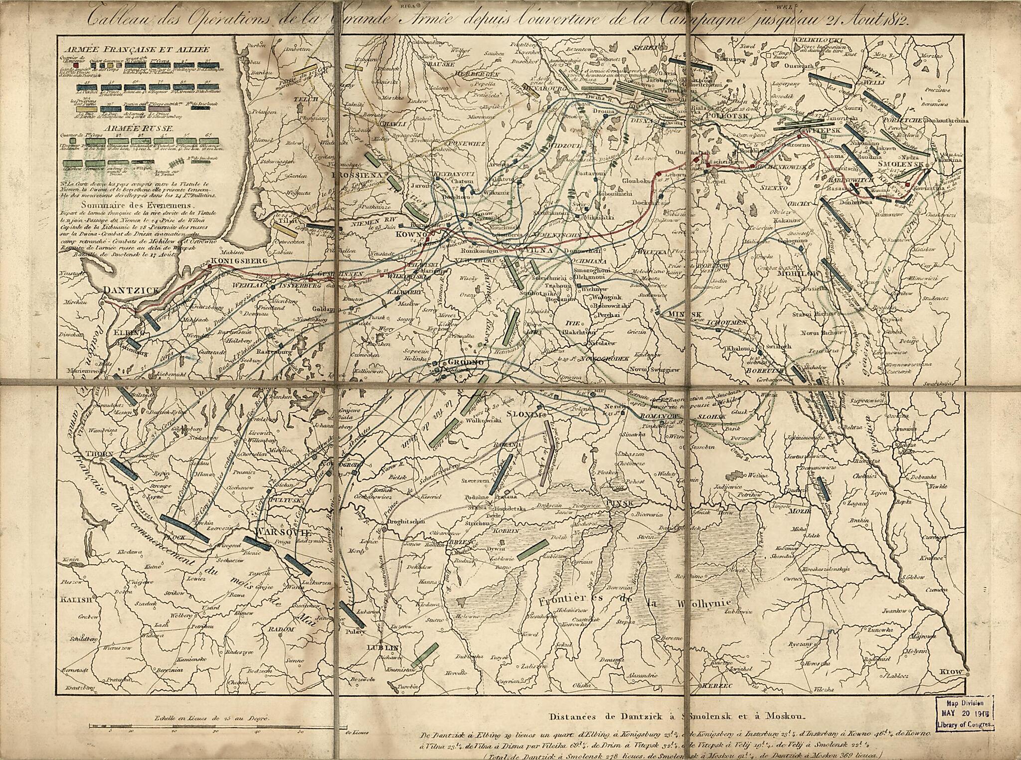
Old military map of Eastern Europe, Europe, Eastern, Poland, Russia (Federation), Russian Federation.- Shows the advance of the French Napoleonic forces eastward from Dantzick (Gdańsk, Poland) to Smolensk (Russia) by 21 August 1812.
- Indicates the French and Russian army troop positions and movements in what is now Poland, Lithuania, Belarus, and Russia.
- No statement of attribution or date of publication are present.
- Title from upper margin.
- No handwritten signature of Millard Fillmore is present (recto or verso).
- When affixed to the cloth backing the map sheet was sectioned to 6 panels to enable folding.
- Includes text, bar scale "Échelle en lieues de 25 au degré", and note "Distances de Dantzick à Smolensk et à Moskou".
- Handwritten (script) title slip affixed to cloth backing (verso): Map of the War of 1812 in Europe; number label affixed to cloth backing; 240.
Map Subjects
Campaigns
Europe Eastern
Military Maps
Napoleonic Wars
Poland
Russia (Federation)
Eastern Europe
Russian Federation
1812
- For the best legibility, order your map in the original size or larger. Most maps have intricate detail and small text that is best appreciated when the print size hasn't been reduced.
- Sizes labeled "Fits a Standard Frame" will drop right into any frame that you purchase in that size. The sizes that we offer are commonly available online and at most retail stores.
- Our standard sizes are recommendations based on the aspect ratio of the original map, but still may require some added "white space" in one dimension to fit.
- Non-standard sizes will require custom framing, and we suggest taking your print to the frame shop of your choice after you receive it for the best results.
- Custom sizes are available, simply contact us for a quote.
Below is an approximation of the scale of a few standard sizes, and how they might appear in your space.

