
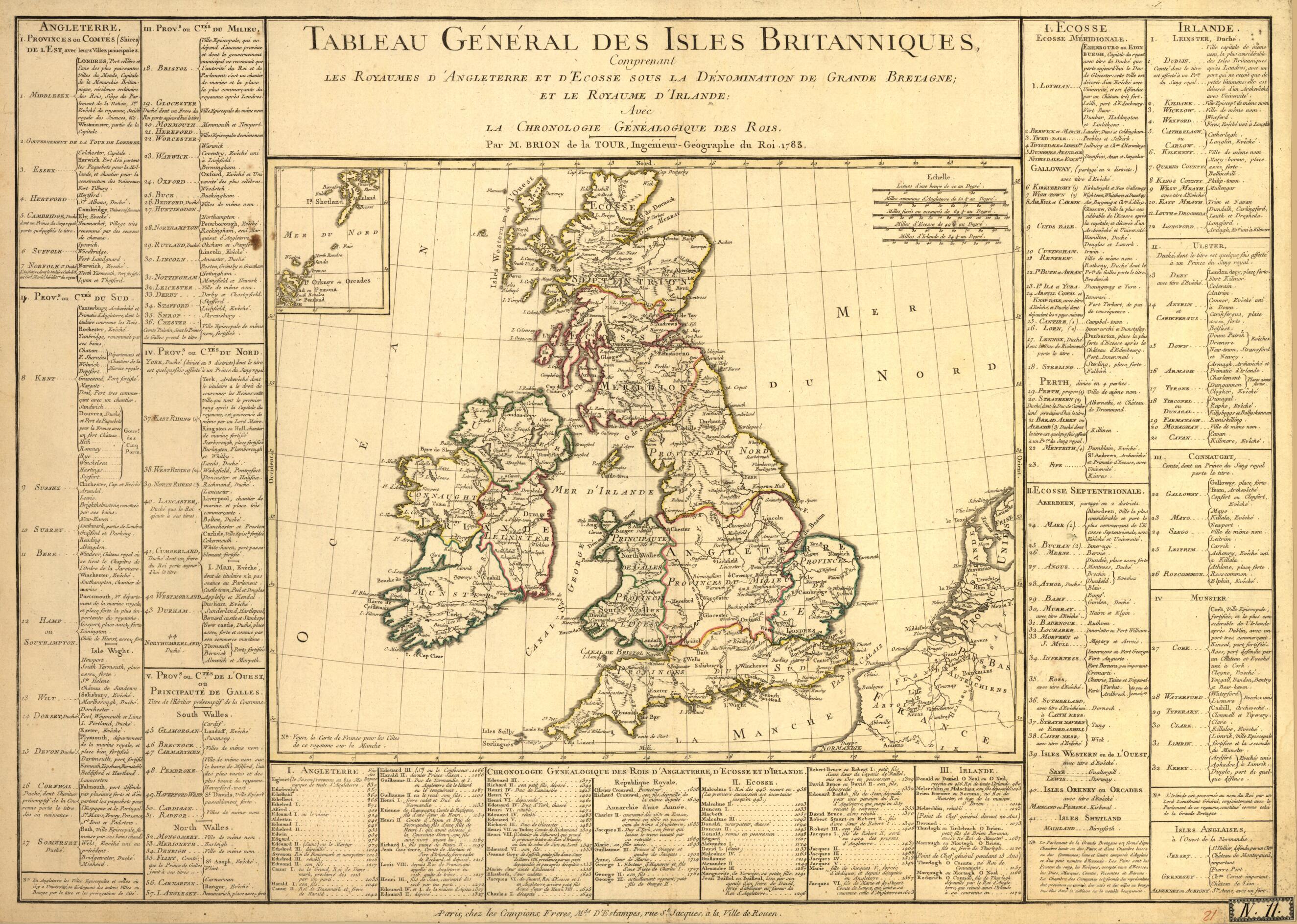
Tableau Général Des Isles Britanniques : Comprenant Les Royaumes D'A̓ngleterre Et D'Ecosse Sous La Dénomination De Grande Bretagne, Et Le Royaume D'I̓rlande, Avec La Chronologie Généalogique Des Rois 1783
- Regular price
-
$73.95 - Regular price
-
$68.95 - Sale price
-
$73.95
Buy one map, get any other map in our collection for 50% OFF! Add to cart to see discount.
Couldn't load pickup availability
About This Map
Discover the timeless beauty of our fine art quality printed reproduction of this antique map. Perfect for history enthusiasts, collectors, and interior decorators.
Restored with meticulous attention to detail by our team with over a decade of experience, this stunning reproduction captures the intricate artistry and historical significance of the original map.
Whether you're a collector or seeking a unique decor piece, this archival-quality map reproduction is a timeless addition to any space. Order now to bring history to life!
Old early map of British Isles.Created by Louis Brion De La Tour, Campion Frères in 1783.
- Relief shown pictorially.
- Includes tables for England, Scotland, and Ireland listing the counties or shires, their major cities and towns, a chronological genealogy of the kings of England, Scotland, and Ireland, and inset of the Shetland and Orkney islands.
- In red pencil in lower margin: 21; in ink on small label pasted in lower margin: IV. 11.; in ink on verso: Cah. 8. no. 11., No. Sn 21. 23; in pencil on verso: illegible number crossed out.
- For the best legibility, order your map in the original size or larger. Most maps have intricate detail and small text that is best appreciated when the print size hasn't been reduced.
- Sizes labeled "Fits a Standard Frame" will drop right into any frame that you purchase in that size. The sizes that we offer are commonly available online and at most retail stores.
- Our standard sizes are recommendations based on the aspect ratio of the original map, but still may require some added "white space" in one dimension to fit.
- Non-standard sizes will require custom framing, and we suggest taking your print to the frame shop of your choice after you receive it for the best results.
- Custom sizes are available, simply contact us for a quote.
Below is an approximation of the scale of a few standard sizes, and how they might appear in your space.

