
-Tenn. Profield sic June 1863 (-Tenn. Profiled June 1863)
- Regular price
-
$49.95 - Regular price
-
$34.95 - Sale price
-
$49.95
Shipping calculated at checkout.
Buy one map, get any other map in our collection for 50% OFF! Add to cart to see discount.
Couldn't load pickup availability
About This Map
Old map of Appalachian Mountains, Franklin Region, Lookout Mountain Region, Lookout Mountain Region (Appalachian Mountains), Tennessee, United States.
Created by G. H. Blakeslee in 1863.
Created by G. H. Blakeslee in 1863.
- Sketch map showing troop positions, roads, railroads, streams, and location of the "Cherry tree where was [sic] hung the rebel spies Col. Williams and Lieut. W.G. Peter--June 10, 1863".
- Relief shown by hachures.
- Pen-and-ink (brown/red/dark blue).
- Added in red ink below title: Position of troops at the battle here, added since close of the war--G.H.B.
- Mounted on paper backing.
- Watermark: Franklin Mills.
- This map has some imperfections: scattered water stains. We'll do our best to restore the image before printing.
- Includes ill.: Carter House, west of Columbia Pike -- Gin house, east of Columbia Pike -- Bridge over the Harpeth.
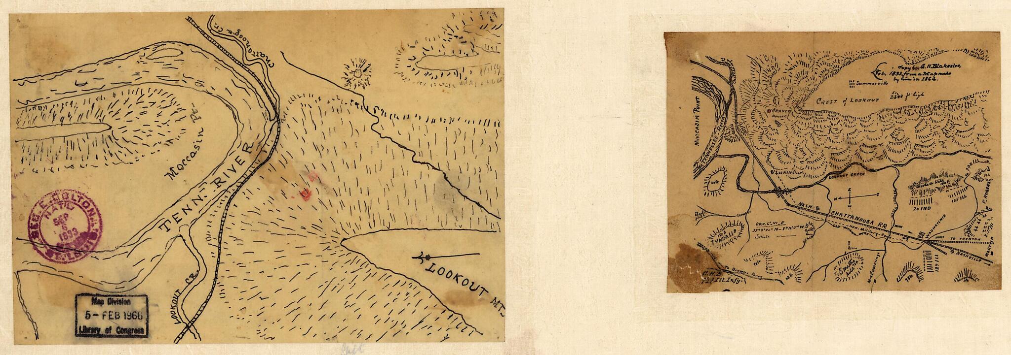
- Two maps pasted on verso on paper backing: [Unattributed ms. map of Lookout Mountain vicinity] -- [Printed map of Lookout Mountain vicinity] / copy by G.H. Blakeslee, Feb. 1893, from a map made by him in 1864.
- Civil War Map
- Gift; Mrs. Geo. W. Volk, Lexington, Neb.; Jan. 1966.
Map Subjects
Civil War
Franklin Region
Franklin Region (Tenn.)
Franklin Battle Of Franklin Tenn
History
Lookout Mountain Region (Appalachian Mountains)
Lookout Mountain Battle Of Tenn
Maps Manuscript
Tennessee
United States
Appalachian Mountains
Lookout Mountain Region
G. H. Blakeslee
1863
Map Sizing Information
- For the best legibility, order your map in the original size or larger. Most maps have intricate detail and small text that is best appreciated when the print size hasn't been reduced.
- Sizes labeled "Fits a Standard Frame" will drop right into any frame that you purchase in that size. The sizes that we offer are commonly available online and at most retail stores.
- Our standard sizes are recommendations based on the aspect ratio of the original map, but still may require some added "white space" in one dimension to fit.
- Non-standard sizes will require custom framing, and we suggest taking your print to the frame shop of your choice after you receive it for the best results.
- Custom sizes are available, simply contact us for a quote.
Below is an approximation of the scale of a few standard sizes, and how they might appear in your space.
