
Tenochtitlán, 1521 in 1550
- Regular price
-
$229.95 - Regular price
-
$224.95 - Sale price
-
$229.95
Buy one map, get any other map in our collection for 50% OFF! Add to cart to see discount.
Couldn't load pickup availability
About This Map
Discover the timeless beauty of our fine art quality printed reproduction of this antique map. Perfect for history enthusiasts, collectors, and interior decorators.
Restored with meticulous attention to detail by our team with over a decade of experience, this stunning reproduction captures the intricate artistry and historical significance of the original map.
Whether you're a collector or seeking a unique decor piece, this archival-quality map reproduction is a timeless addition to any space. Order now to bring history to life!
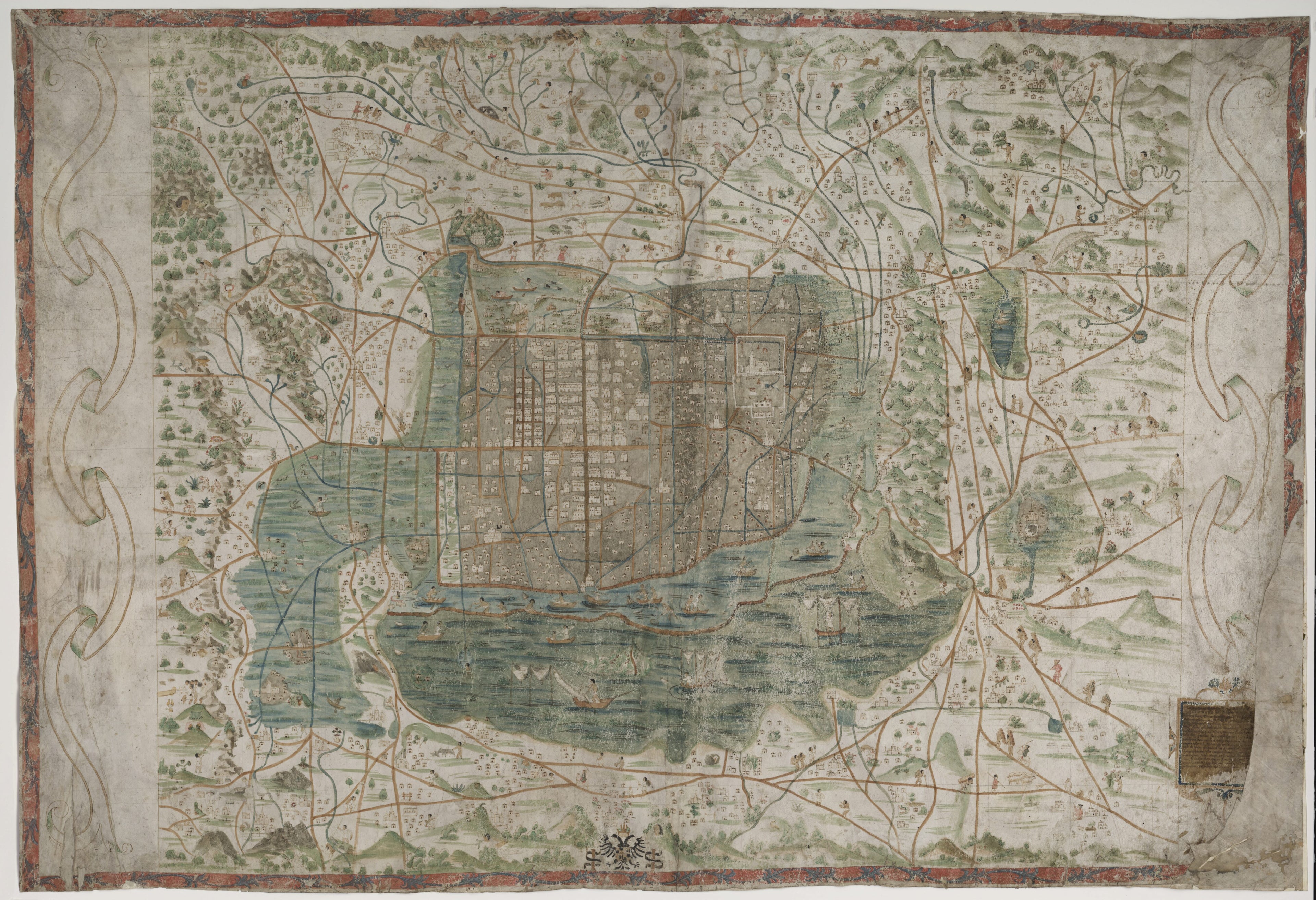
Old map of Distrito Federal, Mexico, Mexico City.hand corner, along with parts of the name Santa Cruz, which is why the royal cosmographer in Seville, Alfonso de Santa Cruz (1505--67), long was thought to have been the cartographer. Later research indicates that the map was painted by a person from Tenochtitlán/Mexico City, probably an Aztec with European schooling. It is known that Santa Cruz never visited Mexico, and the construction and content of the map suggest that its maker was very familiar with the place and its inhabitants. The symbols on the map (heads, animals, rings, stars, and so forth) represent place-names in Nahuatl, the language of the Aztecs. The map contains information about social and working life and animals and plants, thus providing both a geographical description and a rich picture of everyday life in 16th-century Mexico City. The frame consists of ornamental foliage painted in blue on a red background. Roads and canals are marked in brown and light blue. How the map came to Sweden is not known. One theory is that Swedish linguist and traveler Johan Gabriel Sparwenfeld purchased it during his stay in Spain in the late 17th century and that it later was donated to the Uppsala University Library.
- Title devised, in English, by Library staff.
- Original resource extent: 1 map, 75 x 144 centimeters, hand-painting on two joined pieces of parchment.
- Original resource at: Uppsala University Library.
- Content in Latin and Classical Nahuatl and Spanish.
- Description based on data extracted from World Digital Library, which may be extracted from partner institutions.
- For the best legibility, order your map in the original size or larger. Most maps have intricate detail and small text that is best appreciated when the print size hasn't been reduced.
- Sizes labeled "Fits a Standard Frame" will drop right into any frame that you purchase in that size. The sizes that we offer are commonly available online and at most retail stores.
- Our standard sizes are recommendations based on the aspect ratio of the original map, but still may require some added "white space" in one dimension to fit.
- Non-standard sizes will require custom framing, and we suggest taking your print to the frame shop of your choice after you receive it for the best results.
- Custom sizes are available, simply contact us for a quote.
Below is an approximation of the scale of a few standard sizes, and how they might appear in your space.
