
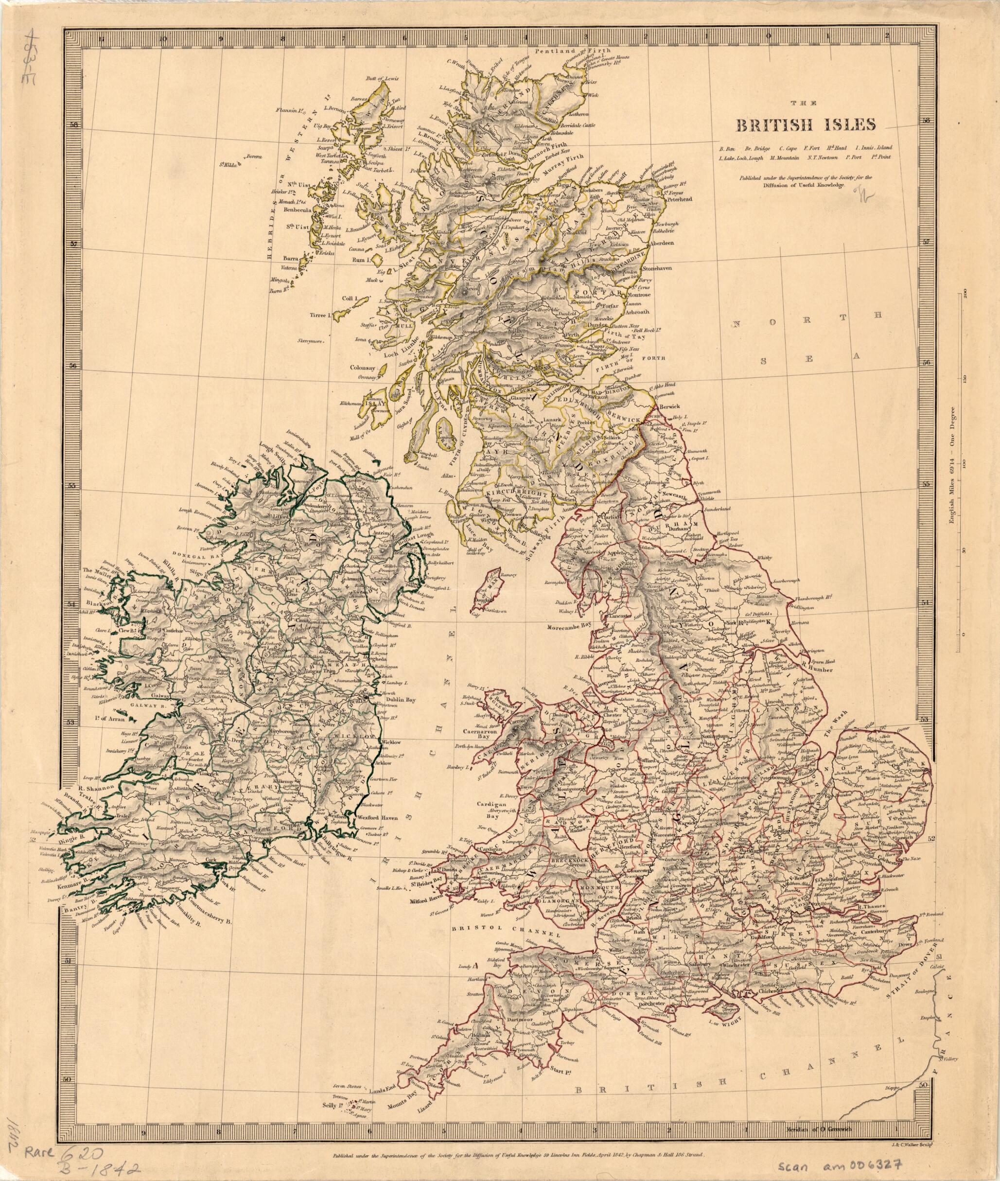
The British Isles 1842
- Regular price
-
$49.95 - Regular price
-
$34.95 - Sale price
-
$49.95
Buy one map, get any other map in our collection for 50% OFF! Add to cart to see discount.
Couldn't load pickup availability
About This Map
Discover the timeless beauty of our fine art quality printed reproduction of this antique map. Perfect for history enthusiasts, collectors, and interior decorators.
Restored with meticulous attention to detail by our team with over a decade of experience, this stunning reproduction captures the intricate artistry and historical significance of the original map.
Whether you're a collector or seeking a unique decor piece, this archival-quality map reproduction is a timeless addition to any space. Order now to bring history to life!
Old map of England, Ireland, Northern Ireland, Scotland, United Kingdom of Great Britain and Northern Ireland, Wales.19th century. It was published by Chapman and Hall, a London bookselling and publishing business established in 1830 by William Hall (1800--1847) and Edward Chapman (1804--80), best known for issuing works by Charles Dickens and other important Victorian novelists and poets. The map shows counties, cities and towns, rivers, bridges, forts, and other natural and man-made features. Relief is shown by hachures. Hand-colored lines highlight the boundaries between counties, with different colors used for the counties of England and Wales, Scotland, and Ireland. The borders between England and Scotland and England and Wales are marked with a dashed line. A small part of the coast of France is visible in the lower right. No distance scale is given on the map. In the 1830s and 1840s, the Society for the Diffusion of Useful Knowledge produced numerous publications, including a Library of Useful Knowledge, the volumes of which sold for sixpence, and a two-volume series of maps that were known for their high quality. More than 200 maps, also sold separately, were made, and more than 3 million copies were printed.
Created by J. & C. Walker, Society for the Diffusion of Useful Knowledge (Great Britain) in 1842.
- Title devised, in English, by Library staff.
- "Scale approximately 1:2,700,000"--Note extracted from World Digital Library.
- Original resource extent: 1 map : hand colored ; 38 x 22 centimeters.
- Original resource at: University of Wisconsin-Milwaukee Libraries.
- Content in English.
- Description based on data extracted from World Digital Library, which may be extracted from partner institutions.
- For the best legibility, order your map in the original size or larger. Most maps have intricate detail and small text that is best appreciated when the print size hasn't been reduced.
- Sizes labeled "Fits a Standard Frame" will drop right into any frame that you purchase in that size. The sizes that we offer are commonly available online and at most retail stores.
- Our standard sizes are recommendations based on the aspect ratio of the original map, but still may require some added "white space" in one dimension to fit.
- Non-standard sizes will require custom framing, and we suggest taking your print to the frame shop of your choice after you receive it for the best results.
- Custom sizes are available, simply contact us for a quote.
Below is an approximation of the scale of a few standard sizes, and how they might appear in your space.

