
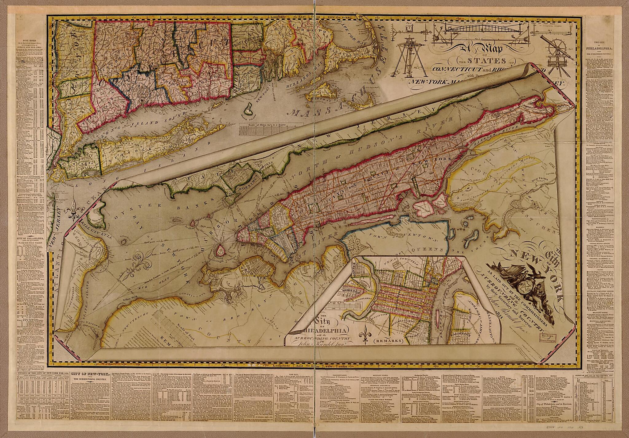
The City of New York As Laid Out by the Commissioners With the Surrounding Country 1821
- Regular price
-
$112.95 - Regular price
-
$107.95 - Sale price
-
$112.95
Buy one map, get any other map in our collection for 50% OFF! Add to cart to see discount.
Couldn't load pickup availability
About This Map
Discover the timeless beauty of our fine art quality printed reproduction of this antique map. Perfect for history enthusiasts, collectors, and interior decorators.
Restored with meticulous attention to detail by our team with over a decade of experience, this stunning reproduction captures the intricate artistry and historical significance of the original map.
Whether you're a collector or seeking a unique decor piece, this archival-quality map reproduction is a timeless addition to any space. Order now to bring history to life!
Old map of Manhattan, Manhattan (New York), New York, New York (State), Northeast Atlantic States, Pennsylvania, Philadelphia, United States.Created by John Randel in 1821.
- Street planning map. Covers all of Manhattan Island (New York, N.Y.) and substantial parts of adjacent counties in New York and New Jersey. Shows existing and proposed streets; also buildings and other structures, streams and other wetlands, political boundaries.
- Shows relief by hachures.
- Includes illustrations of surveying equipment used by the author.
- Includes extensive text in left, right and lower margins outside neat line.
- Includes 2 ancillary maps: Map of the States of Connecticut and Rh[ode Island] with p[arts of] New York, ...; The City of Philadelphia with the surrounding country by John Randel Junr.
- Mounted on cloth and taped to brown binding.
- "Longitude East from London."
Map Subjects
Manhattan (New York)
Manhattan (New York N.Y.)
New York (State)
Northeast Atlantic States
Pennsylvania
Philadelphia
Philadelphia (Pa.)
United States
Manhattan
New York
John Randel
1821
- For the best legibility, order your map in the original size or larger. Most maps have intricate detail and small text that is best appreciated when the print size hasn't been reduced.
- Sizes labeled "Fits a Standard Frame" will drop right into any frame that you purchase in that size. The sizes that we offer are commonly available online and at most retail stores.
- Our standard sizes are recommendations based on the aspect ratio of the original map, but still may require some added "white space" in one dimension to fit.
- Non-standard sizes will require custom framing, and we suggest taking your print to the frame shop of your choice after you receive it for the best results.
- Custom sizes are available, simply contact us for a quote.
Below is an approximation of the scale of a few standard sizes, and how they might appear in your space.
