
The Daily Telegraph War Map of Egypt and the Near East (Number 6) 1918
- Regular price
-
$86.95 - Regular price
-
$81.95 - Sale price
-
$86.95
Buy one map, get any other map in our collection for 50% OFF! Add to cart to see discount.
Couldn't load pickup availability
About This Map
Discover the timeless beauty of our fine art quality printed reproduction of this antique map. Perfect for history enthusiasts, collectors, and interior decorators.
Restored with meticulous attention to detail by our team with over a decade of experience, this stunning reproduction captures the intricate artistry and historical significance of the original map.
Whether you're a collector or seeking a unique decor piece, this archival-quality map reproduction is a timeless addition to any space. Order now to bring history to life!
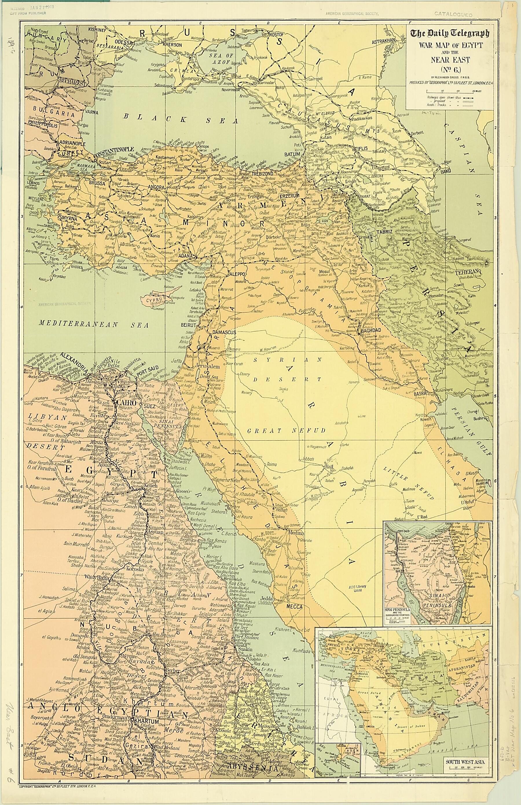
Old map of Armenia, Azerbaijan, Cyprus, Egypt, Eritrea, Georgia, Iran, Islamic Republic of, Iraq, Israel, Jordan, Kuwait, Lebanon, Russian Federation, Saudi Arabia, Sudan, Syrian Arab Republic, Turkey.day states of the Persian Gulf states are labeled "East India Co (Brit)." Railroad routes, both actual and proposed, roads, and tracks are marked. Inset maps depict the Sinai Peninsula and surrounding countries and the wider Southwest Asia region. The map probably was distributed with The Daily Telegraph newspaper. It was published by Geographia, a British firm that issued numerous war maps between 1914 and 1918, described in advertising as "the most extensive series of popular-priced war maps issued." Maps were sold as single sheets, as this one, or in folding pocket editions. Geographia was founded in 1911 by cartographer Alexander Gross. He was by all accounts a colorful personality, "a truculent Hungarian immigrant." His daughter, the successful commercial mapmaker Phyllis Pearsall, called him "an impossible father (loved in retrospect)." After the war, Geographia went into bankruptcy and Gross immigrated to New York, where he reestablished his business. In the 1930s, Pearsall continued the map company in London as Geographers' A-Z Map Company.
Created by Alexander Gross, The Daily Telegraph in 1918.
- Title devised, in English, by Library staff.
- "Scale about 1:4,500,000"--Note extracted from World Digital Library.
- Original resource extent: 1 map : color ; 85 x 54 centimeters, folded to 19 x 12 centimeters.
- Original resource at: University of Wisconsin-Milwaukee Libraries.
- Content in English.
- Description based on data extracted from World Digital Library, which may be extracted from partner institutions.
Map Subjects
Arabian Gulf
Arabian Peninsula
Armenia
Azerbaijan
Cyprus
Egypt
Eritrea
Georgia
Iran Islamic Republic Of
Iraq
Israel
Jordan
Kuwait
Lebanon
Persian Gulf
Red Sea
Russian Federation
Saudi Arabia
Sudan
Syrian Arab Republic
Turkey
World War
Alexander Gross
The Daily Telegraph
1918
- For the best legibility, order your map in the original size or larger. Most maps have intricate detail and small text that is best appreciated when the print size hasn't been reduced.
- Sizes labeled "Fits a Standard Frame" will drop right into any frame that you purchase in that size. The sizes that we offer are commonly available online and at most retail stores.
- Our standard sizes are recommendations based on the aspect ratio of the original map, but still may require some added "white space" in one dimension to fit.
- Non-standard sizes will require custom framing, and we suggest taking your print to the frame shop of your choice after you receive it for the best results.
- Custom sizes are available, simply contact us for a quote.
Below is an approximation of the scale of a few standard sizes, and how they might appear in your space.

