
The Description of the Coast of Guinea, Manicongo, and Angola, and So Proceeding Forwards Beyond the Cape of Good Hope, With All the Harbors, Islands, Cliffs, Sandbars, and Shallows. (Typus Orarum Maritimarum Guineae, Manicongo, & Angôlae Ultra Promo...
- Regular price
-
$69.95 - Regular price
-
$64.95 - Sale price
-
$69.95
Buy one map, get any other map in our collection for 50% OFF! Add to cart to see discount.
Couldn't load pickup availability
About This Map
Discover the timeless beauty of our fine art quality printed reproduction of this antique map. Perfect for history enthusiasts, collectors, and interior decorators.
Restored with meticulous attention to detail by our team with over a decade of experience, this stunning reproduction captures the intricate artistry and historical significance of the original map.
Whether you're a collector or seeking a unique decor piece, this archival-quality map reproduction is a timeless addition to any space. Order now to bring history to life!
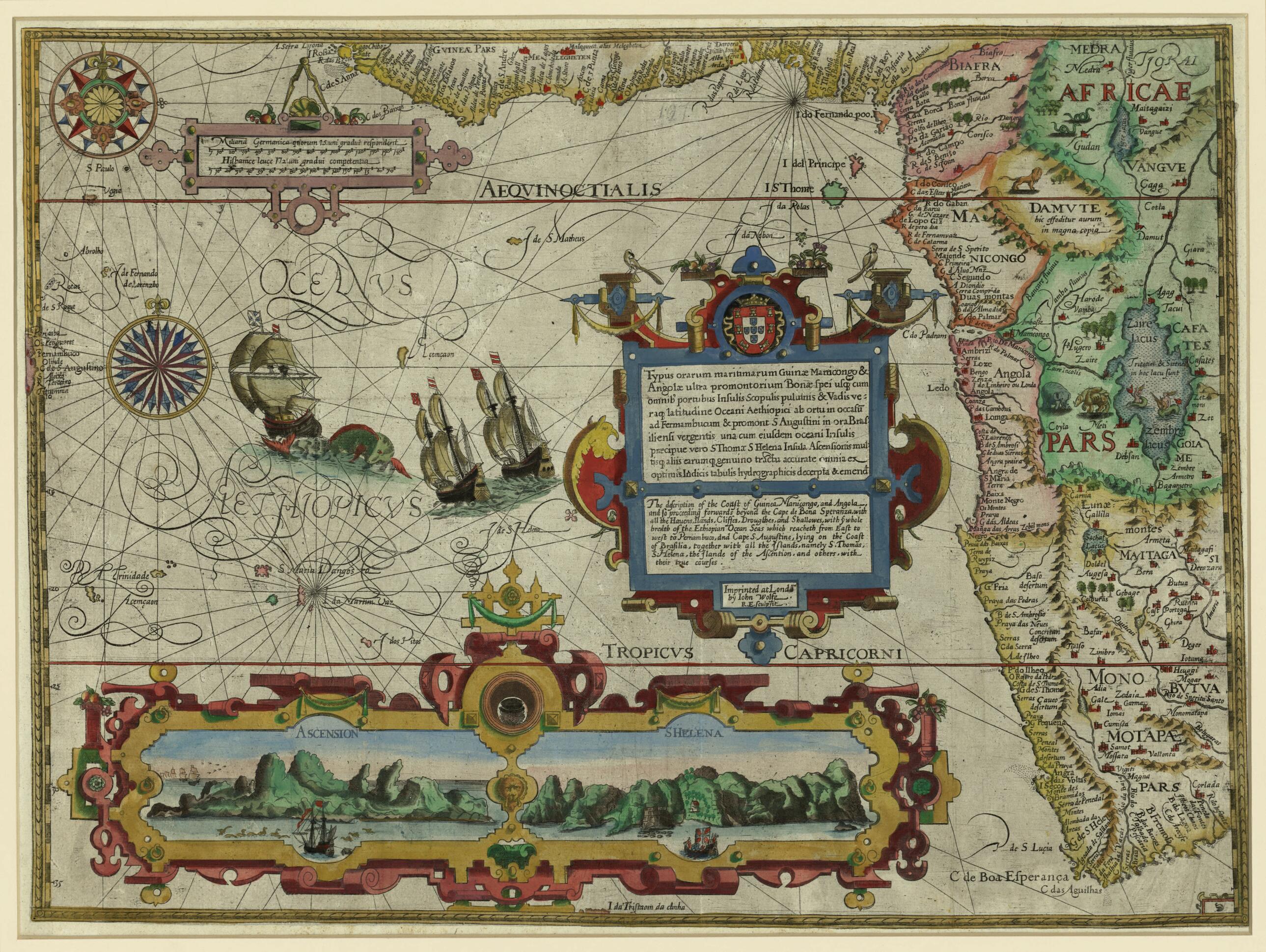
Old map of Angola, Benin, Cameroon, Congo, Côte d'Ivoire, Democratic Republic of the Congo, Equatorial Guinea, Gabon, Ghana, Namibia, Nigeria, South Africa.1611) spent five years in the "Portuguese State of India" and its capital at Goa in the 1580s. There he learned the safe navigation routes to Asia, which the Portuguese treated as closely guarded national secrets in order to protect their monopoly on trade with the Spice Islands. The Amsterdam bookseller, printer, and publisher Cornelis Claesz recognized the potential in Van Linschoten's knowledge of the East, and helped him to produce the three books of the Itinerario. Claesz supplemented the narrative with maps by well-known cartographers, such as the map shown here, superbly engraved in the Flemish style by Florent van Langren. The scale is in German miles and Spanish leagues. It includes coastal views of the South Atlantic islands of Ascension and Saint Helena within a strapwork cartouche at the bottom of the map and two compass roses. The title cartouche is decorated with birds, fruit, and scroll-work. The sea is decorated with ships and a sea monster, the land with animals and mythical creatures. The map shows the western coast of Africa from the Gulf of Guinea to just beyond the Cape of Good Hope, with excellent detail along the coastline.
Created by Arnold Florent Van Langren, Jan Huygen Van Linschoten in 1596.
- Title devised, in English, by Library staff.
- "Scale about 1:13,000,000"--Note extracted from World Digital Library.
- Original resource extent: 1 map : hand colored ; 39 x 53 centimeters.
- Original resource at: Qatar National Library.
- Content in English and Latin.
- Description based on data extracted from World Digital Library, which may be extracted from partner institutions.
- For the best legibility, order your map in the original size or larger. Most maps have intricate detail and small text that is best appreciated when the print size hasn't been reduced.
- Sizes labeled "Fits a Standard Frame" will drop right into any frame that you purchase in that size. The sizes that we offer are commonly available online and at most retail stores.
- Our standard sizes are recommendations based on the aspect ratio of the original map, but still may require some added "white space" in one dimension to fit.
- Non-standard sizes will require custom framing, and we suggest taking your print to the frame shop of your choice after you receive it for the best results.
- Custom sizes are available, simply contact us for a quote.
Below is an approximation of the scale of a few standard sizes, and how they might appear in your space.

