
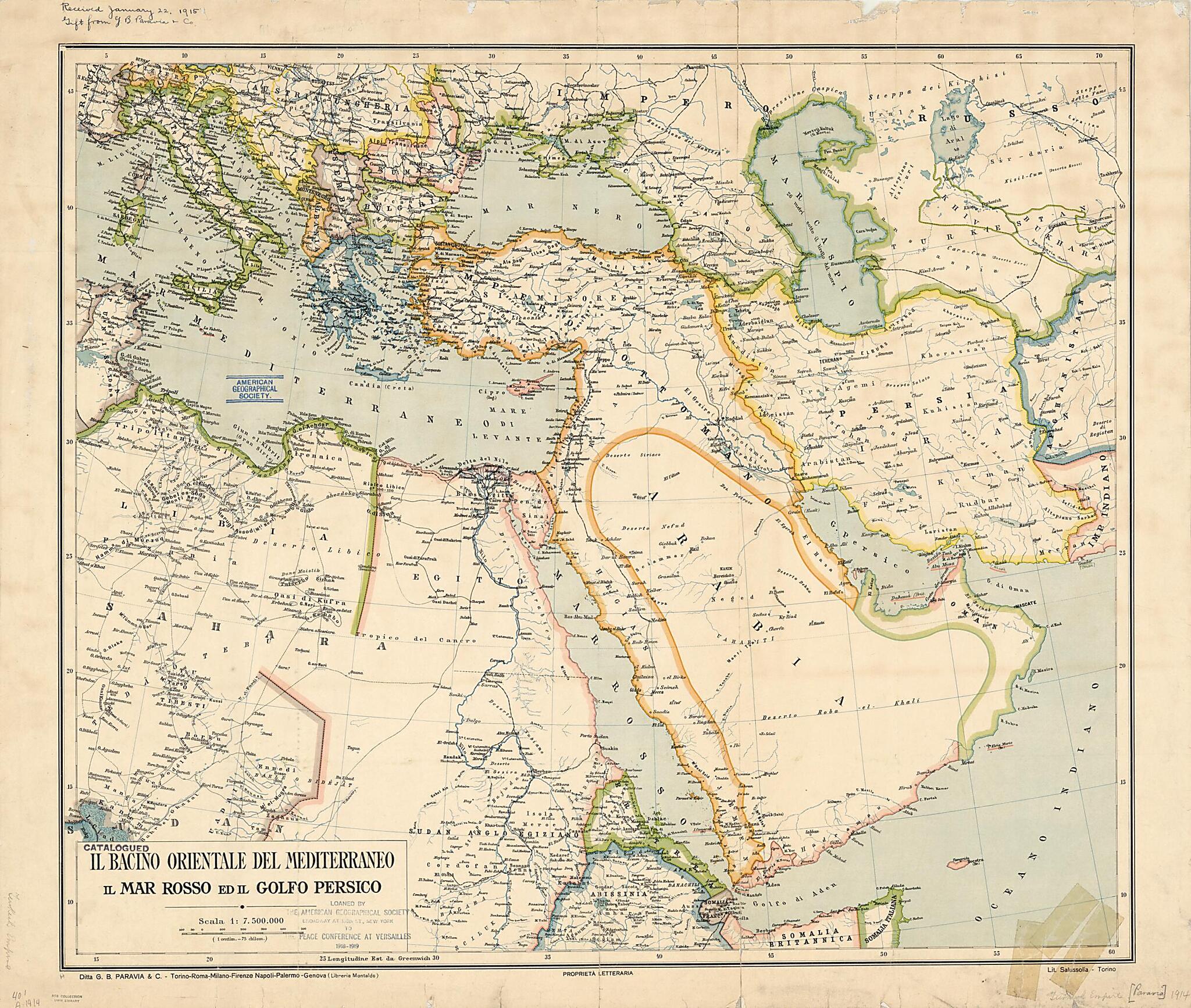
The Eastern Basin of the Mediterranean, the Red Sea, and the Persian Gulf. (Il Bacino Orientale Del Mediterraneo Il Mar Rosso Ed Il Golfo Persico) 1890
- Regular price
-
$84.95 - Regular price
-
$79.95 - Sale price
-
$84.95
Buy one map, get any other map in our collection for 50% OFF! Add to cart to see discount.
Couldn't load pickup availability
About This Map
Discover the timeless beauty of our fine art quality printed reproduction of this antique map. Perfect for history enthusiasts, collectors, and interior decorators.
Restored with meticulous attention to detail by our team with over a decade of experience, this stunning reproduction captures the intricate artistry and historical significance of the original map.
Whether you're a collector or seeking a unique decor piece, this archival-quality map reproduction is a timeless addition to any space. Order now to bring history to life!
Old map of Albania, Armenia, Azerbaijan, Bahrain, Bosnia and Herzegovina, Bulgaria, Croatia, Cyprus, Egypt, Eritrea, Former Yugoslav Republic of Macedonia, Georgia, Greece, Iran, Islamic Republic of, Iraq, Israel, Italy, Jordan, Kuwait, Oman, Romania, Serbia, Slovenia, Turkey, United Arab Emirates, Yemen.Egiziano (Anglo-Egyptian Sudan), where Sudan is shown as an extension of Egypt proper, thus giving another clue to the date, as joint rule over Sudan began in 1899. The area at bottom left that is labeled Sudan corresponds to parts of present-day Sudan, South Sudan, Central African Republic, and Chad. The map covers the region from Tunisia on the west to the borders of Afghanistan on the east, and Switzerland on the north to Sudan and parts of Somalia on the south. Except for river courses and large lakes, few internal geologic or hydrographic features are shown. The scale is given in kilometers. Place-names are in Italian. The firm of G.B. Paravia specialized in educational publishing. The map was printed in color at the Salussolia press of Turin, one of several lithographers in the city, which printed books, banknotes, and advertising posters as well as maps. A note on the map indicates that it was loaned by the American Geographical Society to the Paris Peace Conference of 1918--19, convened to draw up peace treaties after World War I.
Created by Paravia (Firm), Salussolia in 1890.
- Title devised, in English, by Library staff.
- "Scale 1:7,500,000"--Note extracted from World Digital Library.
- Original resource extent: 1 map : color ; 60 x 71 centimeters.
- Original resource at: University of Wisconsin-Milwaukee Libraries.
- Content in Italian.
- Description based on data extracted from World Digital Library, which may be extracted from partner institutions.
Map Subjects
1890 To 1900
Albania
Arabian Gulf
Arabian Peninsula
Armenia
Azerbaijan
Bahrain
Bosnia And Herzegovina
Bulgaria
Croatia
Cyprus
Egypt
Eritrea
Former Yugoslav Republic Of Macedonia
Georgia
Greece
Iran Islamic Republic Of
Iraq
Israel
Italy
Jordan
Kuwait
Oman
Persian Gulf
Red Sea
Romania
Serbia
Slovenia
Treaty Of Versailles (1919)
Turkey
United Arab Emirates
Yemen
Paravia (Firm)
Salussolia
1890
- For the best legibility, order your map in the original size or larger. Most maps have intricate detail and small text that is best appreciated when the print size hasn't been reduced.
- Sizes labeled "Fits a Standard Frame" will drop right into any frame that you purchase in that size. The sizes that we offer are commonly available online and at most retail stores.
- Our standard sizes are recommendations based on the aspect ratio of the original map, but still may require some added "white space" in one dimension to fit.
- Non-standard sizes will require custom framing, and we suggest taking your print to the frame shop of your choice after you receive it for the best results.
- Custom sizes are available, simply contact us for a quote.
Below is an approximation of the scale of a few standard sizes, and how they might appear in your space.

