
The Game of France. (Le Jeu De France) 1659
- Regular price
-
$49.95 - Regular price
-
$34.95 - Sale price
-
$49.95
Buy one map, get any other map in our collection for 50% OFF! Add to cart to see discount.
Couldn't load pickup availability
About This Map
Discover the timeless beauty of our fine art quality printed reproduction of this antique map. Perfect for history enthusiasts, collectors, and interior decorators.
Restored with meticulous attention to detail by our team with over a decade of experience, this stunning reproduction captures the intricate artistry and historical significance of the original map.
Whether you're a collector or seeking a unique decor piece, this archival-quality map reproduction is a timeless addition to any space. Order now to bring history to life!
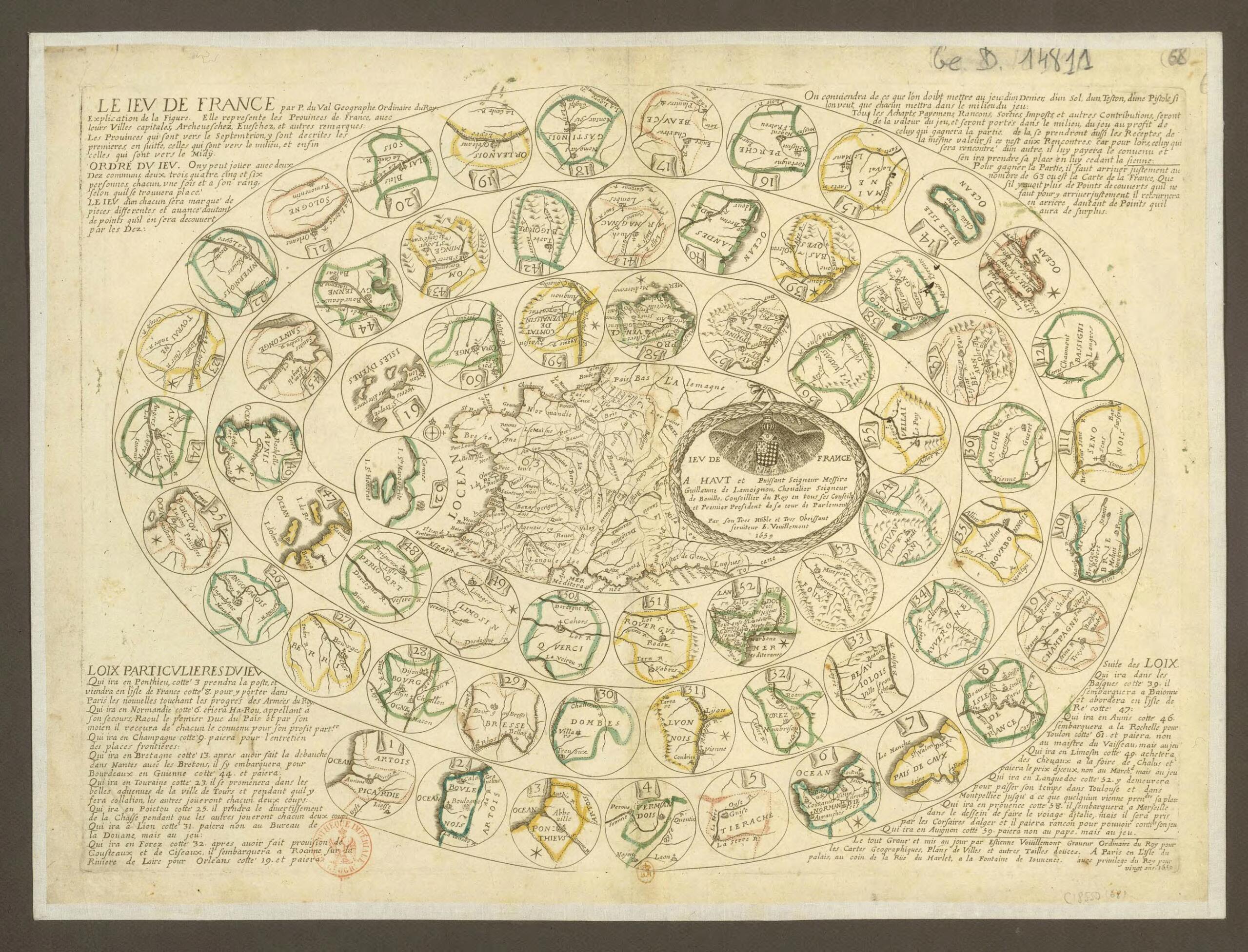
Old map of France, Paris, De-France.83) was a nephew of the great French geographer Nicolas Sanson (1600-67) who rose to become "geographer to the king" in his own right. In the 1660s and 1670s he published a large number of atlases and geographic works. Duval was the first in France to conceive of geographical games that aimed to inform and instruct while providing entertainment. Jeu de France (The game of France) is a chutes-and-ladders game made up of 63 squares, each representing a province, except for the last, which contains a map of the entire kingdom. The game offers insight into the clichés and stereotypes that Parisians applied to the French provinces. Brittany is noted for its debauchery, Tours for its lovely avenues, Forez for its knives and scissors, and Ponthieu as a theater of operations for the king's army (a reference to the recent Franco-Spanish war).
Created by Pierre Duval in 1659.
- Title devised, in English, by Library staff.
- Original resource extent: Print, copper engraving, color enhancements, 38 x 53 centimeters.
- Original resource at: National Library of France.
- Content in French.
- Description based on data extracted from World Digital Library, which may be extracted from partner institutions.
- For the best legibility, order your map in the original size or larger. Most maps have intricate detail and small text that is best appreciated when the print size hasn't been reduced.
- Sizes labeled "Fits a Standard Frame" will drop right into any frame that you purchase in that size. The sizes that we offer are commonly available online and at most retail stores.
- Our standard sizes are recommendations based on the aspect ratio of the original map, but still may require some added "white space" in one dimension to fit.
- Non-standard sizes will require custom framing, and we suggest taking your print to the frame shop of your choice after you receive it for the best results.
- Custom sizes are available, simply contact us for a quote.
Below is an approximation of the scale of a few standard sizes, and how they might appear in your space.

