
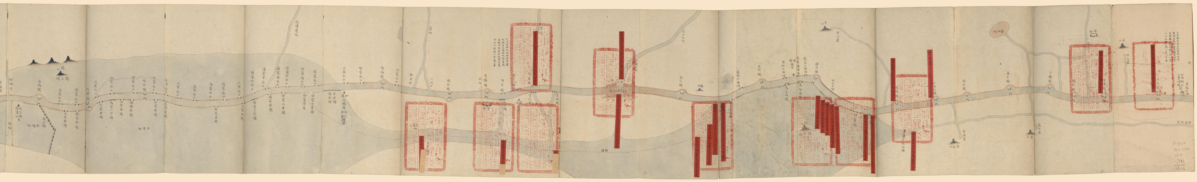
運加捕上下泉六廳光绪二年分做過嵗搶二修另案等工用過銀兩及河道起止里數圖, the Grand Canal Embankment Rapair Map for Yunjiabu in 1877
- Regular price
-
$204.95 - Regular price
-
$199.95 - Sale price
-
$204.95
Shipping calculated at checkout.
Buy one map, get any other map in our collection for 50% OFF! Add to cart to see discount.
Couldn't load pickup availability
About This Map
Old manuscript map of China, Grand Canal.
Created by Arthur W. (Arthur William) Hummel in 1877.
Created by Arthur W. (Arthur William) Hummel in 1877.
- Scale not given.
- Cover title.
- Manuscript; watercolor and ink.
- Labels pasted on to show distance and completed repairs on the canal.
- Relief shown pictorially.
- Shows the repaired water control system on the Grand Canal in Shangdong Province.
- Hummel gift 1962, no. 13b.
- Includes notes.
- Filed in the same box with Hummel gift 1962, no. 13a, G7822.G7N22 1876 .Y8 Vault Shelf.
Map Sizing Information
- For the best legibility, order your map in the original size or larger. Most maps have intricate detail and small text that is best appreciated when the print size hasn't been reduced.
- Sizes labeled "Fits a Standard Frame" will drop right into any frame that you purchase in that size. The sizes that we offer are commonly available online and at most retail stores.
- Our standard sizes are recommendations based on the aspect ratio of the original map, but still may require some added "white space" in one dimension to fit.
- Non-standard sizes will require custom framing, and we suggest taking your print to the frame shop of your choice after you receive it for the best results.
- Custom sizes are available, simply contact us for a quote.
Below is an approximation of the scale of a few standard sizes, and how they might appear in your space.
