
The Graphic Statistical Maps of Ireland 1886
- Regular price
-
$62.95 - Regular price
-
$44.95 - Sale price
-
$62.95
Buy one map, get any other map in our collection for 50% OFF! Add to cart to see discount.
Couldn't load pickup availability
About This Map
Discover the timeless beauty of our fine art quality printed reproduction of this antique map. Perfect for history enthusiasts, collectors, and interior decorators.
Restored with meticulous attention to detail by our team with over a decade of experience, this stunning reproduction captures the intricate artistry and historical significance of the original map.
Whether you're a collector or seeking a unique decor piece, this archival-quality map reproduction is a timeless addition to any space. Order now to bring history to life!
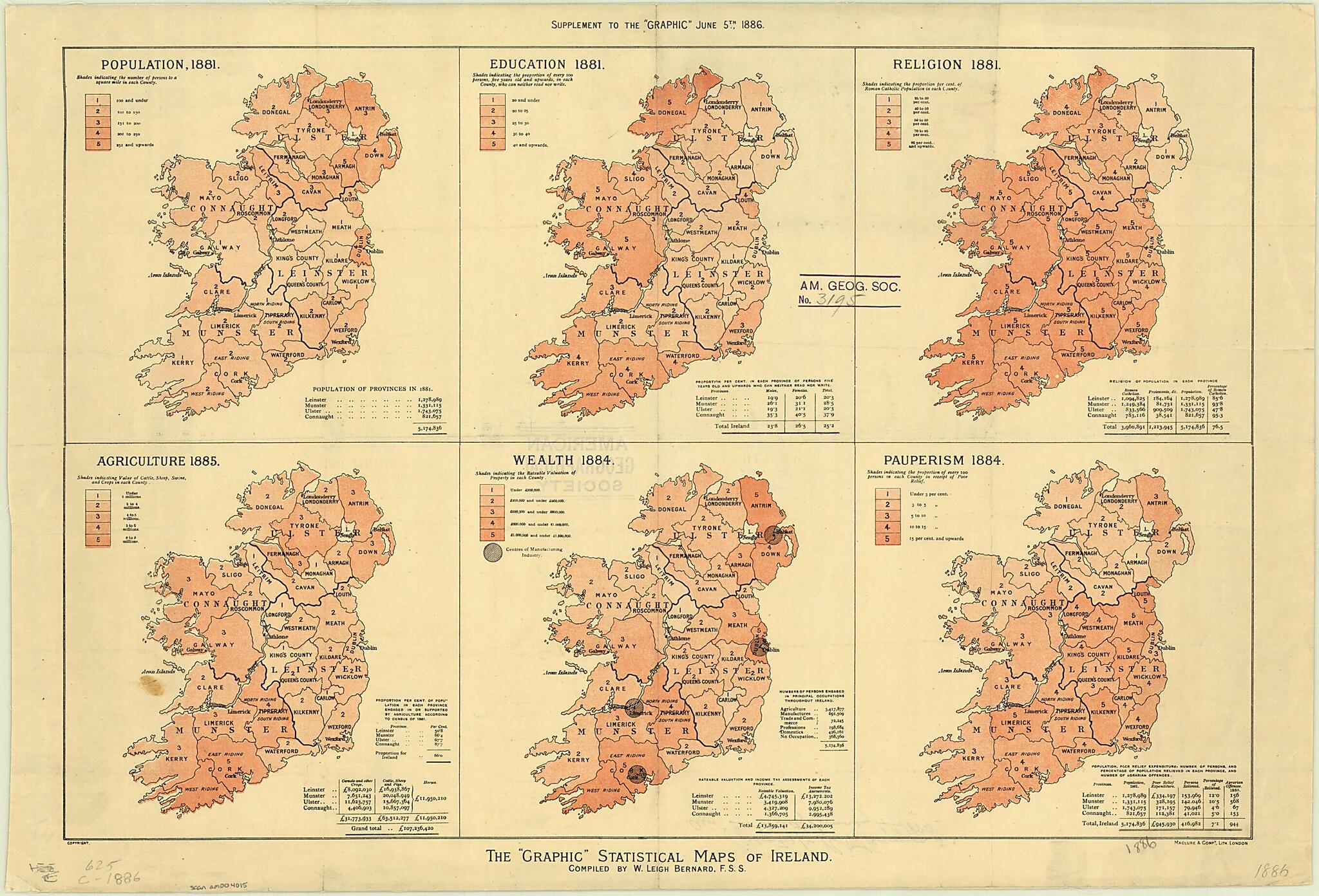
Old map of Ireland, Northern Ireland, United Kingdom of Great Britain and Northern Ireland.30 percent); the high level of "pauperism" (measured as the share of the population receiving some form of relief) in certain southern counties, notably Limerick and Kildare; and the national illiteracy rate of about 25 percent, with a particular concentration of 37.9 percent (more than 40 percent among females) in the province of Connaught. The maps originally appeared as a supplement to The Graphic, a popular British weekly illustrated newspaper published in London.
Created by William Leigh Bernard in 1886.
- Title devised, in English, by Library staff.
- Original resource extent: 6 maps on 1 sheet : color ; 43 x 62 centimeters.
- Original resource at: University of Wisconsin-Milwaukee Libraries.
- Content in English.
- Description based on data extracted from World Digital Library, which may be extracted from partner institutions.
Map Subjects
1881 To 1884
Ireland
Northern Ireland
Population
Statistics
United Kingdom Of Great Britain And Northern Ireland
William Leigh Bernard
1886
- For the best legibility, order your map in the original size or larger. Most maps have intricate detail and small text that is best appreciated when the print size hasn't been reduced.
- Sizes labeled "Fits a Standard Frame" will drop right into any frame that you purchase in that size. The sizes that we offer are commonly available online and at most retail stores.
- Our standard sizes are recommendations based on the aspect ratio of the original map, but still may require some added "white space" in one dimension to fit.
- Non-standard sizes will require custom framing, and we suggest taking your print to the frame shop of your choice after you receive it for the best results.
- Custom sizes are available, simply contact us for a quote.
Below is an approximation of the scale of a few standard sizes, and how they might appear in your space.
