
The Man of Commerce in 1889
- Regular price
-
$188.95 - Regular price
-
$183.95 - Sale price
-
$188.95
Buy one map, get any other map in our collection for 50% OFF! Add to cart to see discount.
Couldn't load pickup availability
About This Map
Discover the timeless beauty of our fine art quality printed reproduction of this antique map. Perfect for history enthusiasts, collectors, and interior decorators.
Restored with meticulous attention to detail by our team with over a decade of experience, this stunning reproduction captures the intricate artistry and historical significance of the original map.
Whether you're a collector or seeking a unique decor piece, this archival-quality map reproduction is a timeless addition to any space. Order now to bring history to life!
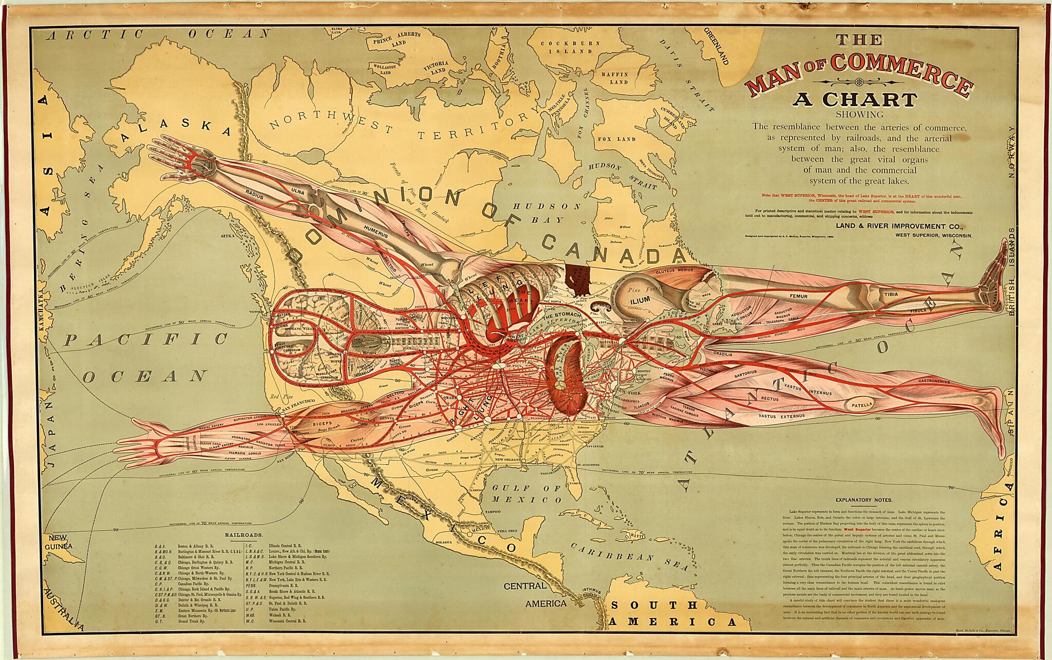
Old map of United States of America."The Man of Commerce" is a detailed map that conflates human anatomy with the American transportation system. Published in 1889 by the Land & River Improvement Company of Superior, Wisconsin, the map promotes Superior as a transportation hub and shows the routes of 29 railroads across the United States. The outline map of North America is superimposed by a cutaway diagram of the human body. The map's metaphor makes West Superior "the center of cardiac or heart circulation." The railways become major arteries. New York is "the umbilicus through which this man of commerce was developed." The explanatory notes conclude: "It is an interesting fact that in no other portion of the known world can any such analogy be found between the natural and artificial channels of commerce and circulatory and digestive apparatus of man." Use of the human body as a cartographic metaphor dates back at least to the 16th century, to the anthropomorphic map of Europe as a queen in Sebastian Münster's Cosmography (1570). This map may be the earliest application of this metaphor to North America. The cartographer was A.F. McKay, who in 1889 briefly served as the editor of the Superior Sentinel newspaper. The map was engraved by Rand McNally. The American Geographical Society Library acquired the map in 2009, aided in part by the Map Society of Wisconsin. The only other known copy of this map is in a private collection.
Created by A. F. (Augustus F.) McKay, Rand McNally and Company in 1889.
- Title devised, in English, by Library staff.
- "Relief shown by hachures. Includes text and guide to railroad abbreviations."--Note extracted from World Digital Library.
- Original resource extent: 1 map : color ; 79 x 127 centimeters.
- Original resource at: University of Wisconsin-Milwaukee Libraries.
- Content in English.
- Description based on data extracted from World Digital Library, which may be extracted from partner institutions.
Map Subjects
Commerce
Human Anatomy
Railroads
United States Of America
A. F. (Augustus F.) McKay
Rand McNally And Company
1889
- For the best legibility, order your map in the original size or larger. Most maps have intricate detail and small text that is best appreciated when the print size hasn't been reduced.
- Sizes labeled "Fits a Standard Frame" will drop right into any frame that you purchase in that size. The sizes that we offer are commonly available online and at most retail stores.
- Our standard sizes are recommendations based on the aspect ratio of the original map, but still may require some added "white space" in one dimension to fit.
- Non-standard sizes will require custom framing, and we suggest taking your print to the frame shop of your choice after you receive it for the best results.
- Custom sizes are available, simply contact us for a quote.
Below is an approximation of the scale of a few standard sizes, and how they might appear in your space.
