
The New Naval and Military Map of the United States 1862
- Regular price
-
$197.95 - Regular price
-
$192.95 - Sale price
-
$197.95
Buy one map, get any other map in our collection for 50% OFF! Add to cart to see discount.
Couldn't load pickup availability
About This Map
Discover the timeless beauty of our fine art quality printed reproduction of this antique map. Perfect for history enthusiasts, collectors, and interior decorators.
Restored with meticulous attention to detail by our team with over a decade of experience, this stunning reproduction captures the intricate artistry and historical significance of the original map.
Whether you're a collector or seeking a unique decor piece, this archival-quality map reproduction is a timeless addition to any space. Order now to bring history to life!
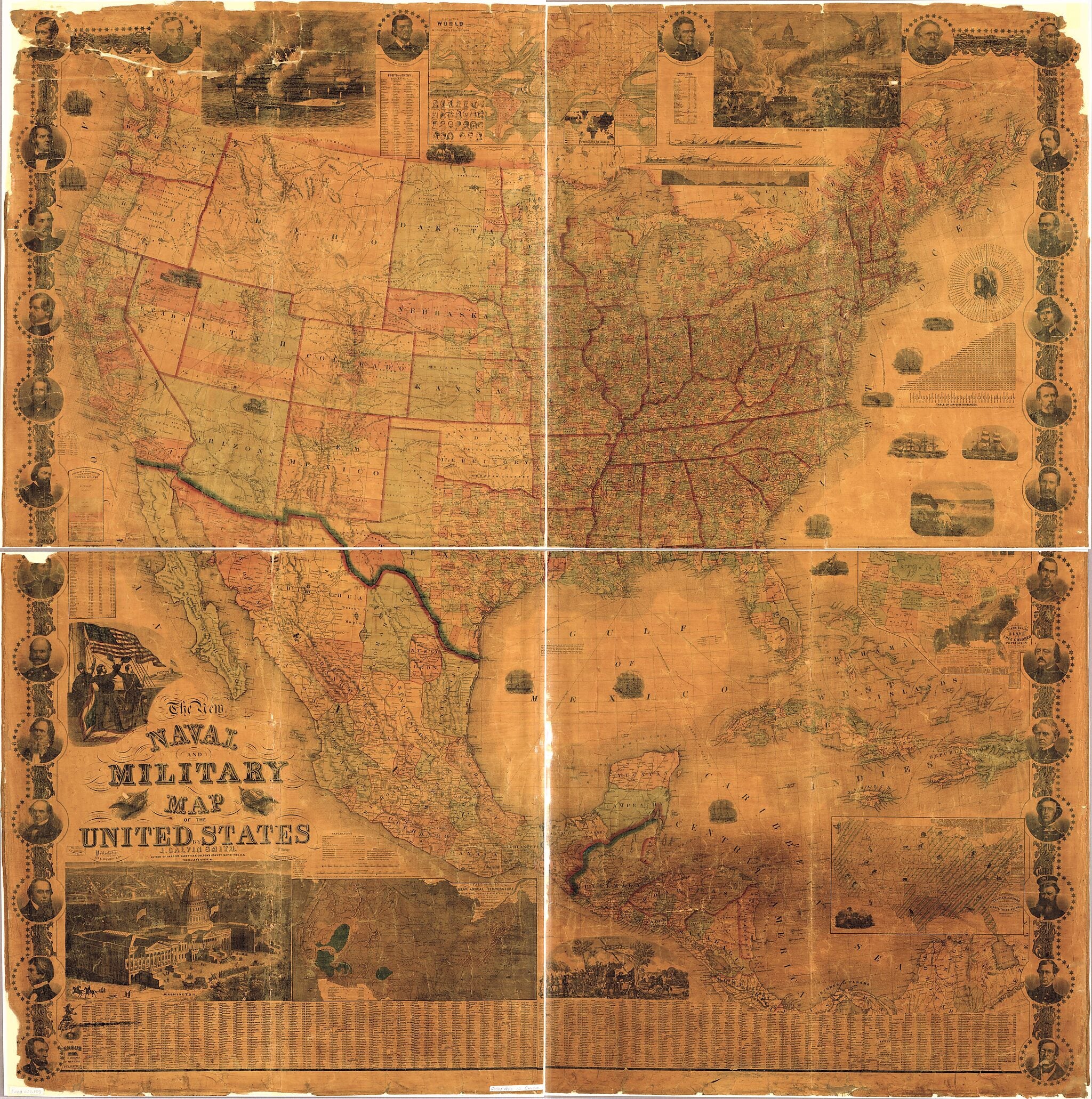
Created by J. Baker, J. Calvin (John Calvin) Smith, Robert Pearsall Smith in 1862.- Also covers southern Canada, Mexico, Central America, and the West Indies.
- Relief shown by hachures.
- "Entered according to Act of Congress in the year 1862 by Robert P. Smith ..."
- Prime meridians: Washington and Greenwich.
- Civil War Map
- Includes state/county population (1860 census) tables, view of Washington, various Civil War scenes, time difference table, "table of air-line distances," 3 profiles, and portraits of prominent Union military personnel along decorative border.
- Insets: Fall of rain and mean annual temperature with the mountains, plains & river systems of the United States -- Map of the world on Mercators projection -- Map showing the distribution of the slave and free colored population of the United States -- Map showing the distribution of staples in colors with the principle articles of export marked in the states severally, also the distribution of plants, trees, and animals.
- Sectioned and mounted on cardboard.
- Copy This map has some imperfections: small sections along edges of map missing; worn along fold lines. We'll do our best to restore the image before printing.
Map Subjects
United States
J. Baker
J. Calvin (John Calvin) Smith
Robert Pearsall Smith
1862
- For the best legibility, order your map in the original size or larger. Most maps have intricate detail and small text that is best appreciated when the print size hasn't been reduced.
- Sizes labeled "Fits a Standard Frame" will drop right into any frame that you purchase in that size. The sizes that we offer are commonly available online and at most retail stores.
- Our standard sizes are recommendations based on the aspect ratio of the original map, but still may require some added "white space" in one dimension to fit.
- Non-standard sizes will require custom framing, and we suggest taking your print to the frame shop of your choice after you receive it for the best results.
- Custom sizes are available, simply contact us for a quote.
Below is an approximation of the scale of a few standard sizes, and how they might appear in your space.

