
The New Naval and Military Map of the United States in 1862
- Regular price
-
$201.95 - Regular price
-
$196.95 - Sale price
-
$201.95
Buy one map, get any other map in our collection for 50% OFF! Add to cart to see discount.
Couldn't load pickup availability
About This Map
Discover the timeless beauty of our fine art quality printed reproduction of this antique map. Perfect for history enthusiasts, collectors, and interior decorators.
Restored with meticulous attention to detail by our team with over a decade of experience, this stunning reproduction captures the intricate artistry and historical significance of the original map.
Whether you're a collector or seeking a unique decor piece, this archival-quality map reproduction is a timeless addition to any space. Order now to bring history to life!
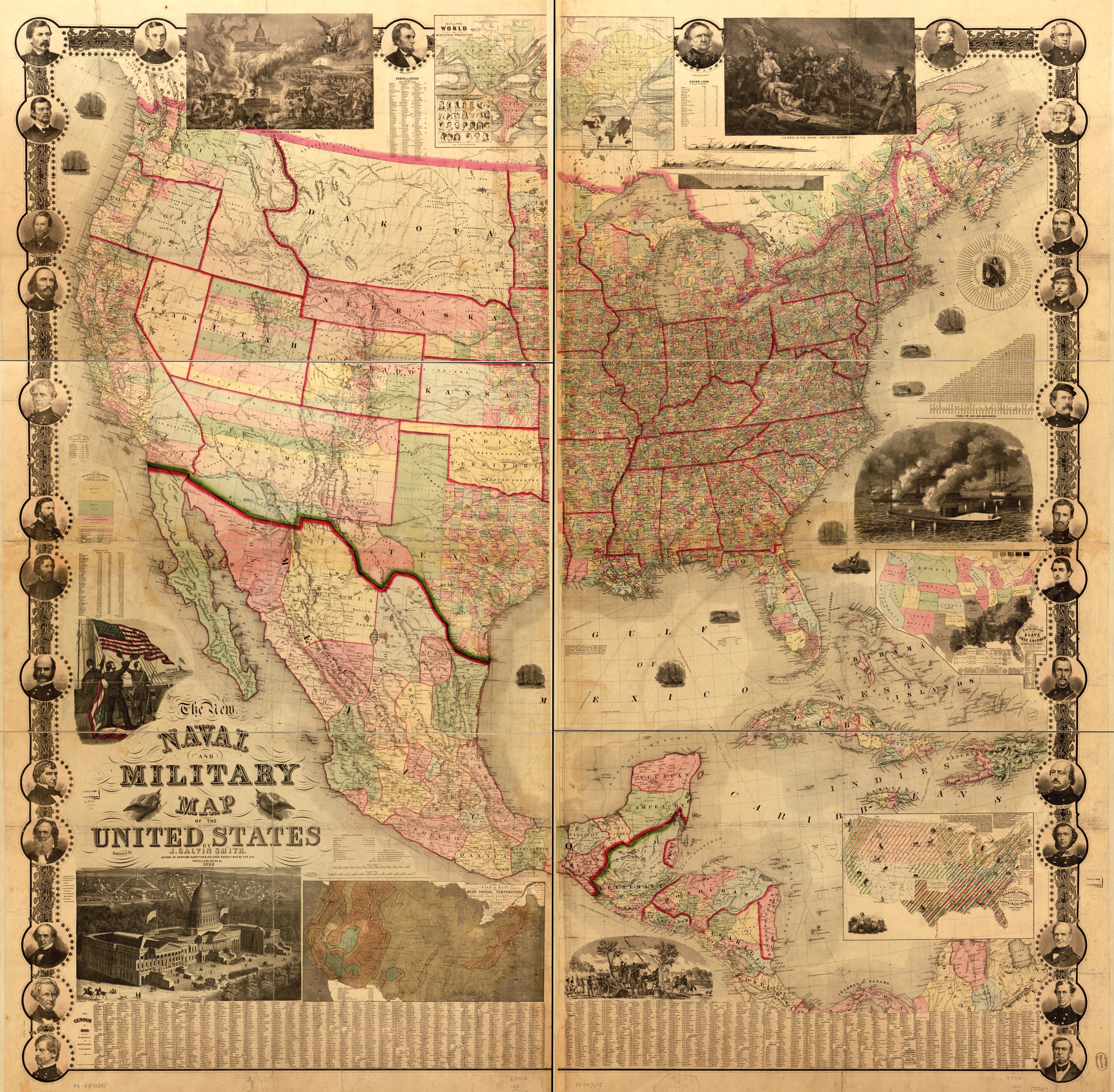
Old map of North America, United States.Created by J. Calvin (John Calvin) Smith in 1862.
- Scale ca. 1:3,275,000.
- Civil War Map
- "Entered according to Act of Congress in the year 1862 by Robert P. Smith."
- General map of the United States, Mexico, and Central America showing national, state, and county boundaries, cities and towns, mail routes and wagon roads, railroads built and in progress, canals, and relief by hachures. The "date of organization of counties," in some instances, is noted.
- Handwritten note on verso: No. 385 Deposited Oct. 27, 1862 (22245) Robert Persall [i.e. Pearsall] Smith proprietor.
- Insets (maps): Map showing the fall of rain and mean annual temperature with the mountains, plains & river systems of the United States. 20 x 39 cm.-Map of the world on Mercators projection [with an inset showing prevailing religions] 22 x 37 cm.-Map showing the distribution of the slave and free colored population of the United States. 21 x 28 cm.-Map showing the distribution of staples in colors with the principle articles of export marked in the states severally also the distribution of plants, trees, and animals by Thomas Meehan. 21 x 31 cm.
- Insets (views, some symbolic): The rescue of the Union. 19 x 31 cm.-Washington [city] 22 x 37.-Response of the army & navy. 21 x 20 cm.-The birth of the Union-battle of Bunker Hill. 19 x 31 cm.-Victory of the Monitor (2 guns) over the Merrimac (10 guns) March 9th 1862. 21 x 29 cm.-Scene of camp life. 11 x 24 cm.
- Includes tables giving "the census of 1860 in advance of official publication," size, population, and date of admission of states, "ports of entry in the United States," time differences, "air-line distances," "Union loss in the present rebellion," and distances of "pony express mail and telegraph routes."
- Includes profiles showing "Lieut. A. W. Whipples T. E. route for Pacific R. R. . . . ," 3 x 22 cm., "United States on latit[ud]e 42o N. from the Atlantic to the Pacific Ocean," 3 x 33 cm., and "Telegraphic plateau," Atlantic Ocean, 3 x 27 cm.
- Decorative border includes the following portraits of prominent Union figures: President Lincoln, Messrs. Jos. Holt, G. G. Welles, S. P. Chase, and S. Cameron, Governor Sprague, Generals McClellan, Anderson, Sigel, Lyon, Lander, Dix, Pope, Fremont, Burnside, Banks, Scott, Wool, Halleck, Mansfield, McDowell, Blenker, Rosecrans, and Butler, Colonels Ellsworth and Corcoran, and Commodores Du Pont, Stringham, Wilkes and Foote.
- Description derived from published bibliography.
- For the best legibility, order your map in the original size or larger. Most maps have intricate detail and small text that is best appreciated when the print size hasn't been reduced.
- Sizes labeled "Fits a Standard Frame" will drop right into any frame that you purchase in that size. The sizes that we offer are commonly available online and at most retail stores.
- Our standard sizes are recommendations based on the aspect ratio of the original map, but still may require some added "white space" in one dimension to fit.
- Non-standard sizes will require custom framing, and we suggest taking your print to the frame shop of your choice after you receive it for the best results.
- Custom sizes are available, simply contact us for a quote.
Below is an approximation of the scale of a few standard sizes, and how they might appear in your space.

