
The Portuguese Douro and the Adjacent Country : and So Much of the River As Can Be Made Navigable In Spain = O Douro Portuguez E Paiz Adjacente : Com Tanto Do Rio Quanto Se Pode Tornar Navegavel Em Espanha in 1852
- Regular price
-
$281.95 - Regular price
-
$276.95 - Sale price
-
$281.95
Buy one map, get any other map in our collection for 50% OFF! Add to cart to see discount.
Couldn't load pickup availability
About This Map
Discover the timeless beauty of our fine art quality printed reproduction of this antique map. Perfect for history enthusiasts, collectors, and interior decorators.
Restored with meticulous attention to detail by our team with over a decade of experience, this stunning reproduction captures the intricate artistry and historical significance of the original map.
Whether you're a collector or seeking a unique decor piece, this archival-quality map reproduction is a timeless addition to any space. Order now to bring history to life!
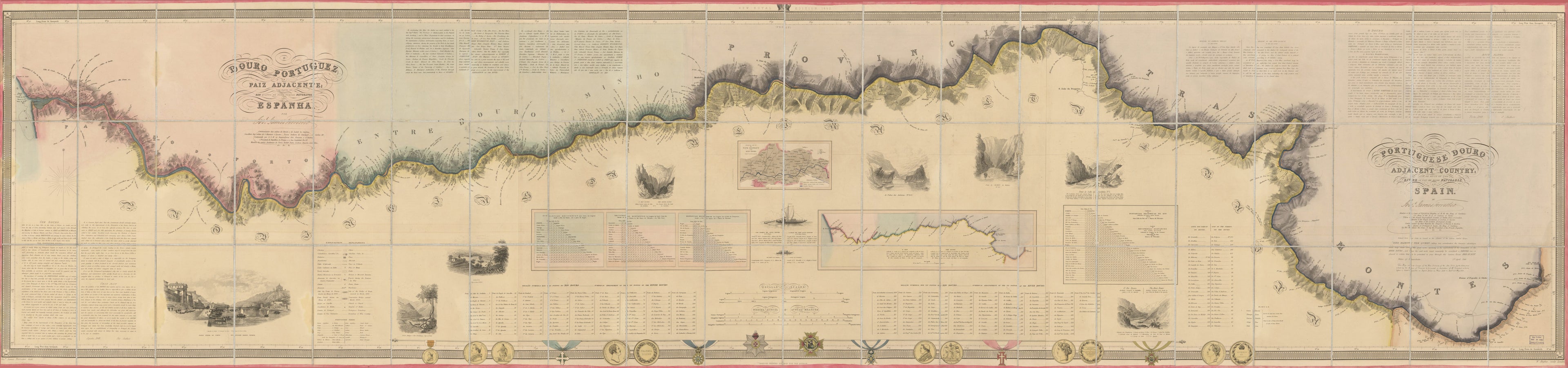
Old map of Duero River, Portugal, Spain.Created by Joseph James Forrester, William Hughes in 1852.
- Relief shown by hachures.
- In English and Portuguese.
- Author's name signed in statement of responsibility.
- Manuscript author's name and the following not added in ink below English title: This map, and the surveys of the Wine-Districts of the Alto-Douro, by the author, were ordered by the House of Commons to be printed in illustration of Mr. Forrester's evidence before a Select Committee on Import Dutirs on Wines, held in April and May 1852.
- Inset maps: Geological View of the Wine District of Alto-Douro -- O rio = The river.
- At top of the map: New Royal Edition, 1852.
- In bottom margin: London printed solely for the author.
- Includes text, distance tables, references, 2 illustrations of boats with descriptive information, illustrations of medals along lower border, 2 insets and 8 vignettes.
- Vignettes: Ponte pensil do Porto = Suspension bridge, Oporto -- Porto Antigo-e Rio Bestança -- Regôa -- O Rio Douro huma legoa acima do Salto da Sardinha = The River Douro one league above the Salto da Sardinha -- As Pedras das Anchoras -- Ponto do Cachão da Baleira -- Ponto do Salto da Sardinha -- O Rio Douro divindo Portugal do Espanha junta a foz do Agueda = The River Douro dividing Portugal from Spain as seen from the mouth of the Agueda.
- For the best legibility, order your map in the original size or larger. Most maps have intricate detail and small text that is best appreciated when the print size hasn't been reduced.
- Sizes labeled "Fits a Standard Frame" will drop right into any frame that you purchase in that size. The sizes that we offer are commonly available online and at most retail stores.
- Our standard sizes are recommendations based on the aspect ratio of the original map, but still may require some added "white space" in one dimension to fit.
- Non-standard sizes will require custom framing, and we suggest taking your print to the frame shop of your choice after you receive it for the best results.
- Custom sizes are available, simply contact us for a quote.
Below is an approximation of the scale of a few standard sizes, and how they might appear in your space.
