
The Province of Tierra Firme and the New Kingdom of Granada and Popayán. (Terra Firma Et Novum Regnum Granatense Et Popayan) 1631
- Regular price
-
$57.95 - Regular price
-
$40.95 - Sale price
-
$57.95
Buy one map, get any other map in our collection for 50% OFF! Add to cart to see discount.
Couldn't load pickup availability
About This Map
Discover the timeless beauty of our fine art quality printed reproduction of this antique map. Perfect for history enthusiasts, collectors, and interior decorators.
Restored with meticulous attention to detail by our team with over a decade of experience, this stunning reproduction captures the intricate artistry and historical significance of the original map.
Whether you're a collector or seeking a unique decor piece, this archival-quality map reproduction is a timeless addition to any space. Order now to bring history to life!
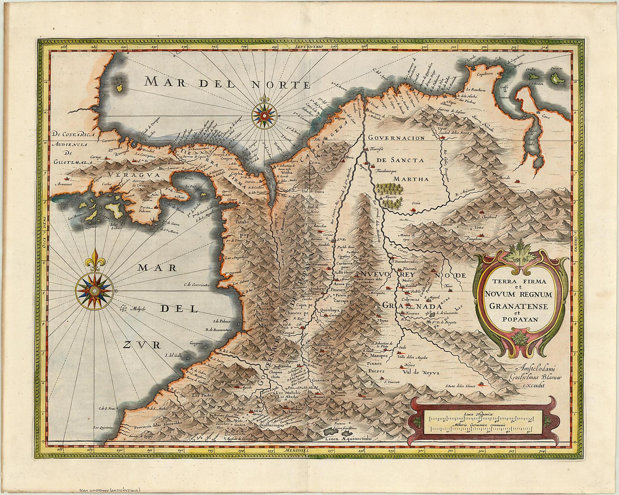
Old map of Colombia, Costa Rica, Panama.-1638) shows Central America and the northwestern part of South America, including all or parts of Colombia, Ecuador, and Venezuela. A Dutch text on the reverse of the map explains the geography of the regions depicted, which encompassed the Spanish viceroyalty of New Granada and the province of Popayán, which took its name from the colonial city located at the foot of Volcán Puracé in the Cordillera Central of the Andes. The map shows rivers and other geographic features, along with towns and missions. Relief is shown pictorially. The map has two distance scales, Spanish leagues and German miles. Blaeu places a hand-colored compass rose in the Caribbean Sea (labeled the Northern Ocean, the term for the Atlantic in use at the time), and another, slightly larger one in the Pacific (labeled the Southern Ocean). The title, scales, Blaeu's signature, and other information on the map are in Latin, but place-names are in Spanish. Blaeu was a leading Dutch cartographer and map publisher and the founder of a family of distinguished mapmakers that included his sons Joan and Cornelis. Born in the Netherlands in 1571, between 1594 and 1596 Blaeu studied in Denmark under the astronomer Tycho Brahe, where he developed skills as an instrument and globe maker. Upon returning to Amsterdam, he founded the family map company. In 1608 he was appointed chief hydrographer of the Vereenigde Oost-Indische Compagnie (United East Indian Company), a position he held until his death. The use of the compass rose and the careful marking of capes, islands, and shallows along the coasts reflect his interest in marine cartography.
Created by Willem Janszoon Blaeu in 1631.
- Title devised, in English, by Library staff.
- "Scale 1:4,000,000"--Note extracted from World Digital Library.
- Original resource extent: 1 map : color ; 36 x 47 centimeters.
- Original resource at: University of Wisconsin-Milwaukee Libraries.
- Content in Latin and Dutch and Spanish.
- Description based on data extracted from World Digital Library, which may be extracted from partner institutions.
Map Subjects
Colombia
Costa Rica
Panama
Territories And Possessions
Willem Janszoon Blaeu
1631
- For the best legibility, order your map in the original size or larger. Most maps have intricate detail and small text that is best appreciated when the print size hasn't been reduced.
- Sizes labeled "Fits a Standard Frame" will drop right into any frame that you purchase in that size. The sizes that we offer are commonly available online and at most retail stores.
- Our standard sizes are recommendations based on the aspect ratio of the original map, but still may require some added "white space" in one dimension to fit.
- Non-standard sizes will require custom framing, and we suggest taking your print to the frame shop of your choice after you receive it for the best results.
- Custom sizes are available, simply contact us for a quote.
Below is an approximation of the scale of a few standard sizes, and how they might appear in your space.

