
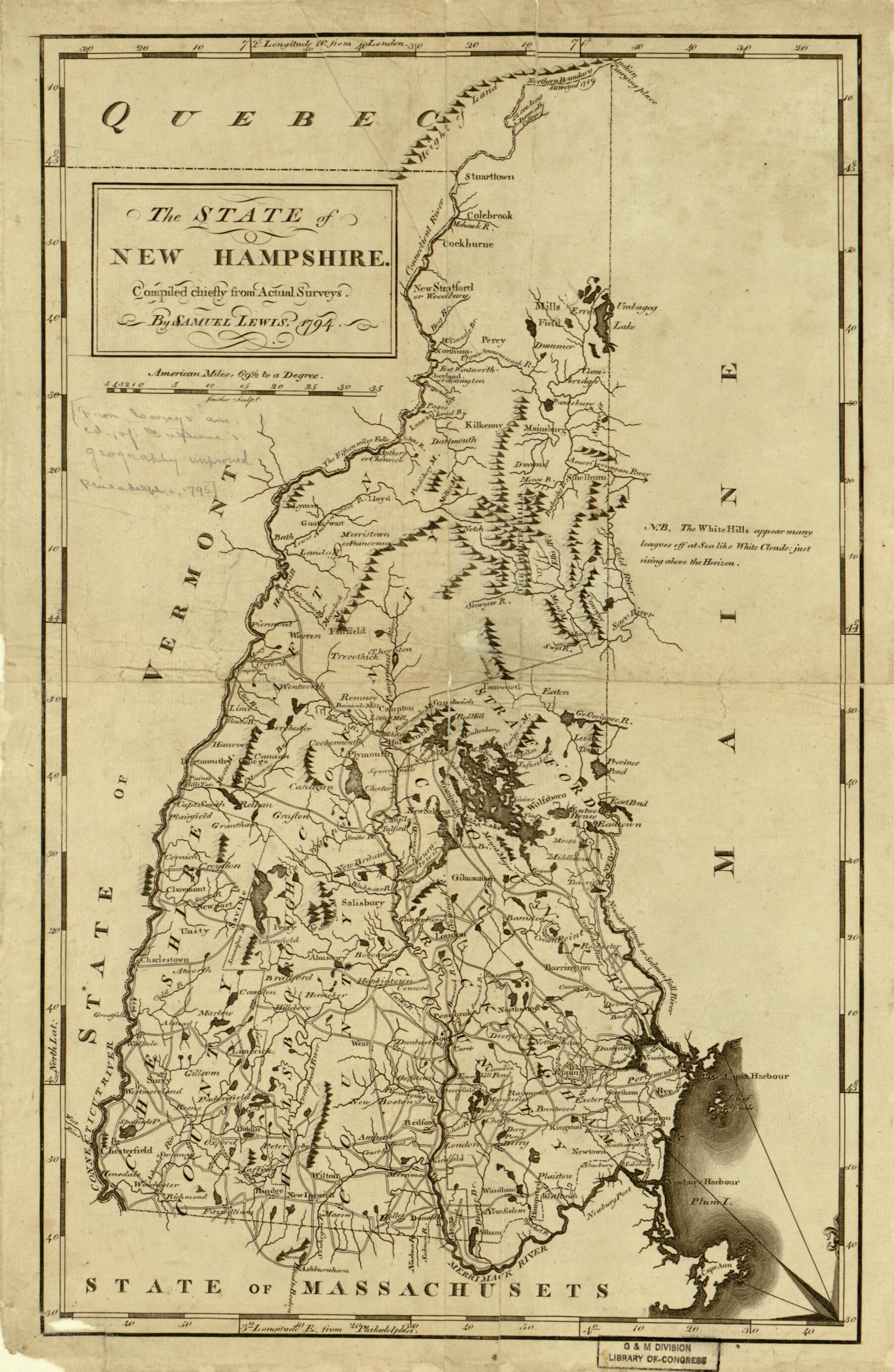
The State of New Hampshire. Compiled Chiefly from Actual Surveys 1794
- Regular price
-
$49.95 - Regular price
-
$34.95 - Sale price
-
$49.95
Buy one map, get any other map in our collection for 50% OFF! Add to cart to see discount.
Couldn't load pickup availability
About This Map
Discover the timeless beauty of our fine art quality printed reproduction of this antique map. Perfect for history enthusiasts, collectors, and interior decorators.
Restored with meticulous attention to detail by our team with over a decade of experience, this stunning reproduction captures the intricate artistry and historical significance of the original map.
Whether you're a collector or seeking a unique decor piece, this archival-quality map reproduction is a timeless addition to any space. Order now to bring history to life!
Old map of New Hampshire, United States.1822), a Philadelphia draftsman and engraver, for inclusion in General Atlas for Carey's Edition of Guthrie's Geography Improved, published in Philadelphia in 1795. It shows the five counties of New Hampshire-Cheshire, Grafton, Hillsborough, Rockingham, and Stratford-with their boundaries, principal towns and settlements, roads and waterways, mountains, and islands. Much of the map's northern region is blank, with a note across the top, "Indian carrying place" (canoe portage). Lewis identifies the present-day White Mountains as the White Hills, which he describes as appearing "many leagues off at Sea like White Clouds just rising above the Horizon." Dartmouth College, founded in 1769, is indicated on the left side of the map. James Smither of Philadelphia engraved the map. Mathew Carey (1760-1839) was an immigrant from Ireland who worked as a publisher in Philadelphia, specializing in maps, atlases, and works of geography. In 1795 he issued the first atlas published in the United States, the American Atlas. Early American publishers such as Carey were not restricted by international copyright agreements and reused European sources to print extensive atlases and geography texts. Carey combined William Guthrie's European maps, originally published in London in 1770, with updated maps of the United States to produce Guthrie's Geography Improved. The map is from the Rochambeau Collection at the Library of Congress, which consists of 40 manuscript maps, 26 printed maps, and a manuscript atlas that belonged to Jean-Baptiste-Donatien de Vimeur, comte de Rochambeau (1725-1807), commander in chief of the French expeditionary army (1780-82) during the American Revolution. Some of the maps were used by Rochambeau during the war. Dating from 1717 to 1795, the maps cover much of eastern North America, from Newfoundland and Labrador in the north to Haiti in the south. The collection includes maps of cities, maps showing Revolutionary War battles and military campaigns, and early state maps from the 1790s." World Digital Library.
Created by Samuel Lewis, James Smither in 1794.
- Prime meridian: London and Philadelphia.
- Relief shown pictorially.
- Scale ca. 1:700,000.
- LAC ddw 2023-06-13 update (1 card)
- For the best legibility, order your map in the original size or larger. Most maps have intricate detail and small text that is best appreciated when the print size hasn't been reduced.
- Sizes labeled "Fits a Standard Frame" will drop right into any frame that you purchase in that size. The sizes that we offer are commonly available online and at most retail stores.
- Our standard sizes are recommendations based on the aspect ratio of the original map, but still may require some added "white space" in one dimension to fit.
- Non-standard sizes will require custom framing, and we suggest taking your print to the frame shop of your choice after you receive it for the best results.
- Custom sizes are available, simply contact us for a quote.
Below is an approximation of the scale of a few standard sizes, and how they might appear in your space.

