
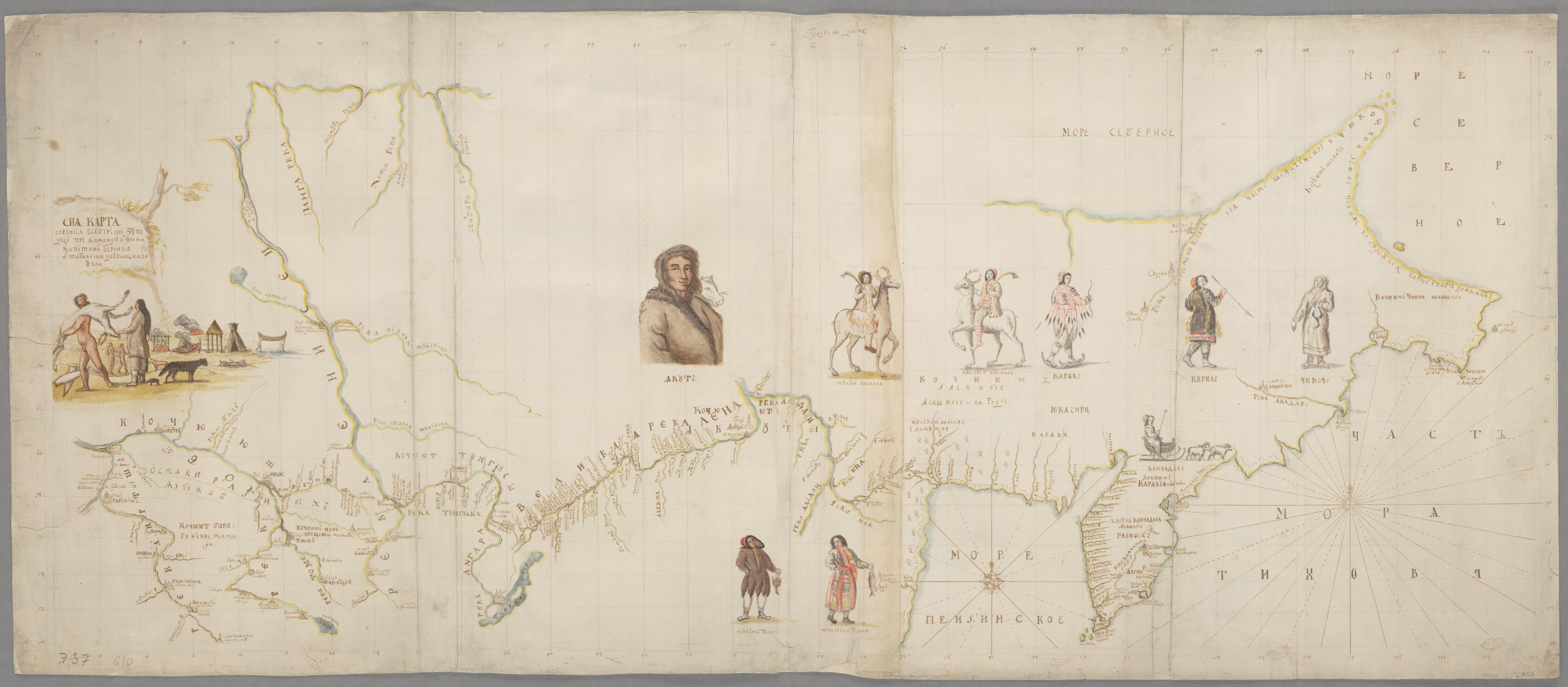
This Chart Was Compiled On the Siberian Expedition Under the Command of Navy Captain Bering from Tobolsk to the Chukotkan Corner 1725
- Regular price
-
$49.95 - Regular price
-
$34.95 - Sale price
-
$49.95
Buy one map, get any other map in our collection for 50% OFF! Add to cart to see discount.
Couldn't load pickup availability
About This Map
Discover the timeless beauty of our fine art quality printed reproduction of this antique map. Perfect for history enthusiasts, collectors, and interior decorators.
Restored with meticulous attention to detail by our team with over a decade of experience, this stunning reproduction captures the intricate artistry and historical significance of the original map.
Whether you're a collector or seeking a unique decor piece, this archival-quality map reproduction is a timeless addition to any space. Order now to bring history to life!
Old map of Russian Federation.-1741) was born in Denmark but spent most of his adult life in the Russian navy. In 1725, Tsar Peter I (Peter the Great) instructed Bering to undertake an expedition to find the point at which Siberia connected to America. In what became known as the First Kamchatka Expedition (1725--30), Bering traveled overland from St. Petersburg via Tobolsk to the Kamchatka Peninsula, where he had a ship, the Saint Gabriel, constructed. In 1728 he sailed north along the coast of the Kamchatka Peninsula. In August of that year he passed between the two continents through the strait that would later bear his name, but he never spotted the Alaskan coast and was unable to determine whether Asia and North America were connected or separated by water. Upon his return to St. Petersburg, Bering presented to Empress Anna (reigned 1730--40) the maps prepared during the expedition. Unlike other maps of the expedition, this hand-drawn map contains ethnographic drawings, some of the first images of the inhabitants of Siberia. Peoples represented on the map include the Yakuts, Koriaks, Chukchi, Evenks (formerly known as the Tungus or Tunguz), Kamchadal (or Itelmen), and the Ainu people of the Kuril Islands. The Second Kamchatka Expedition of 1733--43, also led by Bering, finally resulted in the European discovery of Alaska and confirmation that Siberia and Alaska were indeed separated by water.
Created by Vitus Jonassen Bering in 1725.
- Title devised, in English, by Library staff.
- Original resource extent: 1 handdrawn map ; 52 x 130 centimeters.
- Original resource at: National Library of Sweden.
- Content in Russian.
- Description based on data extracted from World Digital Library, which may be extracted from partner institutions.
- For the best legibility, order your map in the original size or larger. Most maps have intricate detail and small text that is best appreciated when the print size hasn't been reduced.
- Sizes labeled "Fits a Standard Frame" will drop right into any frame that you purchase in that size. The sizes that we offer are commonly available online and at most retail stores.
- Our standard sizes are recommendations based on the aspect ratio of the original map, but still may require some added "white space" in one dimension to fit.
- Non-standard sizes will require custom framing, and we suggest taking your print to the frame shop of your choice after you receive it for the best results.
- Custom sizes are available, simply contact us for a quote.
Below is an approximation of the scale of a few standard sizes, and how they might appear in your space.
