
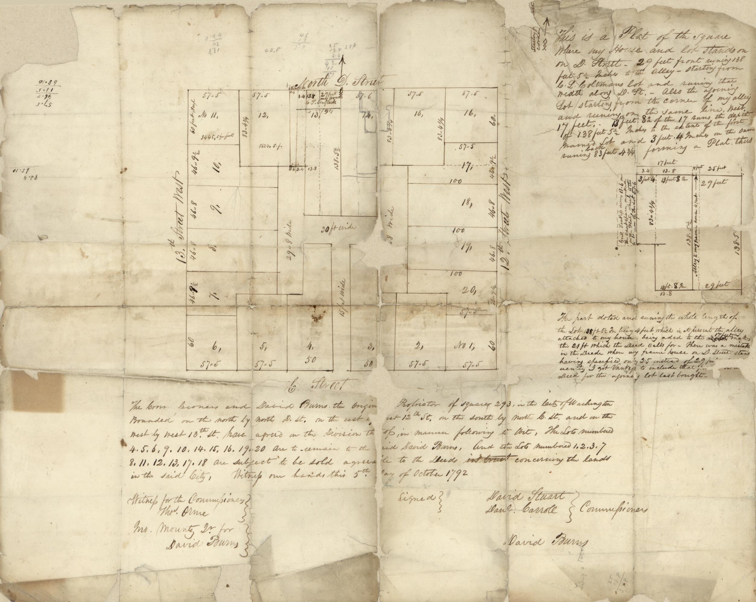
This Is a Plat of the Square Where My House and Lot Stands On On sic D Street : 29 Feet Front Runing sic 138 Feet 5 1/2 Inches to the Alley ... Forming a Plat Thus : part of N.W. Washington D.C. (Plat of the Square Where My Property Is On) 1792
- Regular price
-
$52.95 - Regular price
-
$36.95 - Sale price
-
$52.95
Buy one map, get any other map in our collection for 50% OFF! Add to cart to see discount.
Couldn't load pickup availability
About This Map
Discover the timeless beauty of our fine art quality printed reproduction of this antique map. Perfect for history enthusiasts, collectors, and interior decorators.
Restored with meticulous attention to detail by our team with over a decade of experience, this stunning reproduction captures the intricate artistry and historical significance of the original map.
Whether you're a collector or seeking a unique decor piece, this archival-quality map reproduction is a timeless addition to any space. Order now to bring history to life!
Old map of District of Columbia, United States, Washington, Washington D.C..Created by Daniel Carroll, District of Columbia. Board of Commissioners, David Stuart in 1792.
- Cadastral survey map of the square bounded by 13th St. N.W., D St. N.W., 12th St. N.W., and C St. N.W. in central Washington D.C. (square 293).
- Shows lot lines, lot and alley dimensions, and lot numbers.
- In text at bottom: Witness our hands this 5th day of October 1792.
- At lower left in handwriting: Witness for the Commissioners--Thos. Orme, Jno. Mounty Jr. for David Burns.
- Pen-and-ink with lead pencil annotations.
- Sheet originally folded to 21 x 9 cm.
- Watermark: J. Robeson, P[hi]la.
- This map has some imperfections: torn at fold lines, lightly stained, missing sections at edges and fold lines (including small portions of plat and text). We'll do our best to restore the image before printing.
- Includes inset map of 2 lots and handwritten texts.
- Ms. pencil and ink annotations on verso.
- Gift; Samuel A. Bleicher, Arlington, VA; July 2002.
- Acquisitions control no.: 2003-31
- For the best legibility, order your map in the original size or larger. Most maps have intricate detail and small text that is best appreciated when the print size hasn't been reduced.
- Sizes labeled "Fits a Standard Frame" will drop right into any frame that you purchase in that size. The sizes that we offer are commonly available online and at most retail stores.
- Our standard sizes are recommendations based on the aspect ratio of the original map, but still may require some added "white space" in one dimension to fit.
- Non-standard sizes will require custom framing, and we suggest taking your print to the frame shop of your choice after you receive it for the best results.
- Custom sizes are available, simply contact us for a quote.
Below is an approximation of the scale of a few standard sizes, and how they might appear in your space.

