
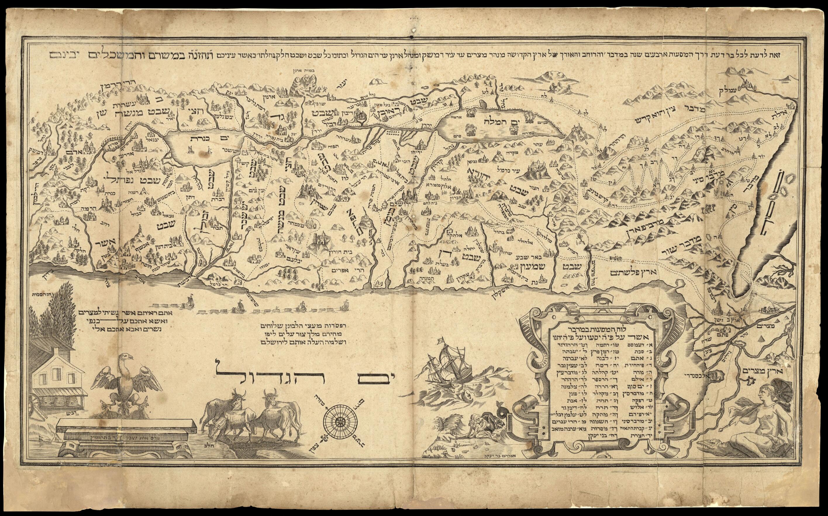
This is Being Produced So That All Can Know the Route of the Travels of the Israelites 40 Years In the Desert through the Width and Length of the Holy Land from the Nile to the City of Damascus, from the Arnon Valley to the Mediterranean Sea, and In I...
- Regular price
-
$61.95 - Regular price
-
$43.95 - Sale price
-
$61.95
Buy one map, get any other map in our collection for 50% OFF! Add to cart to see discount.
Couldn't load pickup availability
About This Map
Discover the timeless beauty of our fine art quality printed reproduction of this antique map. Perfect for history enthusiasts, collectors, and interior decorators.
Restored with meticulous attention to detail by our team with over a decade of experience, this stunning reproduction captures the intricate artistry and historical significance of the original map.
Whether you're a collector or seeking a unique decor piece, this archival-quality map reproduction is a timeless addition to any space. Order now to bring history to life!
Old map of Israel.Jacob, a convert to Judaism, based on an earlier map by Christiaan van Adrichem (1533-85), and reproduced in the Amsterdam Haggadah. The map features Biblical illustrations, among them depictions of the story of Jonah and the whale, King Solomon's fleet carrying the cedar trees for the construction of the temple in Jerusalem, and beehives and cows symbolizing the milk and honey of the Promised Land. The Amsterdam Haggadah was the first Haggadah to include copperplate engravings, and was widely copied and distributed throughout Europe.
Created by Abraham Ben Jacob (17th Century) in 1695.
- Title devised, in English, by Library staff.
- Original resource extent: Copperplate ; 262 x 480 millimeters.
- Original resource at: National Library of Israel.
- Content in Hebrew.
- Description based on data extracted from World Digital Library, which may be extracted from partner institutions.
- For the best legibility, order your map in the original size or larger. Most maps have intricate detail and small text that is best appreciated when the print size hasn't been reduced.
- Sizes labeled "Fits a Standard Frame" will drop right into any frame that you purchase in that size. The sizes that we offer are commonly available online and at most retail stores.
- Our standard sizes are recommendations based on the aspect ratio of the original map, but still may require some added "white space" in one dimension to fit.
- Non-standard sizes will require custom framing, and we suggest taking your print to the frame shop of your choice after you receive it for the best results.
- Custom sizes are available, simply contact us for a quote.
Below is an approximation of the scale of a few standard sizes, and how they might appear in your space.
