
Time Zone Chart of the World 1927
- Regular price
-
$171.95 - Regular price
-
$166.95 - Sale price
-
$171.95
Buy one map, get any other map in our collection for 50% OFF! Add to cart to see discount.
Couldn't load pickup availability
About This Map
Discover the timeless beauty of our fine art quality printed reproduction of this antique map. Perfect for history enthusiasts, collectors, and interior decorators.
Restored with meticulous attention to detail by our team with over a decade of experience, this stunning reproduction captures the intricate artistry and historical significance of the original map.
Whether you're a collector or seeking a unique decor piece, this archival-quality map reproduction is a timeless addition to any space. Order now to bring history to life!
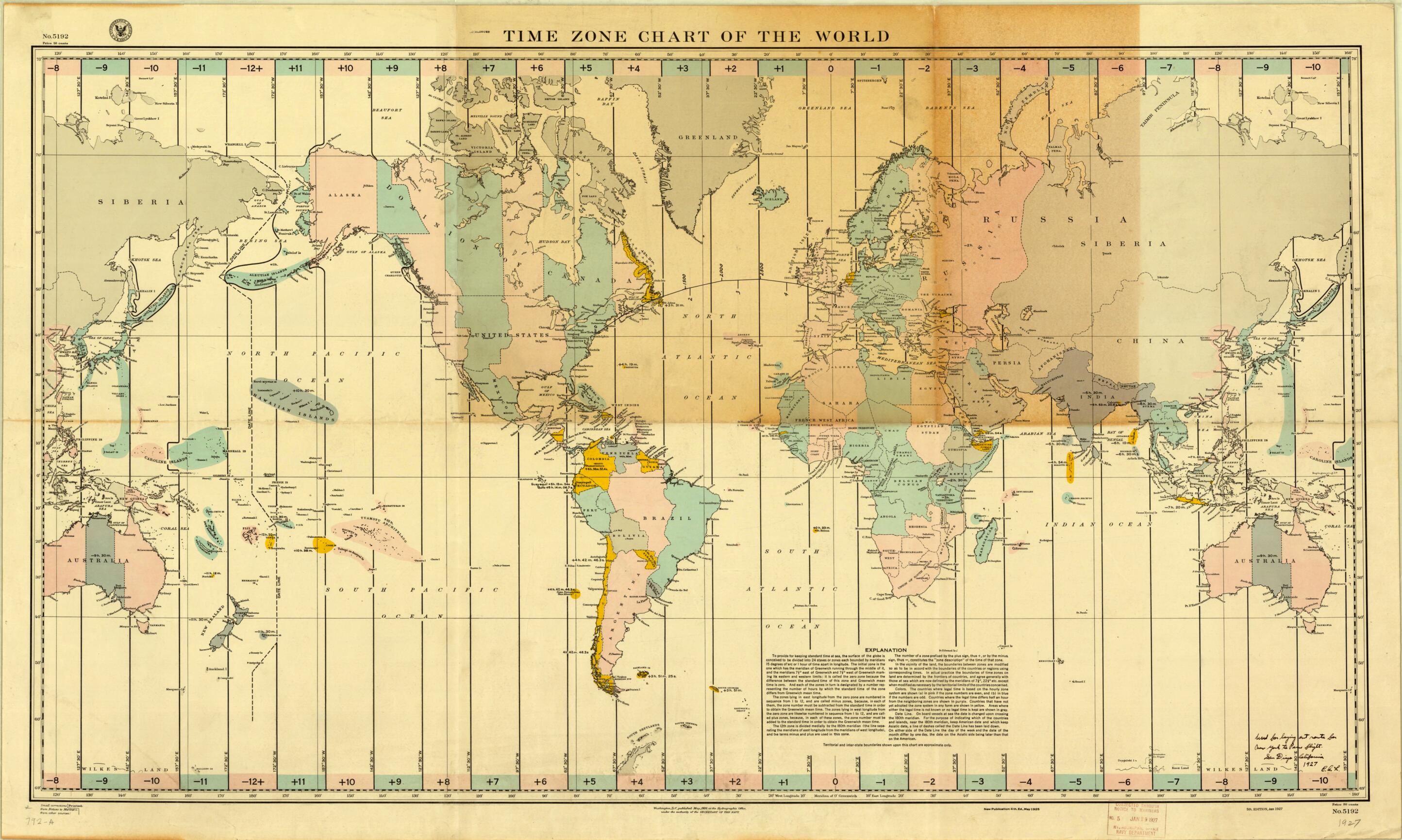
-74) was the American aviator who made the first nonstop solo flight across the Atlantic Ocean on May 21--22, 1927. While Ryan Airlines of San Diego, California, was constructing his plane, the Spirit of St. Louis, Lindbergh was busy obtaining charts and plotting his course. In his book The Spirit of St. Louis (1953), Lindbergh described purchasing a number of charts of the North Atlantic at a store in San Pedro, including this time-zone chart of the world: "The salesman pulls out two oblong sheets. They're Mercator's projections and--yes, I'm in luck--they extend inland far enough to include New York and Paris. Then, like stumbling over a nugget of gold, I see a gnomonic projection covering them both. . . . Rummaging around still farther, I locate a time-zone chart of the world, a chart of magnetic variation, and others showing prevailing winds over the Atlantic for April, May, and June. I buy them all." Lindbergh planned his route on this time-zone chart in 500 mile-long segments that follow the great-circle route from New York to Paris. He did not indicate the number of charts he bought in San Pedro, but it appears that he purchased the two Mercator projection charts, upon which he plotted his intended course in 100-mile segments and which were actually taken on the flight.Created by Charles A. (Charles Augustus) Lindbergh, United States. Hydrographic Office in 1927.
- Title devised, in English, by Library staff.
- "Scale 1:28,500,000. 5th edition. H.O. chart no. 5192."--Note extracted from World Digital Library.
- Original resource extent: 1 map : color, annotated ; 67 x 119 centimeters.
- Original resource at: University of Wisconsin-Milwaukee Libraries.
- Content in English.
- Description based on data extracted from World Digital Library, which may be extracted from partner institutions.
- For the best legibility, order your map in the original size or larger. Most maps have intricate detail and small text that is best appreciated when the print size hasn't been reduced.
- Sizes labeled "Fits a Standard Frame" will drop right into any frame that you purchase in that size. The sizes that we offer are commonly available online and at most retail stores.
- Our standard sizes are recommendations based on the aspect ratio of the original map, but still may require some added "white space" in one dimension to fit.
- Non-standard sizes will require custom framing, and we suggest taking your print to the frame shop of your choice after you receive it for the best results.
- Custom sizes are available, simply contact us for a quote.
Below is an approximation of the scale of a few standard sizes, and how they might appear in your space.
