
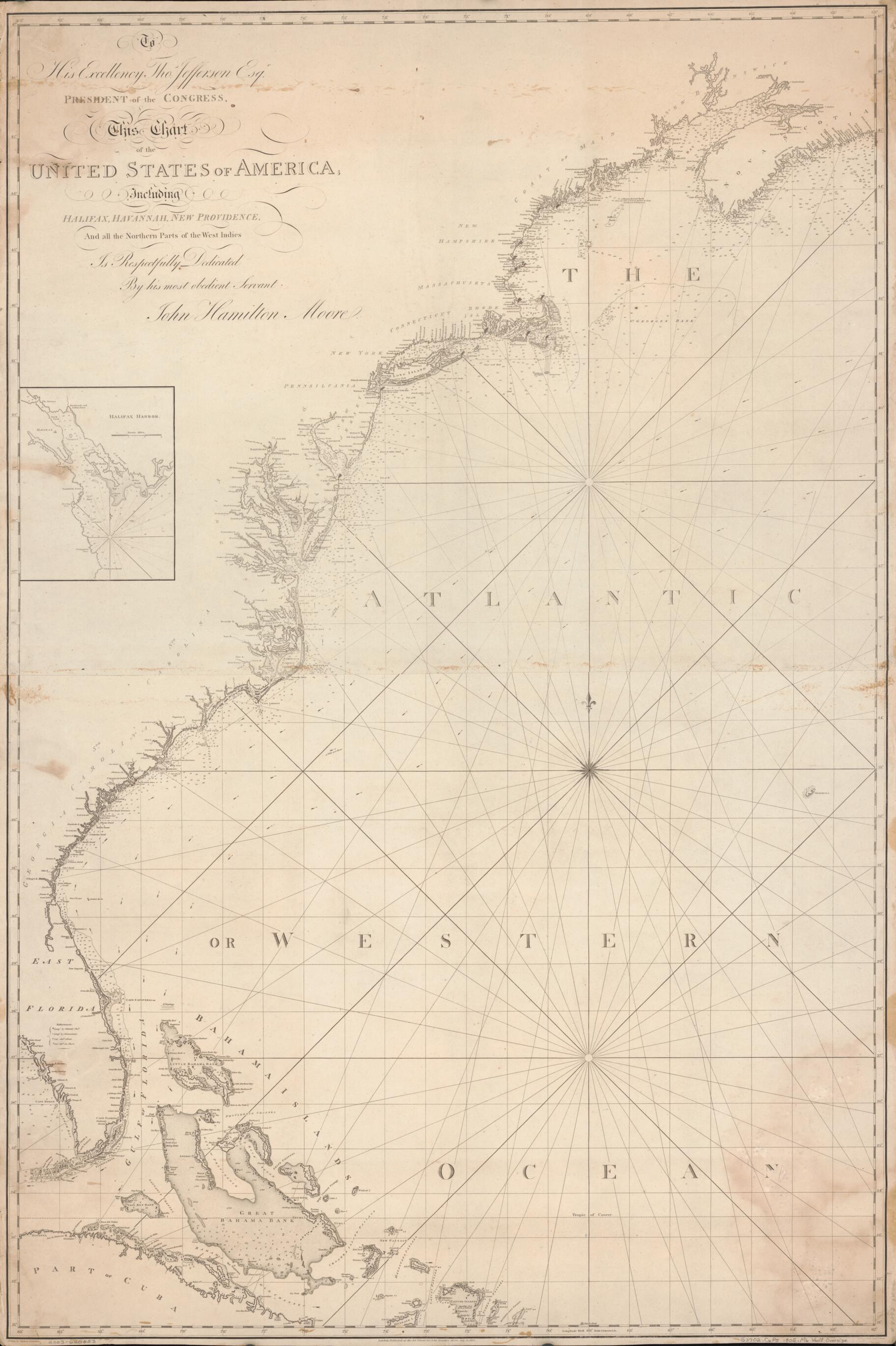
To His Excellency Thos. Jefferson, Esqr., President of the Congress, This Chart of the United States of America : Including Halifax, Havannah Havana, New Providence, and All the Northern Parts of the West Indies 1805
- Regular price
-
$159.95 - Regular price
-
$154.95 - Sale price
-
$159.95
Buy one map, get any other map in our collection for 50% OFF! Add to cart to see discount.
Couldn't load pickup availability
About This Map
Discover the timeless beauty of our fine art quality printed reproduction of this antique map. Perfect for history enthusiasts, collectors, and interior decorators.
Restored with meticulous attention to detail by our team with over a decade of experience, this stunning reproduction captures the intricate artistry and historical significance of the original map.
Whether you're a collector or seeking a unique decor piece, this archival-quality map reproduction is a timeless addition to any space. Order now to bring history to life!
Old map of Atlantic Coast, Atlantic Provinces, Bahamas, Canada, Cuba, Gulf Stream, Halifax Harbour, Nova Scotia, United States.Created by J. Foss (Joseph Foss) Dessiou, Thomas Jefferson, John Hamilton Moore, R. Penny in 1805.
- Covers coast of United States from southern end of Tampa Bay, Florida, to eastern end of Maine.
- Also covers coastal areas in New Brunswick, Nova Scotia, Bahamas, and Cuba and covers western portion of Gulf Stream.
- Depths shown by soundings.
- Lighthouses highlighted with red ink.
- Shows direction of Gulf Stream with arrows and gives information on speed of Gulf Stream in miles per hour.
- In lower center margin: London. Published as the act directs for John Hamilton Moore, July 12, 1805.
- In lower right margin: R. Penny, sculp., [undeciperable word] Britain.
- Includes notes and inset of Halifax harbor that provides soundings.
- On verso written in black ink: Hamilton Moore's North American coast.
- Also on verso written in black ink: United States of America.
- This map has some imperfections: stains, abrasions, and small tears along edges. We'll do our best to restore the image before printing.
- Acquisitions control no.: 99-105
- For the best legibility, order your map in the original size or larger. Most maps have intricate detail and small text that is best appreciated when the print size hasn't been reduced.
- Sizes labeled "Fits a Standard Frame" will drop right into any frame that you purchase in that size. The sizes that we offer are commonly available online and at most retail stores.
- Our standard sizes are recommendations based on the aspect ratio of the original map, but still may require some added "white space" in one dimension to fit.
- Non-standard sizes will require custom framing, and we suggest taking your print to the frame shop of your choice after you receive it for the best results.
- Custom sizes are available, simply contact us for a quote.
Below is an approximation of the scale of a few standard sizes, and how they might appear in your space.

