
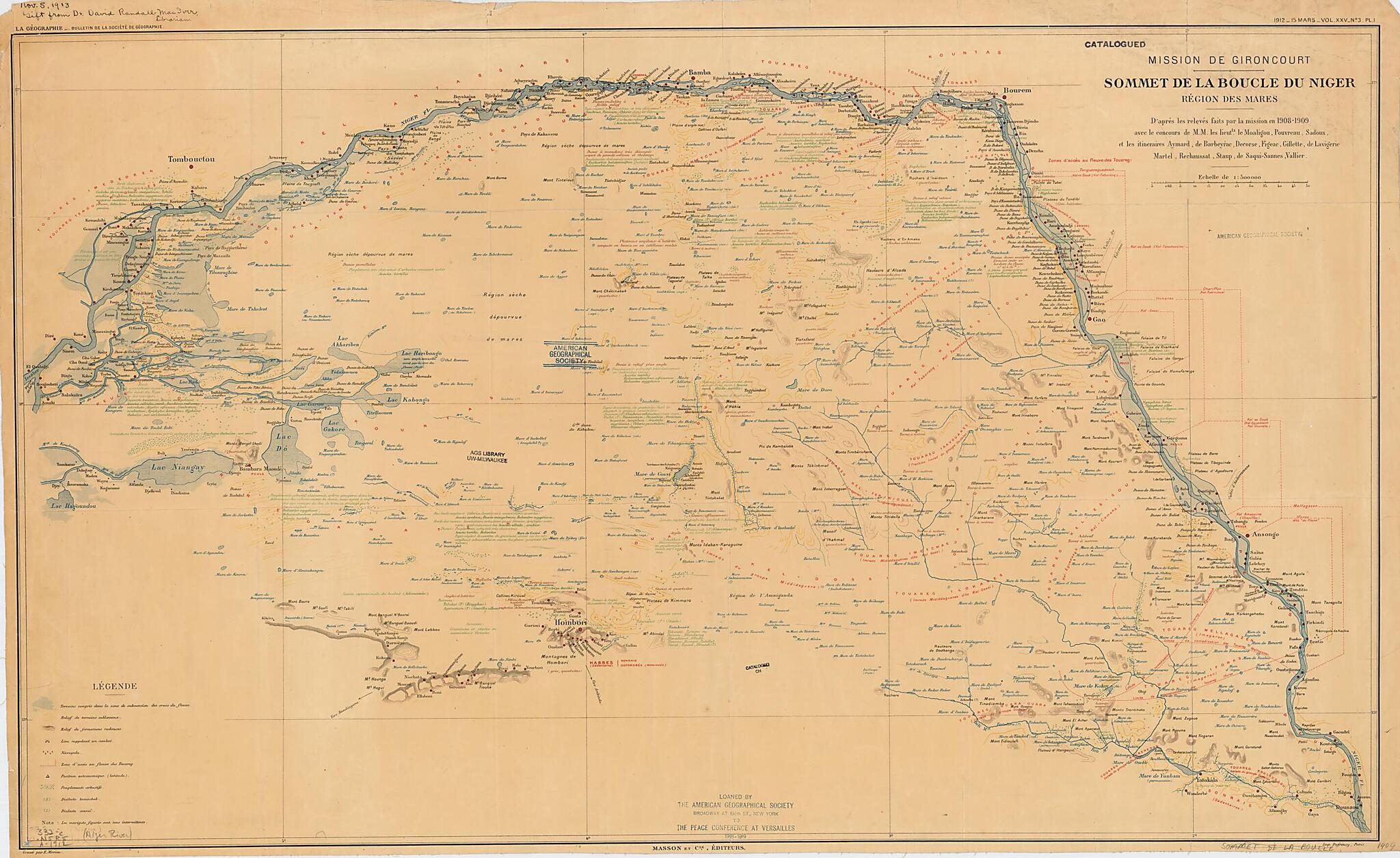
Top of the Niger Bend, Lakes Region, As Observed During the Gironcourt Mission. (Mission De Gironcourt. Sommet De La Boucle Du Niger. Région Des Mares) 1912
- Regular price
-
$95.95 - Regular price
-
$90.95 - Sale price
-
$95.95
Buy one map, get any other map in our collection for 50% OFF! Add to cart to see discount.
Couldn't load pickup availability
About This Map
Discover the timeless beauty of our fine art quality printed reproduction of this antique map. Perfect for history enthusiasts, collectors, and interior decorators.
Restored with meticulous attention to detail by our team with over a decade of experience, this stunning reproduction captures the intricate artistry and historical significance of the original map.
Whether you're a collector or seeking a unique decor piece, this archival-quality map reproduction is a timeless addition to any space. Order now to bring history to life!
Old map of Mali, Niger.day Mali) where the Niger heads in a northeasterly direction toward the Sahara Desert before turning south near the town of Bourem and resuming its course toward the Atlantic Ocean. The map was produced by the Gironcourt Mission of 1908-9, an expedition to the region sponsored by the French government and led by the French engineer and agronomist Georges de Gironcourt (1878-1960). Mali was at that time part of the territory of Senegambia-Niger, administered by the French as part of the Government-General of West Africa. Gironcourt published an account of his mission in Missions de Gironcourt en Afrique occidentale (1920). The map includes descriptions of the terrain, flora, and geology of the region, and shows the flood plains on the section of the Niger River between Timbuktu and Dounzou (also seen as Doulsou, in present-day Niger). Relief is shown by form lines. The map shows the streams running into the Niger and the lakes and ponds that dot this desert region, many of which contain water for only a part of the year. The main inhabitants of this region are the nomadic Tuareg people. The names of the different Tuareg confederations and their territories are indicated in red. In the south are shown the areas inhabited by the sedentary Sonrai (also Songhai) people. A stamp at the bottom indicates that the map was "Loaned by the American Geographical Society to the Peace Conference at Versailles, 1918-1919."
Created by Dufrénoy (Firm), Geographical Society (France), Georges De Gironcourt, Emile Morieu in 1912.
- Title devised, in English, by Library staff.
- "Scale 1:500,000"--Note extracted from World Digital Library.
- Original resource extent: 1 map : color, linen ; 56 x 94 centimeters.
- Original resource at: University of Wisconsin-Milwaukee Libraries.
- Content in French.
- Description based on data extracted from World Digital Library, which may be extracted from partner institutions.
Map Subjects
1908 To 1909
Description And Travel
Expeditions And Surveys
Geographical Society (France)
Gironcourt Georges De
Indigenous Peoples
Mali
Mission De Gironcourt
Niger
Niger River
Niger River Valley
Songhai Empire
Treaty Of Versailles (1919)
Tuaregs
World War
Dufrénoy (Firm)
Georges De Gironcourt
Emile Morieu
1912
- For the best legibility, order your map in the original size or larger. Most maps have intricate detail and small text that is best appreciated when the print size hasn't been reduced.
- Sizes labeled "Fits a Standard Frame" will drop right into any frame that you purchase in that size. The sizes that we offer are commonly available online and at most retail stores.
- Our standard sizes are recommendations based on the aspect ratio of the original map, but still may require some added "white space" in one dimension to fit.
- Non-standard sizes will require custom framing, and we suggest taking your print to the frame shop of your choice after you receive it for the best results.
- Custom sizes are available, simply contact us for a quote.
Below is an approximation of the scale of a few standard sizes, and how they might appear in your space.
