
Topographic Map of Montcalm Co., Michigan in 1875
- Regular price
-
$96.95 - Regular price
-
$91.95 - Sale price
-
$96.95
Buy one map, get any other map in our collection for 50% OFF! Add to cart to see discount.
Couldn't load pickup availability
About This Map
Discover the timeless beauty of our fine art quality printed reproduction of this antique map. Perfect for history enthusiasts, collectors, and interior decorators.
Restored with meticulous attention to detail by our team with over a decade of experience, this stunning reproduction captures the intricate artistry and historical significance of the original map.
Whether you're a collector or seeking a unique decor piece, this archival-quality map reproduction is a timeless addition to any space. Order now to bring history to life!
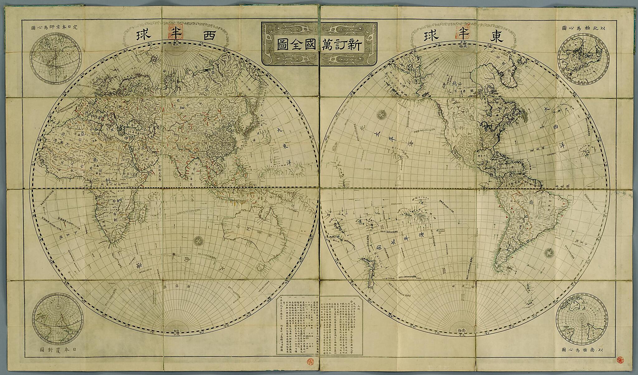
1829) of Tenmonkata (the office in charge of astronomy). He began the work on the 1807 by order of the shogunate government, with the assistance of astronomer Hazama Shigetomi and Dutch interpreter Baba Sajūrō, who was summoned to Edo (present-day Tokyo) from Nagasaki in 1808. Kageyasu submitted the first version of the map to the government in 1810. The East Asian region was later revised and this version of the map was etched by Aōdō Denzen in 1816. The year of publication is not given on the map, but the date has been confirmed from other sources, including Ranyaku teikō (Navigation to study Dutch) by Ōtsuki Gentaku (completed in 1816). The map utilizes information gained from the Mamiya Straight crossing exploration of 1809, an expedition led by the Japanese explorer Mamiya Rinzō (1775-1844) to survey Karafuto (Sakhalin Island). In this map, what in the West is called the Western hemisphere is placed on the right side and called the Eastern hemisphere. In the four corners are subhemispheric maps, one of which (in the upper left) shows Kyōto at the center. These features make the map a distinctively Japanese creation. The map was originally printed in 16 parts and pasted onto one sheet. This copy, from the National Diet Library, was divided into two sections.Created by Denzen Aōdō, Sajūrō Baba, Shigetomi Hazama, Kageyasu Takahashi in 1816.
- Title devised, in English, by Library staff.
- Original resource extent: 2 sheets ; 113 x 98 centimeters.
- Original resource at: National Diet Library.
- Content in Japanese.
- Description based on data extracted from World Digital Library, which may be extracted from partner institutions.
Map Subjects
World Maps
Denzen Aōdō
Sajūrō Baba
Shigetomi Hazama
Kageyasu Takahashi
1816
- For the best legibility, order your map in the original size or larger. Most maps have intricate detail and small text that is best appreciated when the print size hasn't been reduced.
- Sizes labeled "Fits a Standard Frame" will drop right into any frame that you purchase in that size. The sizes that we offer are commonly available online and at most retail stores.
- Our standard sizes are recommendations based on the aspect ratio of the original map, but still may require some added "white space" in one dimension to fit.
- Non-standard sizes will require custom framing, and we suggest taking your print to the frame shop of your choice after you receive it for the best results.
- Custom sizes are available, simply contact us for a quote.
Below is an approximation of the scale of a few standard sizes, and how they might appear in your space.
