
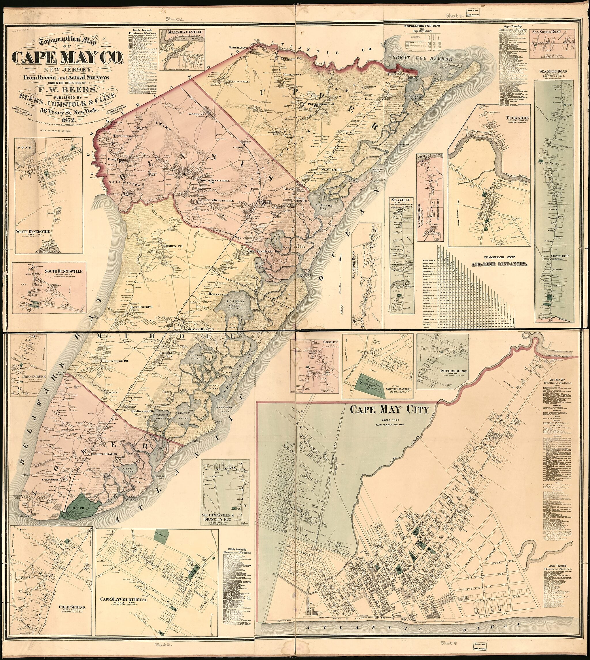
Topographical Map of Cape May County, New Jersey : from Recent and Actual Surveys 1872
- Regular price
-
$207.95 - Regular price
-
$202.95 - Sale price
-
$207.95
Buy one map, get any other map in our collection for 50% OFF! Add to cart to see discount.
Couldn't load pickup availability
About This Map
Discover the timeless beauty of our fine art quality printed reproduction of this antique map. Perfect for history enthusiasts, collectors, and interior decorators.
Restored with meticulous attention to detail by our team with over a decade of experience, this stunning reproduction captures the intricate artistry and historical significance of the original map.
Whether you're a collector or seeking a unique decor piece, this archival-quality map reproduction is a timeless addition to any space. Order now to bring history to life!
Old map of Cape May, Cape May County, Cape May Court House, New Jersey, United States.Created by Comstock & Cline Beers, F. W. (Frederick W.) Beers, Chas. (Charles) Hart, Louis E. Neumann in 1872.
- General-content county map also showing rural buildings and householders' names; city/village insets also show real-property tracts, building outlines, and owners' names.
- Hand col. to emphasize township boundaries, township territories, and insets.
- Originally printed on 4 sheets (later conjoined).
- Land Ownership Map
- Includes "Table of air-line distances", business directories, and population table.
- City and village insets: Cape May City -- Cape May Court House -- Cold Spring -- Green Creek -- South Dennisville -- North Dennisville -- Marshallville -- Sea Shore Road [4 insets] -- Tuckahoe -- Seaville -- Petersburgh -- South Seaville -- Goshen -- South Mayville & Gravelly Run.
- 2 copies
Map Subjects
Cape May
Cape May (N.J.)
Cape May County
Cape May County (N.J.)
Cape May Court House
Cape May Court House (N.J.)
Cities And Towns
Landowners
New Jersey
Real Property
United States
Villages
Comstock & Cline Beers
F. W. (Frederick W.) Beers
Chas. (Charles) Hart
Louis E. Neumann
1872
- For the best legibility, order your map in the original size or larger. Most maps have intricate detail and small text that is best appreciated when the print size hasn't been reduced.
- Sizes labeled "Fits a Standard Frame" will drop right into any frame that you purchase in that size. The sizes that we offer are commonly available online and at most retail stores.
- Our standard sizes are recommendations based on the aspect ratio of the original map, but still may require some added "white space" in one dimension to fit.
- Non-standard sizes will require custom framing, and we suggest taking your print to the frame shop of your choice after you receive it for the best results.
- Custom sizes are available, simply contact us for a quote.
Below is an approximation of the scale of a few standard sizes, and how they might appear in your space.

