
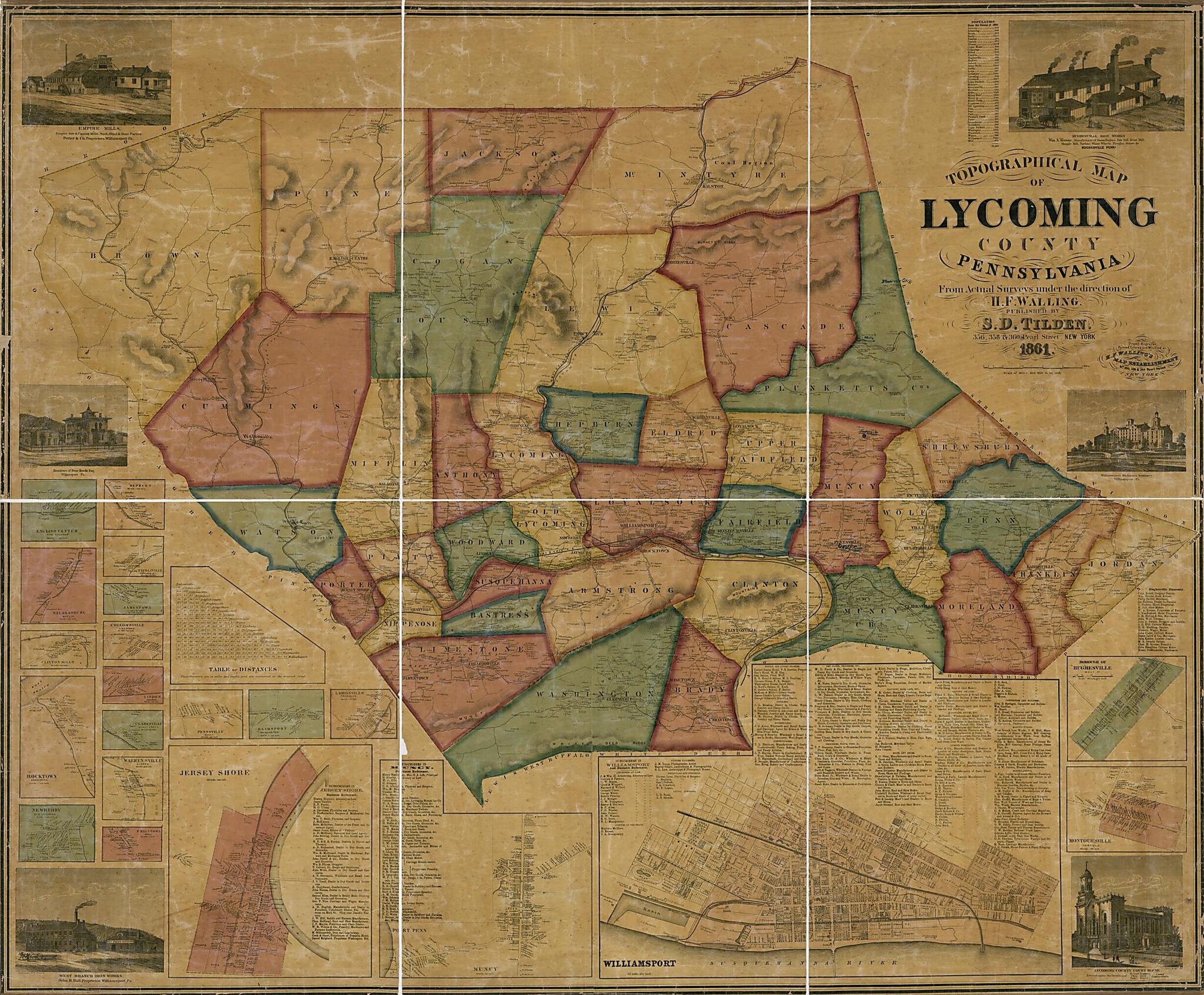
Topographical Map of Lycoming County, Pennsylvania : from Actual Surveys 1861
- Regular price
-
$214.95 - Regular price
-
$209.95 - Sale price
-
$214.95
Buy one map, get any other map in our collection for 50% OFF! Add to cart to see discount.
Couldn't load pickup availability
About This Map
Discover the timeless beauty of our fine art quality printed reproduction of this antique map. Perfect for history enthusiasts, collectors, and interior decorators.
Restored with meticulous attention to detail by our team with over a decade of experience, this stunning reproduction captures the intricate artistry and historical significance of the original map.
Whether you're a collector or seeking a unique decor piece, this archival-quality map reproduction is a timeless addition to any space. Order now to bring history to life!
Old map of Jersey Shore, Lycoming County, Pennsylvania, United States, Williamsport.Created by H.F. Walling's Map Establishment, S. D. (Samuel D.) Tilden, Henry Francis Walling in 1861.
- General-content county map also showing rural buildings and householders' names; town/village insets also show buildings and occupants' names; Williamsport and Jersey Shore insets also show real-property tracts, building coverage, and owners' names.
- Relief shown by hachures.
- Hand col. to emphasize township boundaries and territories.
- Originally printed on 4 sheets (later conjoined).
- This map has some imperfections: cracked, annotated in black/blue inks, cloth backing water-stained, hemmed at edges, cloth backing annotated in gray watercolor: lycoming co. pa. We'll do our best to restore the image before printing.
- Includes business directories, road distance table, table of "Population from the census of 1860", and ill. of prominent buildings/industries.
- Town and village insets (with township name qualifiers): Williamsport -- Port Penn, Muncy -- Jersey Shore -- Lairdsville (Franklin) -- Elimsport (Washington) -- Pennsville (Muncy) -- Uniontown (Brady) -- Newberry (Old Lycoming) -- Rocktown (Armstrong) -- Warrensville (Eldred) -- Clarksville (Muncy Creek) -- Linden (Woodward) -- Clinton Mills -- Collinsville (Limestone) -- Saladasburg (Mifflin) -- Jamestown (Limestone) -- Tivoliville (Shrewsbury) -- English Center (Pine Township) -- Hepburn -- Borough of Hughesville (Wolf Tp.) -- Montoursville (Fairfield).
- Land Ownership Map
- 2 copies
Map Subjects
Cities And Towns
Jersey Shore
Jersey Shore (Pa.)
Landowners
Lycoming County
Lycoming County (Pa.)
Pennsylvania
Real Property
United States
Villages
Williamsport
Williamsport (Pa.)
H.F. Walling's Map Establishment
S. D. (Samuel D.) Tilden
Henry Francis Walling
1861
- For the best legibility, order your map in the original size or larger. Most maps have intricate detail and small text that is best appreciated when the print size hasn't been reduced.
- Sizes labeled "Fits a Standard Frame" will drop right into any frame that you purchase in that size. The sizes that we offer are commonly available online and at most retail stores.
- Our standard sizes are recommendations based on the aspect ratio of the original map, but still may require some added "white space" in one dimension to fit.
- Non-standard sizes will require custom framing, and we suggest taking your print to the frame shop of your choice after you receive it for the best results.
- Custom sizes are available, simply contact us for a quote.
Below is an approximation of the scale of a few standard sizes, and how they might appear in your space.

