
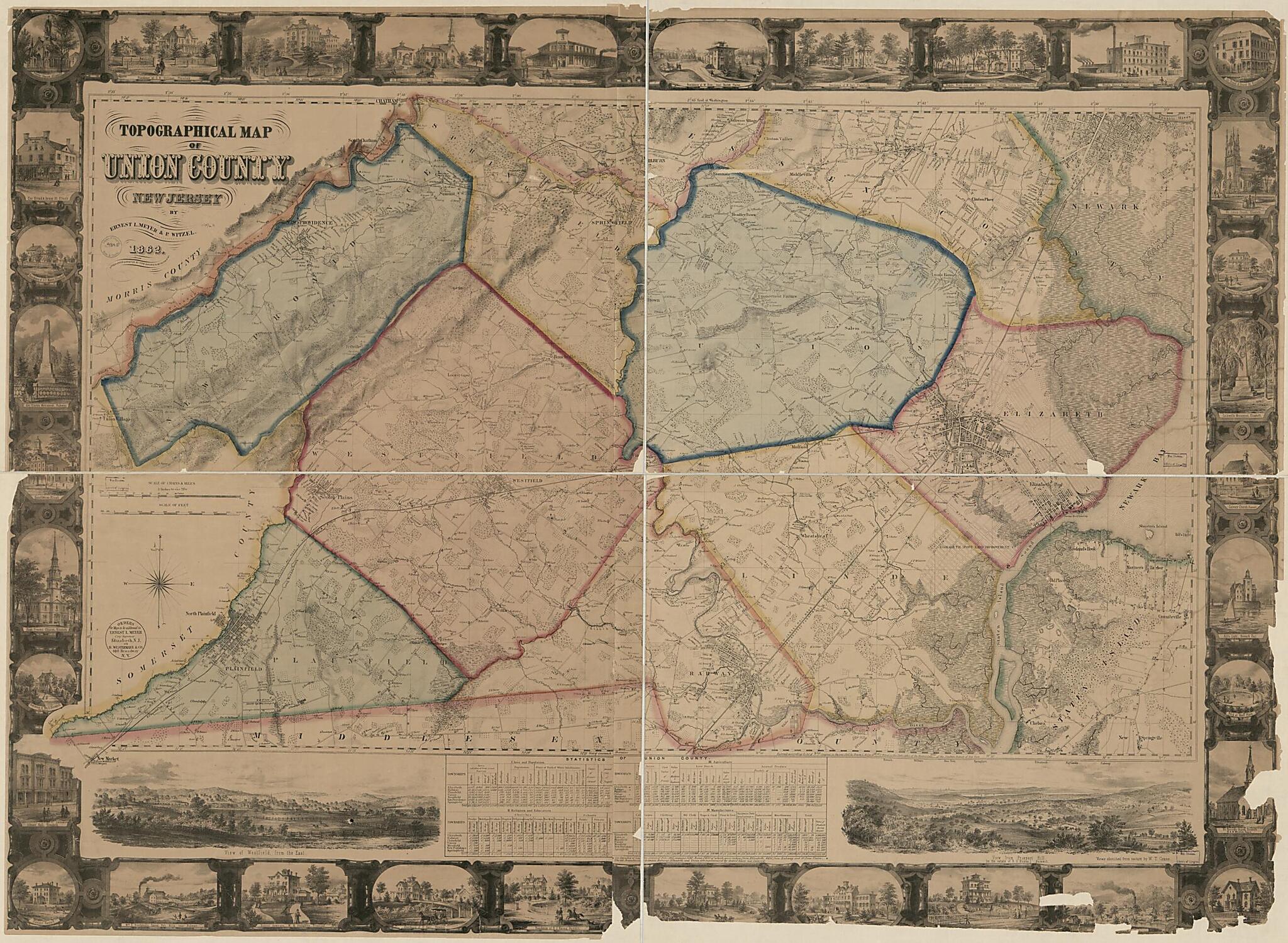
Topographical Map of Union County, New Jersey in 1862
- Regular price
-
$221.95 - Regular price
-
$216.95 - Sale price
-
$221.95
Buy one map, get any other map in our collection for 50% OFF! Add to cart to see discount.
Couldn't load pickup availability
About This Map
Discover the timeless beauty of our fine art quality printed reproduction of this antique map. Perfect for history enthusiasts, collectors, and interior decorators.
Restored with meticulous attention to detail by our team with over a decade of experience, this stunning reproduction captures the intricate artistry and historical significance of the original map.
Whether you're a collector or seeking a unique decor piece, this archival-quality map reproduction is a timeless addition to any space. Order now to bring history to life!
Old topographic map of New Jersey, Union County, United States.Created by B. Westermann & Co, W. T. Crane, Ernest L. Meyer, P. Witzel in 1862.
- General-content map showing built-up areas, urban buildings, rural buildings with occupants' names, extant/planned streets, woods, orchards, and marshes.
- Relief shown by hachures.
- Hand colored (watercolors) to emphasize township boundaries and territories.
- "Orders for maps to be addressed to Ernest L. Meyer, City Surveyor, Elizabeth, N.J., or B. Westermann & Co., 440 Broadway, N.Y."
- "Entered according to Act of Congress in the year 1861 by Ernest L. Meyer & P. Witzel in the ... Southern District of New York."
- Originally printed on 2 or 4 sheets (as wall map?) which may or may not correspond with the present fold lines.
- Land Ownership Map
- Includes notes, statistical tables, embellished border containing illustrations of prominent buildings (identified), 2 bar scales, and 2 landscape "Views sketched from nature by W.T. Crane".
Map Subjects
Landowners
New Jersey
Topographic Maps
Union County
Union County (N.J.)
United States
B. Westermann & Co
W. T. Crane
Ernest L. Meyer
P. Witzel
1862
- For the best legibility, order your map in the original size or larger. Most maps have intricate detail and small text that is best appreciated when the print size hasn't been reduced.
- Sizes labeled "Fits a Standard Frame" will drop right into any frame that you purchase in that size. The sizes that we offer are commonly available online and at most retail stores.
- Our standard sizes are recommendations based on the aspect ratio of the original map, but still may require some added "white space" in one dimension to fit.
- Non-standard sizes will require custom framing, and we suggest taking your print to the frame shop of your choice after you receive it for the best results.
- Custom sizes are available, simply contact us for a quote.
Below is an approximation of the scale of a few standard sizes, and how they might appear in your space.

